Hike to Lago di Antermoia, a beautiful alpine lake in the Dolomites, Italy
The Lago di Antermoia is a beautiful alpine lake you can only hike to in the Dolomites’ Catinaccio group, near Val di Fassa. The beauty of this lake is in the contrast between its calm, deep blue waters and the towering, jagged dolomitic peaks around it.

Situated at an altitude of 2,501m above sea level, all the hiking trails to the Lago di Antermoia are more or less challenging in terms of elevation gain, but the reward is worth the effort. The lake is of glacial origin, and it does not disappear in summer, because it is partly fed by subterranean sources, which help keep the waters of the lake its clear, deep blue color.
If you are in Val di Fassa, this is one of the best day hikes you can do, along with the hike to the Vajolet Towers.

Table of Contents
Overview of the Hike to Lago di Antermoia & Map
There are several ways you can hike to Lago di Antermoia. I chose to hike from the small village of Mazzin, as that’s the shortest, direct trail to get there. However, it’s also the trail with the steepest elevation gain, with 1,250m in 15km.
It’s also possible to hike from Campitello di Fassa if you are staying there, and the hike is about 20km long with the same elevation gain.
If you are staying in Pera di Fassa, you can hike to Lago di Antermoia from there too, via Val Udai. Alternatively, you could do a loop via Rifugio Vajolet. A longer hike at about 20KM and 1,500m elevation gain. This means you can also do it as an overnight and visit both Lago di Antermoia and the Torri del Vajolet on the same route.
Other than the effort required by elevation gain, the hike isn’t technical at all.
| Max Altitude | 2,520 m |
|---|---|
| Distance | 15.0 KM |
| Elevation gain | 1,250 m ↑ / 1,250 m ↓ |
| Hike time | 04:00/ 05:00 Hours |
| Hike Difficulty | Hard |
Here is the full map of the Hike. You can download the GPX file for free from the activity below, should you wish to do so:
How to get to the Lago di Antermoia trailhead and Parking
There are a number of ways you can get to this beautiful lake. The quickest way to hike to Lago d’Antermoia is from the small village of Mazzin and through Val Udai (Udal Valley). Regardless, you will essentially have to get to Val di Fassa and pick one of the trailheads from there.
- Driving Directions: You can reach Val di Fassa via the A22 Brenner motorway, taking the Bolzano Nord, S.S. 241 Grande Strada delle Dolomiti exit if you are coming from the North (Austria). Then it’s about 45km from there. If you are coming from the south, take the Ora/Egna, S.S. 48 delle Dolomiti exit.
- Parking: If you are planning to start the hike from Mazzin, there are a couple of parking areas around the small villages. I parked here, but it’s a rather small parking area, and there is a bigger one a little further down the road.
- Public Transport: Bus line 101 stops in Mazzin, to check timetables Alto Adige Mobility website.
The Lago di Antermoia Hiking Trail
From the parking area in Mazzin, you would first need to head into the village until you reach the bridge across the river. From there, you can follow trail 580. Then the trail initially follows the river upstream, before crossing it again, to begin the relatively steep ascent that will later reconnect with the trail from Campitello di Fassa.

Mazzin.

Follow trail number 80 to Val Udai at the beginning.
From the village, the trail initially follows a gravel road, and then it passes through the woods to re-emerge from the vegetation as it approaches the narrow Val Udai.
As you get you of the woods, you’ll also have some fantastic views of the landscape above Val di Fassa. Do note that in some sections here, a recent flood seems to have washed parts of the trail away. This means you’ll find some loose rocks on the trail, but it’s nothing too challenging.


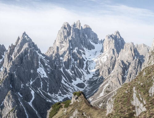
View of the mountains above Val di Fassa from Val Udai.
After this section, you’ll reach a sort of plateau/flat section, which is where this trail connects with the trail from Campitello di Fassa. Here, the views open up even further, revealing more of the landscape around the valley.
The last bit of the trail is another moderately steep section on scree, which at first zig-zags on the side of the mountain, to flatten out once you reach the other side, and Rifugio Antermoia comes into view.

Scree section of the trail.


Rifugio Antermoia.

From the Antermoia hut, it’s now just an easy walk to the lake, which is hidden behind a small ridge. As you walk past the hut, the lake will soon come into view. You can walk around the entire perimeter of the lake, and the best views of the towering dolomitic rocks are from the shores of the lake to your left.

Lago di Antermoia.


Antermoia Lake Photos and Photography Tips
This one is a bit of a tough lake to photograph, the main reason being that the lake is relatively small, and it is surrounded by gigantic, jagged peaks, and it’s rather difficult to fit everything in one frame, even at 14mm on full frame.
While this is an absolutely beautiful location, I think it isn’t the most photogenic lake around the Dolomites. So it’s probably not one to keep at the top of your list if you are visiting the Dolomites for the first time, unless you include it in a loop with the Torri del Vajolet, for example.
I think better chances, photographically speaking, would be trying at sunrise or sunset in autumn, when the first light of the day hits the peaks around the lake, tinting them in those warm colors. That won’t happen in summer, because the sun will rise behind the mountains above the lake.
However, there are plenty of opportunities to play around with the color of the water and the reflections of the mountains.


On the other hand, Val Udai provided some fantastic views. Especially in the early morning, when the sun hits the valley with some beautiful sidelight, the views and the whole landscape proved to be extremely beautiful.
In Autumn, when the landscape starts to take on the golden autumn colors, the Val Udai section of the hike to Lago di Antermoia is worth the effort in itself. Combine that with the golden morning light and a long lens, and you can get some decent autumn photos from there.


Where to stay
If it’s open, you could stay at Rifugio Antermoia, where you would need to book in advance. Or, if you are planning to visit more in the area, you could do a loop that includes the Vajolet towers. If you do that, you could also stay at one of the huts on that section of the trail.
Alternatively, anywhere in Val di Fassa is worth the stay for a couple of days of hiking and landscape photography in the area.
Additional Resources
- View my main page on Hiking in Italy.
- Here’s the Rifugio Antermoia‘s official website

Leave A Comment