Hike Le Cinque Terre, Beautiful Villages, Mountain Trails, and Stunning Landscapes, Liguria, Italy
The full hike along Le Cinque Terre is a long day hike on a trail between Monterosso and Riomaggiore. Le Cinque Terre is a UNESCO site and lies within its own National Park, Parco Nazionale Le Cinque Terre.
It is one of the most renowned hikes in Italy and a major tourist attraction in itself, not only for hikers. It is easy to see why. Beautiful, colorful villages seemingly built atop cliffs on mountainsides that dive straight into the Ligurian sea. It’s one of those places that may make you wonder – do people really live here? Yes, they do.
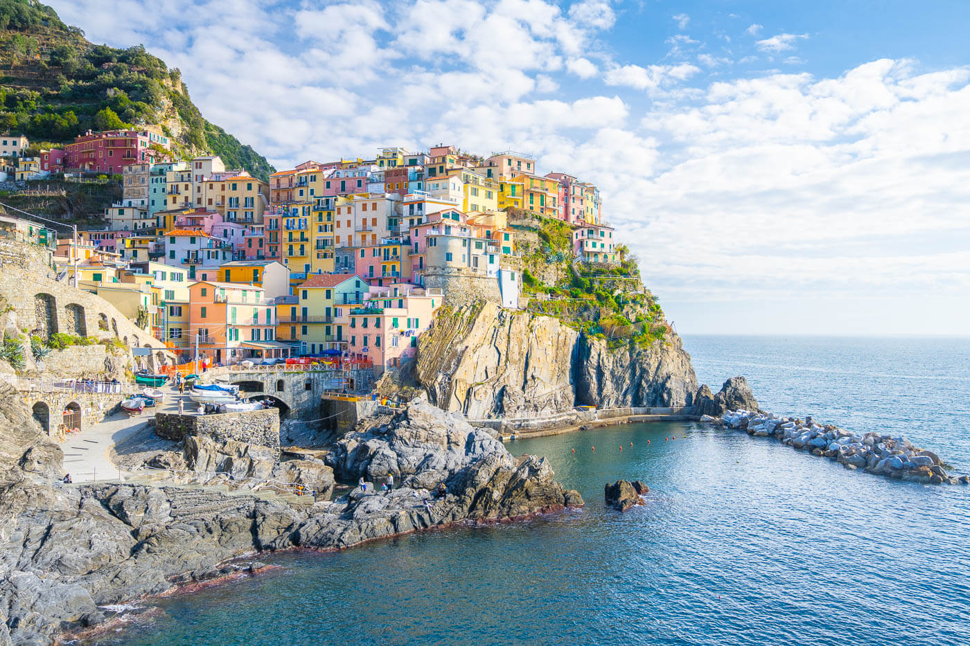
View of Manarola.
Apart from the beautiful landscape and the little towns along the coast, there are a lot of hiking trails connecting the villages along the coast and other inland areas. They have been there for centuries and have cultural and historical significance.
As mentioned above, this is a very long hike, one-way. It is rather demanding, with more than 1,000m total elevation gain, with lots of up and downhill sections. However, the small towns are also well-connected by a railway network, so for anyone wanting to just hike part of the trail, that’s a convenient option. Regardless of which option you chose, the views and the landscape are absolutely worth it.
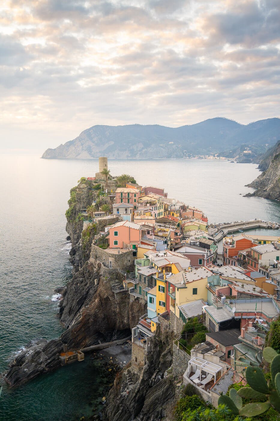
Sunset in Vernazza.
Table of Contents
Best time to Hike Le Cinque Terre
This is one of the best things about hiking le Cinque Terre: you can hike them all year round! While Summer is the most popular time of the year among visitors, the Ligurian weather is very moderate in winter.
With temperatures often ranging between 10-20 Celsius during the day when the sun is out, Le Cinque Terre makes for a nice winter break, away from colder regions south and north of the Alps.

Le Cinque Terre in Winter can make for a great, short break away from the cold in Northern Europe.
Summer will be very crowded, especially in July and August. And that makes sense; it’s warm, sometimes too much though, and you can dip in the blue waters of the Ligurian sea. Spring and Autumn are a little less crowded.
So if you can, visit in Winter. I did too, and while there were still tourists, the trails were very enjoyable, the towns not too crowded, and I was still able to hike in a t-shirt. I actually wished I had shorts too during the day.
Overview of the Cinque Terre Hike & Map
There is a whole network of hiking trails around Le Cinque Terre. There are multiple trails between Monterosso and Riomaggiore and beyond them for those who want to explore further. For instance, Levanto or Porto Venere could be included to make this a multi-day hike.
The whole hike is quite hard. The terrain is often steep, and the elevation gain is spread across several uphill and downhill sections. Some sections are moderately exposed, but the trail is usually quite large in such sections. Others are narrow passages wide enough for one person only.

One of the many steep sections in Le Cinqie Terre. View toward Manarola.
Technically, the trail is a little over 14km long, but with all the villages in between to explore, you’ll realistically have to add a few KM to that. For instance, my additional exploration and walks around the beautiful towns of Le Cinque Terre, the Hike ended up being almost 20 km.
However, Le Cinque Terre is also nicely connected by train. So if you don’t feel like hiking the whole train, you can jump off between towns. However, if you want to hop between towns or have freedom of movement, it makes sense considering the hiking and train pass.
Important:
- You need to purchase a pass. You can buy it on the official website, and there are a few different options, the main ones being the hiking pass with or without “sentiero dell’amore”, and the hiking+train pass with or without “sentiero dell’amore”. I purchased the standard hiking pass. It makes sense if you want to hike the whole trail and get back to the starting point. Each option is available for one or more days. Purchase tickets here: https://card.parconazionale5terre.it/en. Also, keep in mind you’ll still need a pass even if you plan to hike between two towns.
- Bring Proper Footwear: You are required to wear proper hiking footwear with grippy soles, i.e., Vibram or similar. This isn’t “a walk in the park”; it’s a proper mountain hike for the most part.
- Check out warning and trail closures: monitor the Cinque Terre official website for possible trail closures or warnings before heading out.
There are also several guided walks and tours in Le Cinque Terre, if you prefer to have someone take care of all the logistics.
Now with the basics covered, here’s an overview of the whole hiking trail between Monterosso and Riomaggiore:
| Max Altitude | 375 m |
|---|---|
| Distance | 19.3 KM |
| Elevation gain | 1,320 m ↑ / 1,290 m ↓ |
| Hike time | 07:00/ 08:30 Hours |
| Hike Difficulty | Hard |
Here is the map of the Cinque Terre Hike. You can download the GPX file for free from the activity linked below:
How to get to the trailhead and Parking
The best place to start the hike entirely depends on where you are coming from. Generally speaking, you should start the hike either in Monterosso or in Riomaggiore. These are the two “outer” villages out of the five.
Generally speaking, if you come from the north or the west, Milan, Turin, or Nice, Monterosso will be the closest village. If you are coming from the south or the east, like Rome, Florence, or Bologna, it’s probably best to park in La Spezia and take the train from there, especially in summer. You could technically drive to one of the parking areas in Riomaggiore,
- Driving Directions: By car, you can reach Le Cinque Terre via Highway A12 Genova-Livorno (E80), and take the Carrodano-Levanto exit to get to Monterosso. If you want to hike le Cinque Terre from Riomaggiore, take the La Spezia Exit, then follow directions to Riomaggiore. Once you leave the highway, you’ll have to drive on sometimes narrow, winding roads, so caution is required.
- Parking: There are a few options at both locations. I parked in Monterosso at the Fegina Parking, right by the beach. A great location to start the hike from. For a complete overview of all the parking areas, see the following websites: Parking in Monterosso: https://www.cinqueterre.eu.com/en/parking-monterosso. Parking in Riomaggiore https://www.visitcinqueterre.eu/en/useful-info/parcheggi/.
- Public Transport: The Italian railways don’t have the best rep for being efficient. However, here the trains are quite frequent and efficient. This makes train transportation a good way to move around and between le Cinque Terre. All the stations have ticket machines, or you can purchase tickets from Trenitalia. Here, too, you have the option to purchase Cinque Terre tours with transportation included.
The Cinque Terre Hiking Trail – From Monterosso to Riomaggiore
Here is the full overview of each leg in this trail. I have added the approximate distance between towns for anyone wanting to plan the hike around distances or just hike between any one of those villages.
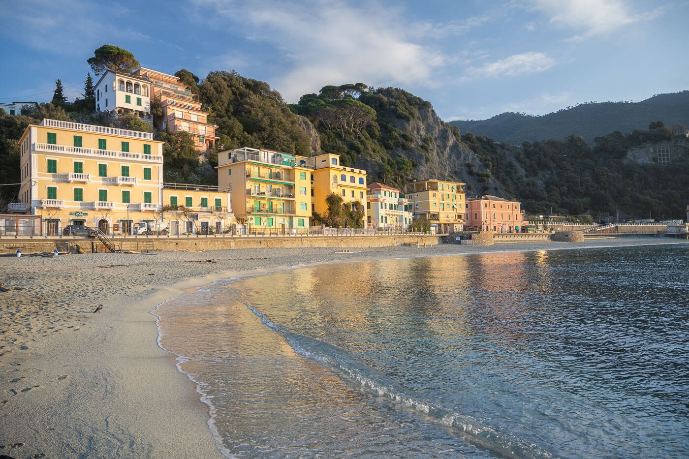
Monterosso beach.
From Monterosso To Vernazza (5km)
This is the first leg of the trail. Either from Monterosso’s train station or the big parking area, you’ll initially walk on the “lungo mare “, the broad walkway along the beach. The trail follows the coast and passes below the “Convento dei Cappuccini”, or Capuchin Monastery. This is a small outcrop passed which you’ll see the “old” Monterosso Town.

Monterosso.
Although it isn’t as scenic as other villages further down the trail, Monterosso still has a nice “old town” look, and it’s worth taking a short detour through it.
As you leave Monterosso, the trail will lead you through narrow passages and steep stone stairs across the terraced gardens of local farmers and up into the mountains.
Vernazza will come into view only once you have essentially reached it. There’s a nice viewpoint right above the small town that offers a great view of its small bay and the colorful houses around it.
It’s one of the main and most visited viewpoints in Le Cinque Terre and a must-visit photo spot.

Vernazza viewpoint.
Overall, Vernazza is one of the nicest Cinque Terre villages and is worth a stroll through its small alleys. You can stop for a bit or a slice of “Focaccia” in one of its “Panetterie” (bakeries). Or take a coffee in one of its bars. I did both.
It’s nice enough to walk through its little alleys, and easy to lose track of time. That’s why the hike can get much longer than planned, all the walking through le Cinque Terre’s little villages.

One of the many little alleys in Vernazza.
It can take a bit too, to find the right path out of Vernazza, trail marks are somewhat sparse and poorly signed in the villages.
Then, as you leave town, you’ll get the other iconic view in Vernazza, Castello Doria. Don’t follow directions to the castle unless you want to visit it. The viewpoint is right on the trail. It’s rather small, and it can get crowded at sunset.

The other main viewpoint in Vernazza, with a view of the Doria Tower above the village.
From Vernazza to Corniglia (4.5km)
Corniglia is the “middle” village, the one in between the other four. In my opinion is the least spectacular of the villages, probably that’s because there are no good viewpoints of Corningla from the coast.
Though you do have some amazing views of Corninglia from the trails around it.

Corniglia.

View of Corniglia from the hiking trail to Manarola.
But back to the trail. As you leave Vernazza, the trail picks up elevation and continues for a while above the cliffs and through the gardens of local farmers.
Long stretches of the trail are in the dense vegetation of the mountains, but here and there the views open up.
Then the trail gently descends into Corniglia, passing right by the village’s church. Then the trail abruptly picks up elevation, heading back uphill into the woods.

From Corniglia to Manarola (6km)
The stretch of trail between Corninglia and Manarola is probably the hardest in terms of length and elevation gain. It’s about 270 m of elevation gain and more than 300 in elevation loss across the 6km or so of the trail between the two villages.
It is also further away from the coast, and for long stretches, it is a walk in the woods.

Approaching Manarola.
Manarola is possibly the most beautiful village of Le Cinque Terre. The most popular. It’s easy to see why. Built on the rock with its many colorful houses that also appear to be built one on top of the other. With its little harbor, Manarola probably is the most charming of the villages in le Cinque Terre.
The hike to get there is long, and it involves a significant elevation gain. Long stretches of the trail are in the woods, too, away from the coast. Still, the views open up here and there, revealing great views of both Corniglia and Manarola from a distance.

View from Trail 502, above Manarola.
Again, the trail crosses many private gardens and a few conglomerate or huts. There are some “refreshment” points along the way where landlord owners offer local products for sale and where you can stop to taste them, including locally produced wine.
Approaching Manarola, the trail steeply descends toward the coast again. There are 2-3 different paths you can take, but I’d recommend taking Trail 501 instead of 506 to the panoramic viewpoint. It’s just better views above the town.

View from Trail 501.
From there, you can continue toward the coast, and you will end up at the main panoramic viewpoint, which is located just below the town’s cemetery.
The panoramic viewpoint in Manarola was by far the most crowded one, but it is also the largest. It’s spread across two levels too, and from there you can walk back into the small village

Manarola “upper” viewpoint.

Manarola “lower” viewpoint.
You can also walk down to the little harbour below town, where you’ll find some benches you can sit on and enjoy the views. Manarola is also another good stop for some food, snacks, or drinks.
Here I ate a slice of “Torta Pasqaualina”, a salty cake with spinach, and a slice of “Focaccia al Formaggio”, or cheese focaccia, two typical snacks from the region. Hey, it’s Italy, you can’t leave without a positive calorie intake even after such long hikes :).
Then I had another coffee before going back to the trail to reach the last village, Riomaggiore.

Fishing boat in Manarola.

Manarola, view from the dock.
From Manarola to Riomaggiore (3km)
The last leg in this hike is relatively short, but steep on either side. The elevation gain is about 200m in one KM, so quite a step gradient, but there are steps built on most of the trail to help with that.

From Manarola, the trail rapidly climbs up the side of the mountain to a viewpoint above the cliffs. From that viewpoint on top of the cliff, you can enjoy the view of the open seas and the coast on either side of the mountain.
The trail then again steeply descends toward Riomaggiore. You will enter the village right above the train station. From here, the quickest way to reach Riomaggiore’s scenic viewpoint you can take the elevator down to the station, walk through the pedestrian tunnel, and then turn right when you see the “Marina” sign.

Riomaggiore Upper viewpoint.
I didn’t take that shortcut and instead just walked through the village, thinking I’d soon come across it. Big mistake! The little alleys of Riomaggiore can soon turn into a maze, and with no panoramic views of the landmarks around you, it’s easy to get lost in it. So maybe save the little alleys tour for later :).

A square in Riomaggiore.
Do note that if you are hiking the 5 Terre from Riomaggiore, you also have the option to take the “Via dell’amore”, a 900m seaside trail that can only be walked one way. For the price of 17,5 euros, as of 2025. It was a hard pass for me, but just mentioning it for completeness.
Return to the Starting Point
You made it! Now, as you need to get back to the starting point, your visit may not be over yet. Mine wasn’t. On the way back with the train, I revisited two of the five villages. Vernazza and Manarola, to take more photos, grab a bite or two (and a beer or two), and generally just enjoy the views at an unhurried pace, now that the hike is completed.
I’d recommend doing the same if time allows it. Just make sure your train ticket allows multiple stops, as, in some cases, the train tickets are valid only for specific trains or stops.
La Cinque Terre Photos and Photography Tips
Photographically speaking, Manarola, Vernazza, and Riomaggiore are the most interesting villages. Apart from what I have already mentioned, I’ll add a few more tips.
In terms of lenses, a range between 18mm to 70mm is the most handy. I took the photos in this post mostly using a 24-70mm lens (full frame), with a few wider shots using a 14-24mm lens. I also had my 70-200 lens, which I lugged around unused.
To make the most out of your visit, here’s a table of what I think are the best towns and times of the day:
| Vernazza | Sunrise, Sunset, Golden Hour (Afternoon), Blue Hour |
|---|---|
| Manarola | Sunrise, Golden Hour (Morning and Afternoon), Blue Hour |
| Riomaggiore | Sunset, Golden Hour (Afternoon), Blue Hour. |
On my trip, I planned to catch the golden hour in Riomaggiore, then Sunset in Vernazza, and lastly the Blue hour in Manarola. I left Riomaggiore a little early, because I didn’t want to miss sunset in Vernazza, which was a bust and already full of people about an hour before sunset.
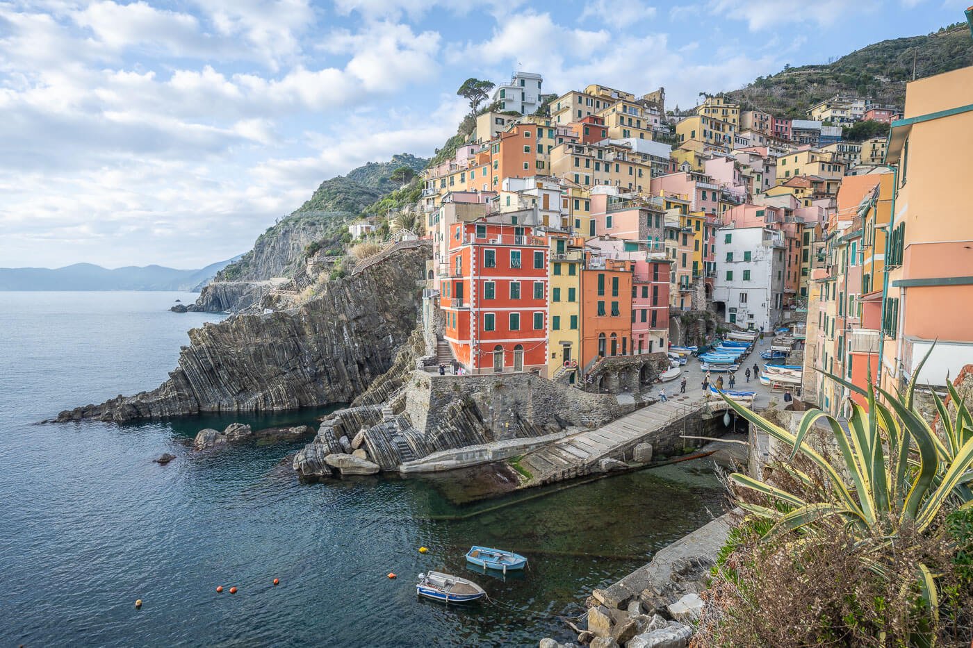
Riomaggiore.
There isn’t much room at the main Viewpoint in Vernazza. I would say spots for 5/6 photographers with tripods at best. So you’d have to be there quite early in case someone is leading a photo tour there, or join one yourself.
Sunset in Vernazza
But back to my little disadventure – I then went to Manarola for the blue hour – but it was pretty much night already as the train ran late.
So in that sense, the mission failed, but such is landscape photography. Sometimes it works, sometimes it doesn’t, and sometimes you get surprised.
Anyway, this was just to say if you have one day/evening in the area, you can try to juggle these three locations for sunset too.

Manarola by night.
Video of le Cinque Terre Hike
Last but not least, here’s also a video of my hike across all of the Cinque Terre
Where to stay
If you are planning to hike the whole trail, it makes sense to either stay there the night before, or the same night of the hike, or both.
In such cases, you would want to stay either in Monterosso or Riomaggiore, depending on the direction of travel. Or you could stay in between if you prefer to split the hike over two days.
If you are doing this hike in winter and are with a Camper or a Van, you could spend the night at the parking area in Monterosso. That’s also where I spent the night after the hike. It’s paid, has no facilities, but it’s a quiet area. Note that the area is forbidden to campers in summer/high season.
Additional Resources
- Here’s the main page on Hiking in Italy for more hikes and scenic spots in Italy.
- Cinque Terre official website.
- For a detailed cartography of the area and check out the Website of La Spezia’s CAI (Club Alpino Italiano). Here is the map.

Leave A Comment