The Reinebringen Hike on the Lofoten Islands – Norway
The Reinebringen Hike on the Lofoten Islands is likely to need no introductions. If you landed on this page, chances are you’ve already heard about this hike and its fantastic views over the fjord.
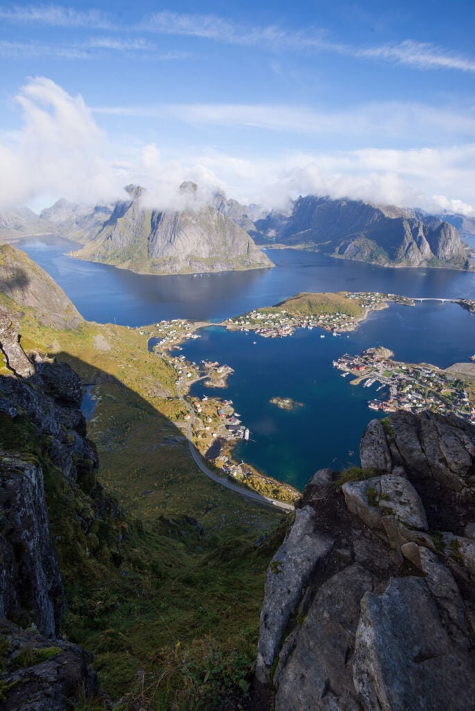
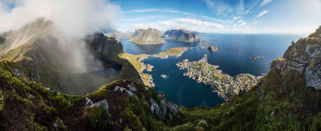
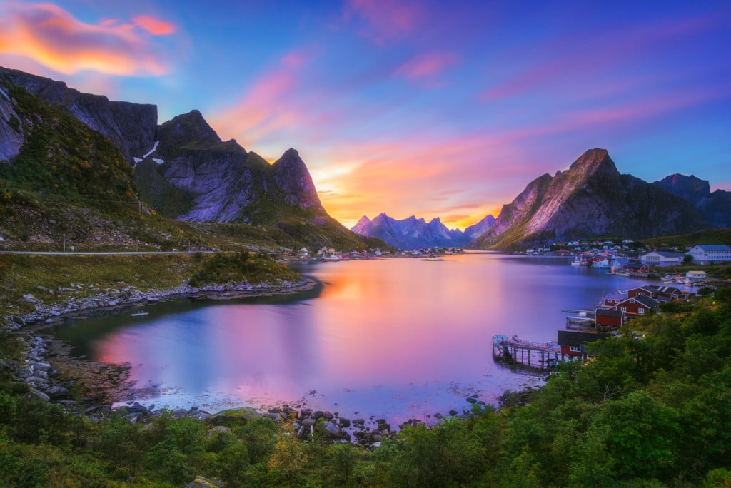
With views like this, you will remember the Reinebringen hike on the Lofoten Islands for a very long time. From time to time, I find myself daydreaming about hiking in the Lofoten and sceneries like this:
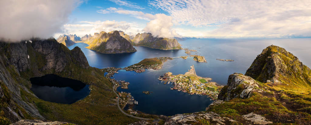
All I can do is confirm the hype about Reinebringen is real. The views are truly superb and well worth the steep but easy hike.
Well, about the hike, it isn’t an actual hike anymore, but rather a very long stairway that reaches almost the top of the mountain. So you could call it a Stairway to Heaven! Once on top, you’ll be as happy as this guy was:
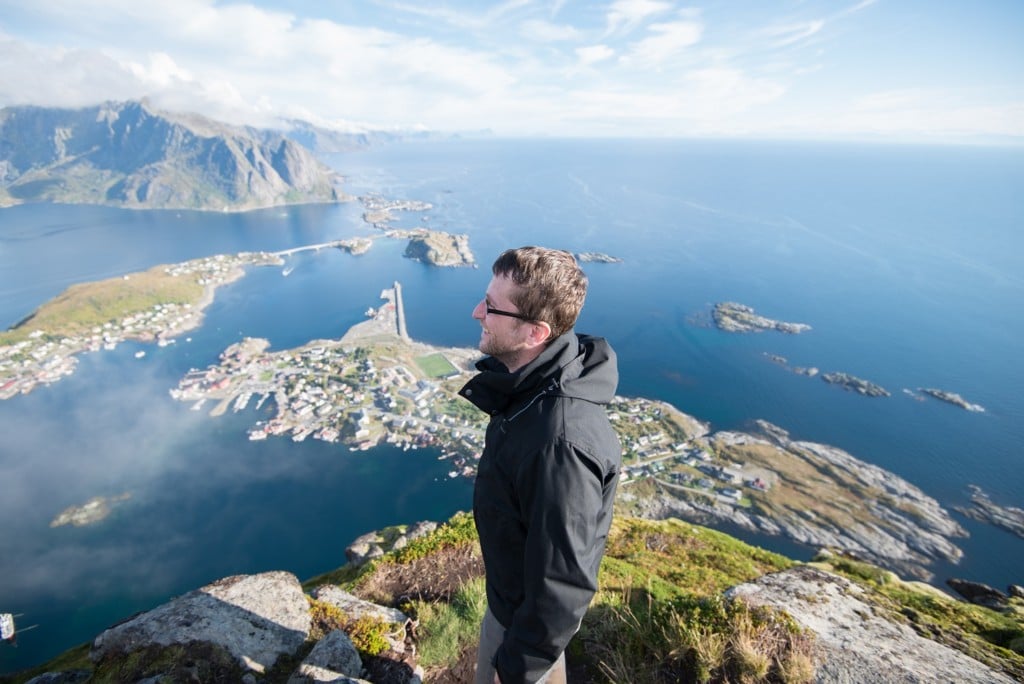
Me, staring at the view with a smile I could not get off of my face
There are a few factors you should think about when planning your trip if you want to get the best value out of it. Getting to the Lofoten Islands requires a long travel time unless you already live in the area, so I will highlight a few points for you to make an educated decision.
When can you hike to Reinebringen?
- This location will be inaccessible in winter unless it’s snow and ice-free. If there is snow, there is a considerable risk of avalanches. The same may apply to early spring and late autumn. So I would exclude winter if you want to hike up Reinebringen.
- The light varies significantly during the year: you will have daylight 24 hours a day from mid-May to mid-August. Therefore, if the weather cooperates, sunsets and sunrises will be merged into a long “sunriseset“. However, keep in mind this time of the year is also the most crowded. However, if you plan to see the midnight sun, you can only do that at the beginning of summer.
- Do you want to catch a glimpse of the northern lights too? Late August to mid-October will provide you with the best chances of spotting the elusive Northern lights from there. You can also try February to early April, but if there is snow, you will not be able to make it to the top.
Personally, my favourite season to go is late summer/early autumn. The balance between daylight and night is primarily even. Sunset and sunrises, as well as twilight, are still quite long. This gives you more time to plan and compose your shots.
This also means you have more than enough time for your hikes during the day and time to chase the northern lights at night! Does that sound like a sleep-deprivation holiday :)? Yep, that also means little time to sleep. But hey, those trails won’t hike themselves, and those shots won’t shoot themselves, right?
Also: this is the Arctic, and the weather can be somewhat unpredictable. Have a waterproof jacket or similar with you.
Ready to go? Let’s get started!
How to get to Reinebringen and Parking
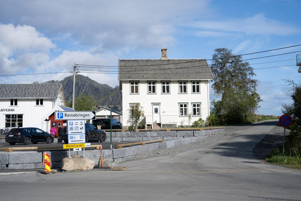
- Getting there: Following Road 1 from the North, you will see various road signs pointing to different paid parking areas for Reinebringen. The best option is to just follow directions to the only gas station in Reine, the Circle K.
- Parking: the Reinehalsen viewpoint, which was limited to 4-hour parking in the past, has not been closed off. Now it’s just a stop for a pretty picture. The most common parking area is Ytre Havn (Inner Harbour), 40NOK/Hour. You can also pay with EasyPark. Another paid option is the Reine Kultursenter, before the gas station. It costs 150NOK per day, pay inside. Lastly, there is also a free parking option further south (after the tunnel) on the Djupfjord, right after the Djupfjodbrua.
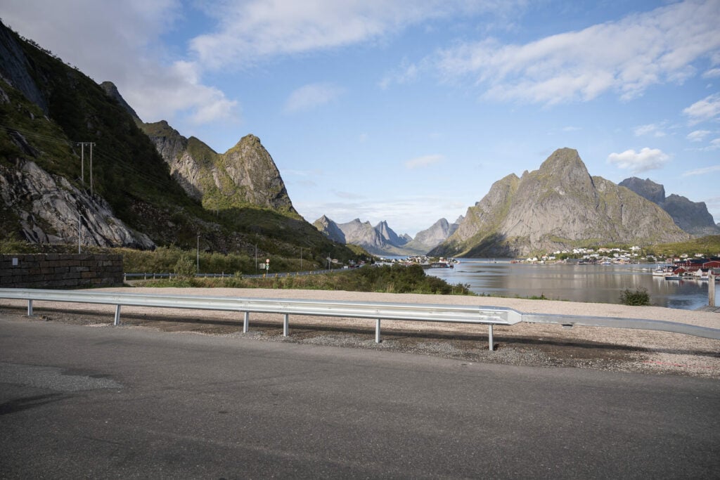
Reinehalsen.
Ytre Havn Parking.
- Start of the Hike: From Reine/Ytre Haven follow the road South towards Å. You will see more signs pointing to the trailhead. Take the paved path on the left and keep heading south till you find a sign marking the start of the hike. Pay attention! There still are some visible signs pointing to the old abandoned path. Make sure your Hike starts where the Staircase starts, or it means you’ll be on one of the old sketchy trails.
- Difficulty: easy, but this is still a leg-burner; the stairway is on a steep gradient. However, there will be a few stone benches here and there you can sit on to catch your breath if you need to.
- Tip: for similar views and a far less crowded but more challenging hike, you may want to check out the Helvete/Veinestinden hike.
The Reinebringen Hiking trail
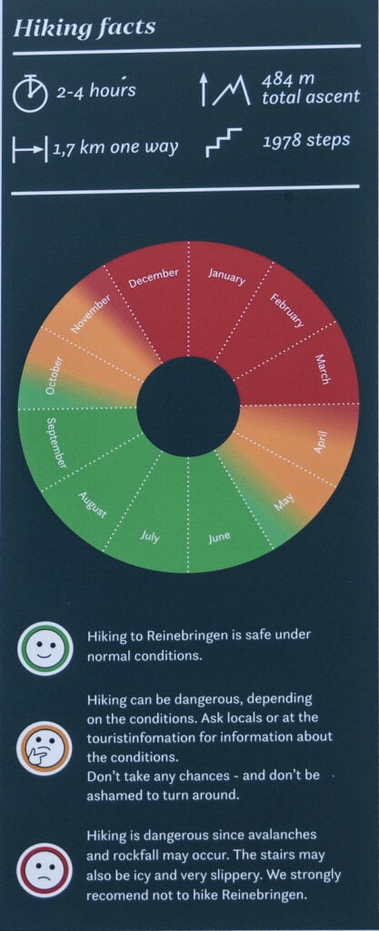
| Distance | Ascent | Duration |
|---|---|---|
| 3.7 KM | 484 mt. | 2/3 Hrs. |
It’s pretty easy nowadays; it’s a stone staircase almost to the top, except for the last 50 meters. The local council brought in Sherpas to build the stairs. The construction lasted about three years, from 2016 to 2019.
As bad as it may sound for a hiker, it was a much-needed improvement due to the erosion and conditions of the trail. While it does not feel like an actual hike going up the stairs, it is now much safer.
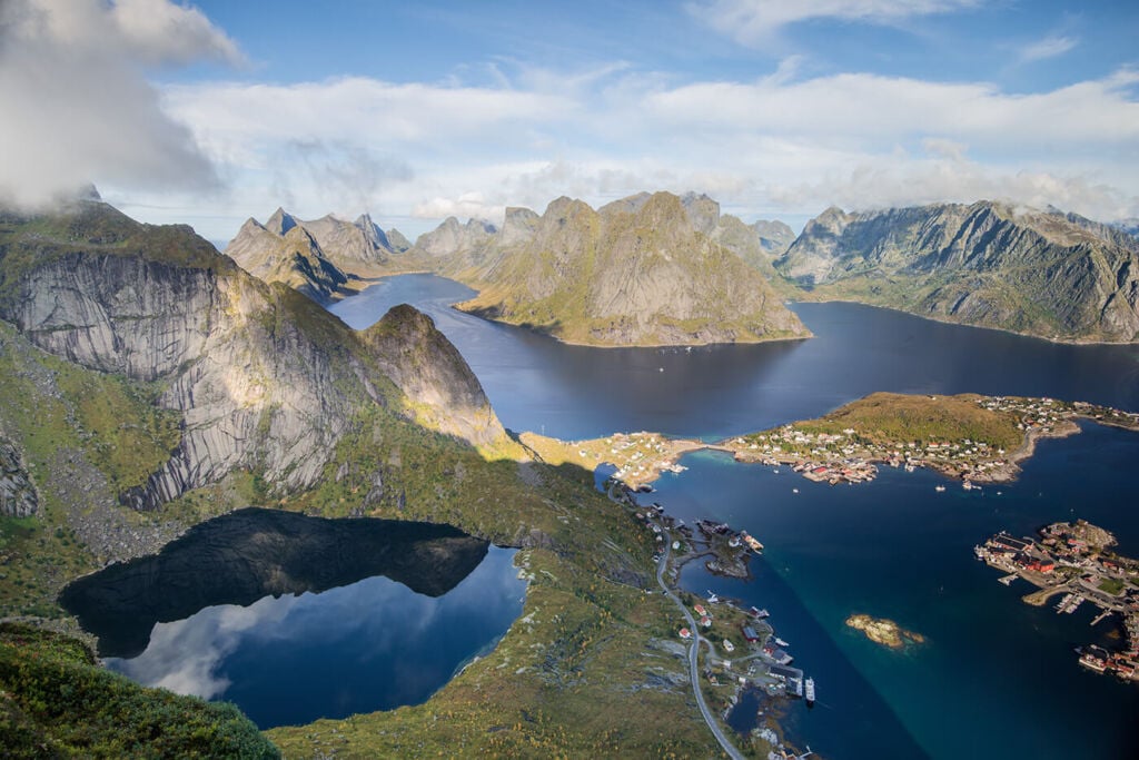
View over the steep hike that leads up to Reinebringen
There are a total of 1978 steps on the stairs that lead up to Reinebringen. Most of them are rather wide and not too high, so you should not have any problems getting a good foothold in between steps.
The last bit has not been “staircased” and it’s likely to be in bad conditions although not very steep or difficult to get across.
Keep in mind the top of Reinebringen has cliffs on each side. Carefulness is required, especially when approaching the cliffs.
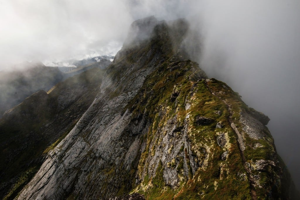
The ridge trail on top of Reinebringen
Anyways, you will find a few stone benches on your way up, so if you need a break from the stairway, you can sit and soak in the views while you recover your energies.
The trail and the top are likely to be crowded. This is likely the most popular hike in the Lofoten Islands along with Ryten/Kvalvika Beach.
Once up there, find a spot to sit, have a snack and a drink, and enjoy the views!
Photos and Photography Tips for the Reinebringen Hike in the Lofoten Islands
Let’s start with the obvious. The vistas from the top of the ridge are the absolute best. Of course, you’d want a wide-angle lens to include some foreground, but you will also have fun with a telelens looking for composition over the fjord and the surrounding mountains.


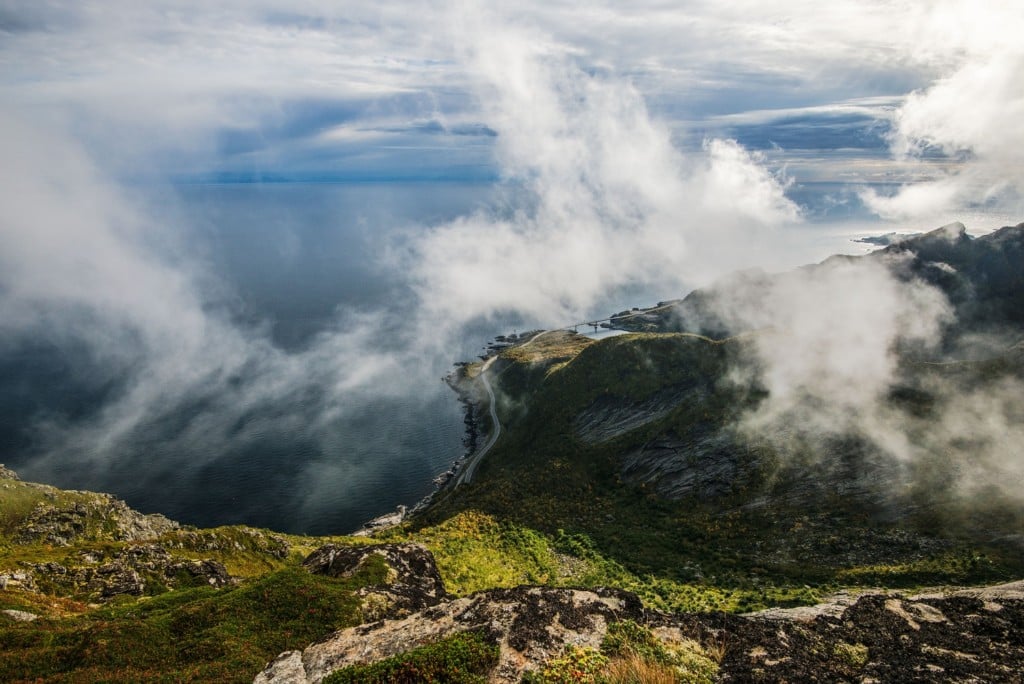
However, clouds often cover the summit, so you may have to wait to glimpse the panorama. Nevertheless, in some cases, and if the time of the day is right, you may be able to catch your own Brocken spectre!
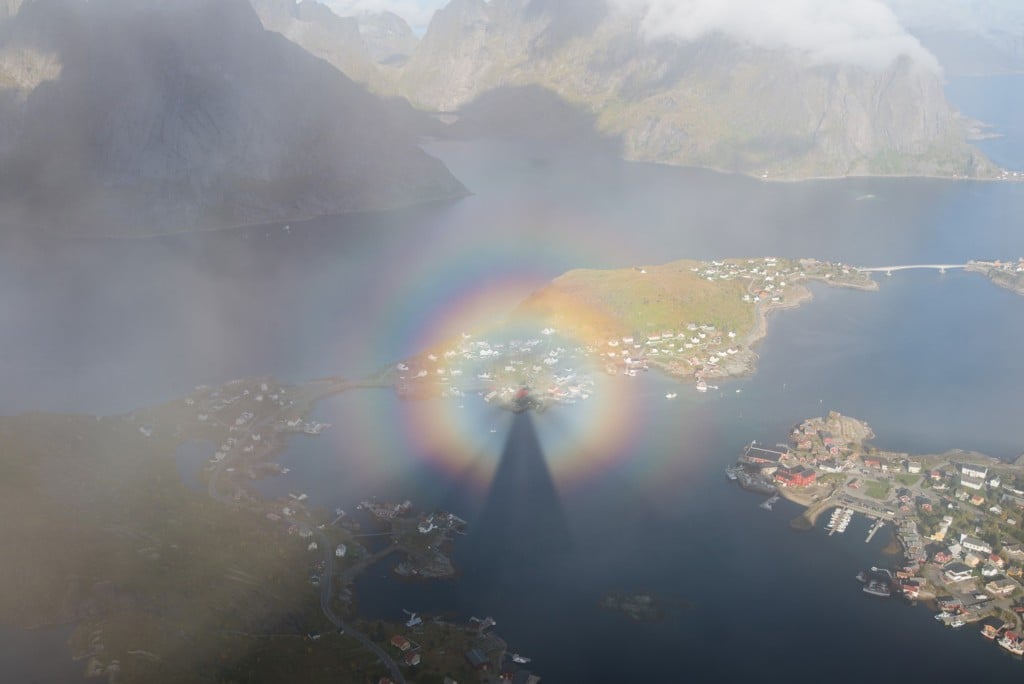
My own Brocken Spectre
As mentioned in the introduction, the light and direction of the sun here will vary greatly depending on the season. Therefore, I would also recommend using sun position calculators like SunCalc to plan for your preferred lighting conditions. Still, generally speaking, this is an excellent location for any time of the day, Sunset and Sunrise.
Bring a powerful head torch if you plan to hike up there to catch the northern lights. The top is not a location where you want to trip over a stone or miss a step.
To sum it up, apart from the views, it’s a fantastic location to shoot. I would not recommend bringing a drone, though. From up there, it already feels like flying…and it will be crowded.
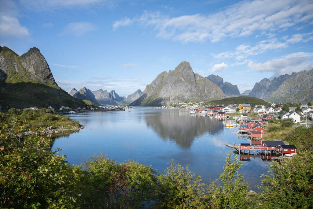
Reinehalsen Viewpoint
Reinehalsen at sunset
Lastly, do not forget the classic photo from the Reinehalsen viewpoint. It’s just right under Reinebringen and you’ll pass by it.It’s where you can get this view:
Map of the Reinbringen Hike on the Lofoten Islands
Here is the map of the hike. If you need a GPS track, you can download the .GPX file from the Komoot activity.
Note: I took the old trail by mistake on the way up. Please don’t go there as you’ll end up in a tangled mess of branches like I did :). Proceed further south to the start of the stairway.
Where to stay nearby the Reinebringen Hike
A quick note on camping: it is no longer allowed to camp there. You can camp anywhere else in the surrounding mountains within the Allemannsretten regulation. Here is a good map showing where you can camp and where not.
However, If you have a camper or a van, you may also stay overnight at the Ytre Haven parking.
Otherwise, you will find cabins on the Reinefjord or private apartments for rent. Accommodations are also available in Sørvågen or Å.
Additional resources
- Planning a trip? Here are my tips to plan a trip to the Lofoten Islands.
- You may also want to check out the Veinestinden Hike, and Munken, which are relatively close.
- Check out the main page on Hiking in Norway for more Hikes and inspiration.


Hello Marco! I feel very fortunate that I have found your webpage of astonishingly beautiful photos and information. We will be in the Lofton Islands 6/30-7/10. We have 2 days on Senja Island and have our hikes planned there.
While on Lofton, are there best hikes you would recommend for late evening, such as 10:00 pm or midnight. I’m looking to capture the light from midnight sun. Thank You Marco! All ther best and keep on hiking friend! Cheers, Kathryn
Hi Kathryn! Thank you so much; I’m glad you enjoyed the content! I’d personally choose between Offersøykammen, Stornapptinden, Volandstinden, Flakstadtinden, or Veggen. They all offer great views of the coastline. Have a great trip!!