Hike to Skageflå and Geirangerfjord Viewpoint, Norway
The Hike to the Beautiful, abandoned Skageflå farm on the mountains above Geiranger is one of the most popular among tourists in Norway. It’s easy to see why; the view of the picturesque farm with the fjord and Seven Sisters waterfalls in the background could not be more picture-perfect than it already is. Geirangerfjord is a UNESCO World Heritage site after all, and for good reasons; the scenery is spectacular.
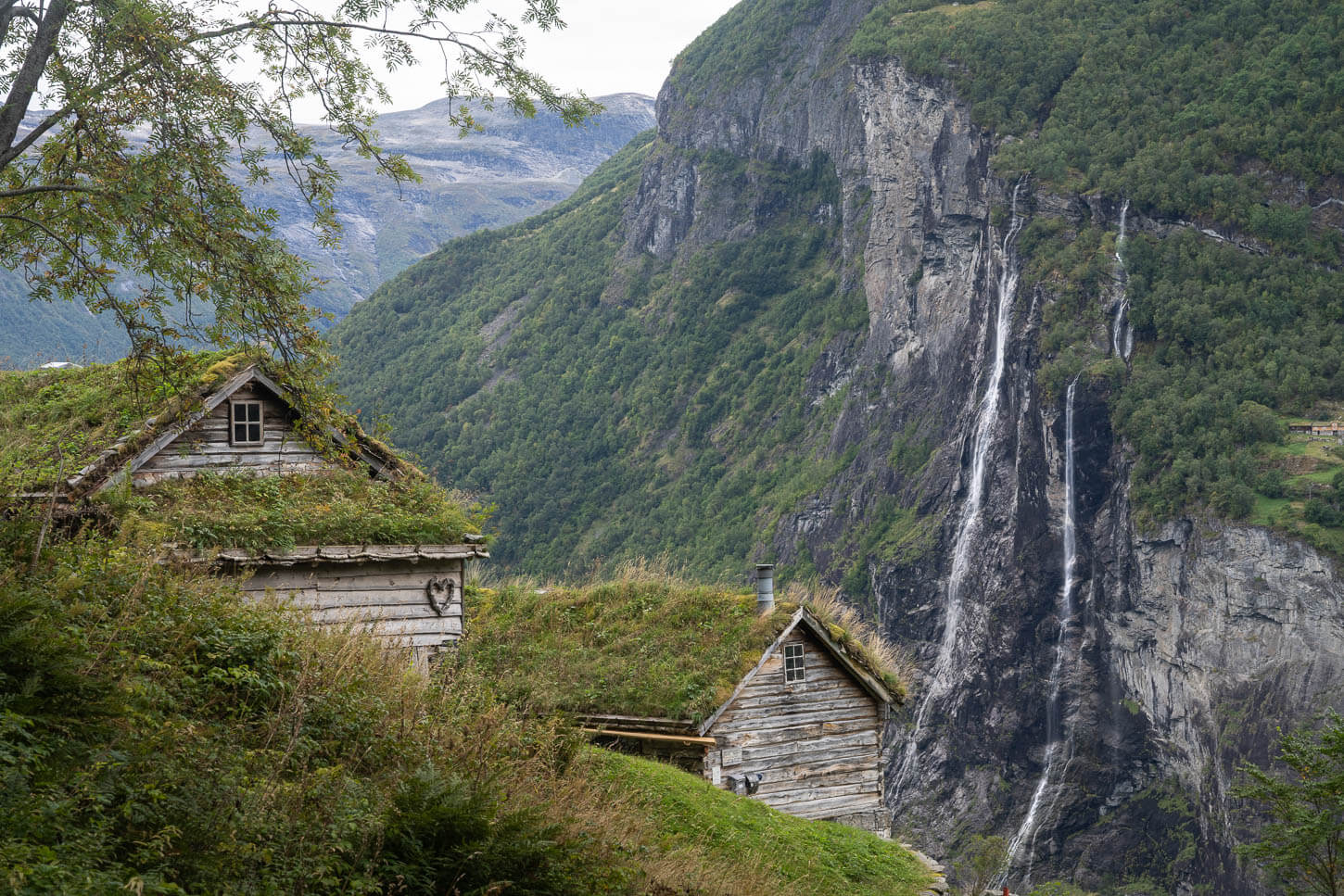
Skageflå Farm with the Seven Sisters Waterfall in the Background.
The view of the Geirangerfjord from Skageflå is also worth the hike in itself. It’s hard to render how big the fjord really is, and one has to see it “live” to really feel that. Especially when the boat passes through, and everything is put into scale. It is also likely the most famous “cruise ship fjord” in the world. At least, apart from being total eyesores, such ships can help give an idea of the true size of the fjord.

Also, the Skageflå is a place where farmers actually lived and cultivated the land. Yet, while the trail to get there is steep and not too difficult, it’s hard to imagine how, once, people could do this routinely, whether they reached the farm from the sea or by using the trail on the mountainside.
Nowadays, however, the Skageflå farm is only abandoned in the sense that it no longer serves as a farm, but the land is still privately owned, and the huts are maintained.

To hike to the Skageflå farm, you essentially have two options: either by boat, as a one-way hike, or you can do it as an out-and-back hike from Geiranger. I did the latter, so I’ll describe the hike as such, but I’ll also share the information you’d need to do it as a one-way hike using the boat transportation service.
Table of Contents
Overview of the Hike to Skageflå & Map
As mentioned in the intro, you can do the Skageflå Farm Hike either as an out-and-back hike from Geiranger (13.6KM for about 4:30-/5:30 hours) or as a one-way hike by taking the boat to Skagehola. Skagehola is the small dock in the fjord below the farm, and then hiking your way back to Geiranger (6.3KM for about 3:30-4:30 Hours).
While the hike is shorter if you take the boat, you still need to go through some exposed sections and steep climbs to get back to Geiranger. A third option, if you want to visit without going back to Geiranger, is to take the boat to and from Skagehola. In this case, you only need to hike from Skagehola to Skageflå and back, which takes about 30-45 minutes each way.
If you prefer to take the boat, you should book your spot in advance. Regardless of which one you choose, the trail is quite steep in places, and the elevation gain isn’t negligible for such a short hike.
| Max Altitude | 540m |
|---|---|
| Distance | 13.6KM |
| Elevation gain | 900m ↑ / 900m ↓ |
| Hike time | 04:30/ 05:30 Hours |
| Hike Difficulty | Moderate, but with some exposed sections |
Here is the map of the hike. You can download the GXP file for free from the activity linked below.
How to get to the Skageflå Farm trailhead and Parking
There are a number of ways you can get to Geiranger. If you are planning to drive there, be aware that the roads around there are narrow, one-lane roads, where you may find buses coming from the opposite way. It’s not a difficult drive per se, just take your time and watch well ahead of you and either up/down the mountain for oncoming traffic.
- Driving Directions: You can get to Geiranger via Road 63, either from the east or from the west. It’s a scenic drive, like most in Norway. Getting there from major towns like Oslo or Bergen requires more than 7 hours one way. The closest Airport would be Ålesund, and the driver from there is less than three hours.
- Parking: If you plan to park in Geiranger, be prepared for a substantial parking fee. If you are travelling with a tent or in a Van/Camper and are planning to spend the night in Geiranger, you may want to go to the Geiranger campsite first. However, you can either park by the ferry dock or drive further for a couple of kilometers on a narrow-single lane road to a smaller paid parking spot closer to the actual trailhead. There is also an official, dedicated site about parking in Geiranger, with an overview of all the other parking spots available around town.
- Public Transport: without a car, you could either book a tour, or you can also take a boat ride from Ålesund to Geiranger. In summer, you can take the ferry from Hellesylt.

Geiranger, Parking by the ferry dock.
The Skageflå Farm Hiking Trail
I parked at the ferry dock first, two kilometers or so, it’s a walk partly on flat, paved ground and partly on Gravel. From Geiranger, you will first reach a smaller conglomerate of houses called Homlung. This is where the hiking trail starts. The trailhead is shared with a few more trails, all of them mentioned on the info board that can be found at this location.
The trail is rather steep for the first few hundred meters, partly on flat rocks and partly on packed dirt. Both are quite slippery in case of rain or when it’s wet. Gradually, the views open up toward Geiranger and the ferry dock, before the trail enters the forest after about 2 KM into the hike from Geiranger.

Geiranger.

View from the steep trail to Skageflå.
From here onwards, not much of a view. The trail continues through the forest until it reaches another farm you will find on the way. The farm is called Homlungsætra, and this is also the highest point on the hike. Homlungsætra is also a very nice location, and so are the abandoned farm buildings.
There are also a couple of nice viewpoints above Girangerfjord here, both completely exposed.

Homlungsætra, another abandoned farm on the way to Skageflå.

Geirangerfjord viewpoint from Homlungsætra.
The trail then continues through the forest before reaching the point where it steeply descends toward the abandoned Skageflå Farm. Here is also where you will find the most exposed sections on this trail. There are some ropes and cables in place to help with the balance, but you do need to be careful here.
At the end of this section, the trail becomes less steep until it reaches the farm. It’s possible to walk all around the building, and it looks like a well-maintained garden, also furnished with a picnic table. The Farm buildings are, of course, closed as this is private property, so it’s not possible to visit them.

Exposed section on the way to (or from) Skageflå. The abandoned farm is visible below.

Approaching the farm through the forest.


Skageflå with the Seven Sisters, which were only two and a bit on this occasion, in the background.
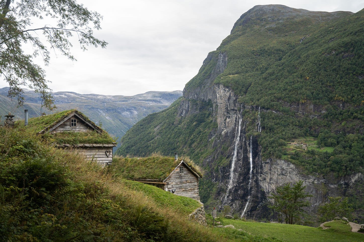
You can also walk all across the lawn and enjoy the views of the gigantic Geirangerfjord from the top of the cliffs below the farm. It is a spectacular view of the fjord from from there, and that is even more apparent when small boats cross the fjord.


Skageflå Farm Photos and Photography Tips
The Skageflå Farm with the view of the Seven Sisters waterfall is one of the most famous photo spots in Norway. It is like a fairy tale view, so it’s easy to see why it is so popular. It’s one of those places that looks like it’s straight out a fantasy novel. Or, one of those places where time seem to have stopped.
From a landscape photography point of view, i think the best viewpoint is right next to the trail, where you can get a view of both the farm and the Seven Sisters waterfalls. This photo spot by the Skageflå farm is right next to the trail in the weeds to its right.
Skageflå Farm with the Seven Sisters Waterfall in the Background.
While you don’t get a view of the whole fjord from there, you can walk across the lawn right below the farm, and toward the cliff. There’s where you have the best views of Geirangerfjrod. However, i think the view of the fjord from Homlungsætra is a little more photogenic, so don;t miss that.
View of Geirangerfjord from Homlungsætra
This location does not get much light as it is rather deep down below towering mountains, but if i had to choose between sunrise and sunset I would go for sunset, since the viewpoint faces the west.
If found a 24-70mmm lenses (full frame) to be more than adequate for this location. All the photos in this post were taken using that range.
Last note: if you want to photograph the Seven Sisters, you should probably plan to do this hike early in the season. That would be between May and July. In other months, the water volume going through the falls will be quite low, so the falls won’t be nearly as spectacular. When I visited in mid-September, there were probably about two and a half of the Seven Sisters :). That was also after a few days of rain too.
Where to stay
There are quite a few hotels, guesthouses, and similar types of accommodations in Geiranger. You should book well in advance if you are planning to spend the night in Geiranger, anywhere from May to September.
For Van or RVs, it’s best to head directly to the Geiranger Campsite if you wish to spend the night there, so you don’t have to pay for parking in Geiranger.
Additional Resources
- Check out more Hikes in Norway, with Maps!


Very, very nice!!! We were in Oslo this summer and took the train to Bergen, then a cruise up the Sognafjord. I’d love to visit the Abandoned Farm, too.
Thanks Anika! Nice, sounds like a great trip, The Fjords in western Norway are truly spectacular!