Raudibotn, a Gem in the Highlands of Iceland
The Extinct volcanic crater of Raudibotn is a gem of rare beauty in the Highlands of Iceland.
This is one of my favorite locations in Iceland; if you can make it here, it will probably become one of yours too.
The contrasts and colors here are of otherworldly beauty. It is one of those locations you may think no one could have done any better if they tried to invent it.
As only in Iceland can happen, you feel as if the earth was alive. You will feel the forces that created this beautiful landscape.
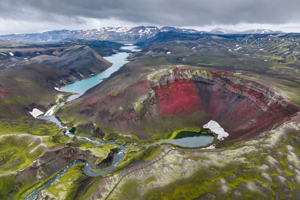
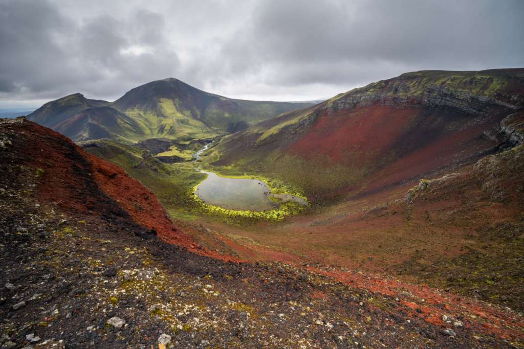
Drone Shot of Raudibotn and Holmsarlon, the big blue lake in the background.
Getting to this beautiful gem in the Highlands is relatively easy, despite its remote location. You will need a 4X4 vehicle; a Dacia Duster or similar is ok. There are a couple of small creek crossings on the way, though They should be doable, don’t forget to check the water levels before crossing them.
The drive is relatively long as it will take almost an hour from road F208 south. Also, the road is rough in places, but the scenery along the way is fantastic.
Once you reach the parking spot, the Hike to Raudibotn will take about an hour. If you plan to visit this location, I recommend accounting for an entire half-day.
Ready? Let’s go!
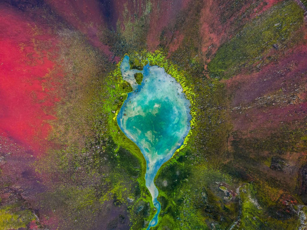
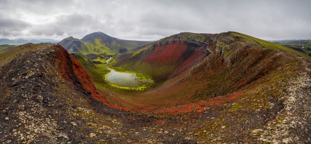
Drone Shot of the small lake in the middle of the Raudibotn crater
How to Get to Rauðibotn & Outline of the Hike
- How to get to Raudibotn: From the Ring Road, you turn onto Road 208. Keep going straight until you turn to the left onto Road 210. Eventually, Road 210 will become Road F210. Follow the road until you reach the parking spot, just by the Holmsa River, which you should not attempt to cross. The drive from the Ring Road will take about 45 minutes to an hour. A bumpy ride in some stretches for smaller 4WD vehicles, like the Duster I rented. If you are looking for car rental options, I can definitely recommend Blue Car Rental (with 5% discount) for cars and CampEasy for Camper Vans.
- Start of the Hike: You can leave the car at the starting point of the hike, or, depending on water levels, you can proceed along the same path with the vehicle until you reach another parking location up a small hill. It will cut about 10 minutes from the hike if you can park there. Check the water levels before crossing!
- Photography & Scenery value: Compulsive shooting; you may not want to leave this location once you get there.
- Difficulty: easy. There is little height difference, and the trail is neither steep nor on rugged terrain.
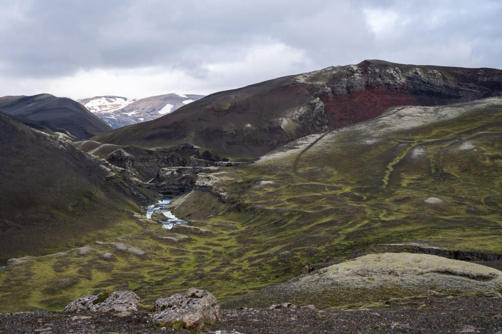
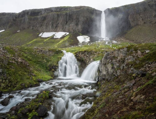
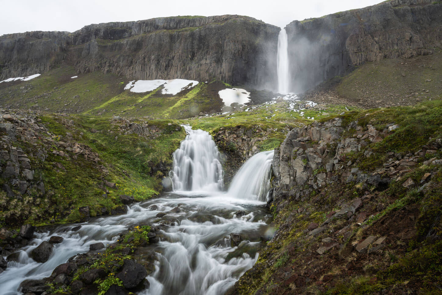
- Tip: The Axlafoss waterfall is close by and definitely worth visiting for a photographic stop.
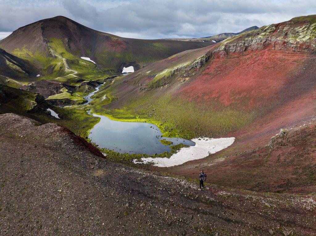
The crater viewed from its rim.
The Rauðibotn Trail
| Distance | Elevation Gain | Hike Time |
|---|---|---|
| 7.31 KM | 230 MT | 2.30/3.30 hrs |
The crater is not visible from the parking spot, but you will easily find the trail heading up a small hill. Unfortunately, there are also some quad tracks; if possible, avoid them and follow the trail. The Natural environment here is very pristine but also fragile.
The magnificent views will slowly reveal themselves as you reach the top of the first hill. The crater, the waterfalls of the Hólmsá, the blue waters of Hólmsárlón and Mount Maelifell across the black sand plains.
View from the trail towards Holmsarlon. The trail leading up to the crater is on the right. That is the crater’s rim.
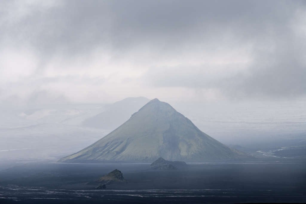
The sub-glacial volcanic Mountain Maelifell
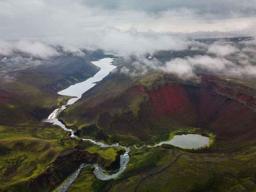
View over the Raudibotn crater and Holmsarlon
As you continue, the trail will gently go down the slope; you can either go ahead towards the waterfalls and Hólmsárlón or turn right towards the top of the crater.
I’d also recommend hiking around this area and the Holmsa River if you have time. It’s a magnificent location with several waterfalls; generally, the site is worth exploring.
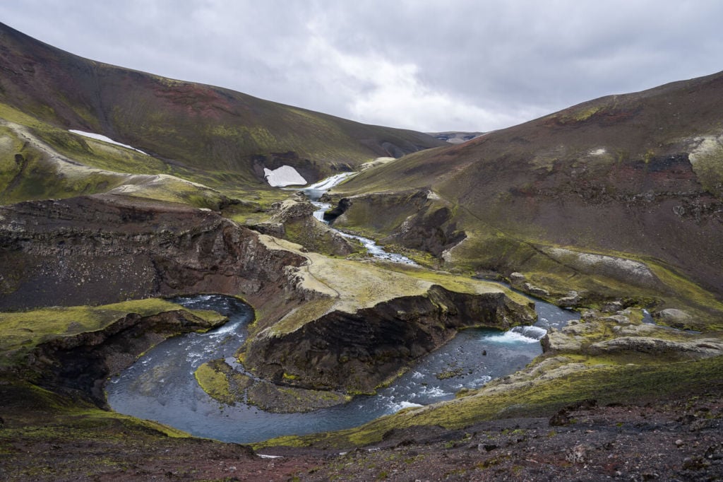
Small Horshoe bend by the Holmsa River.
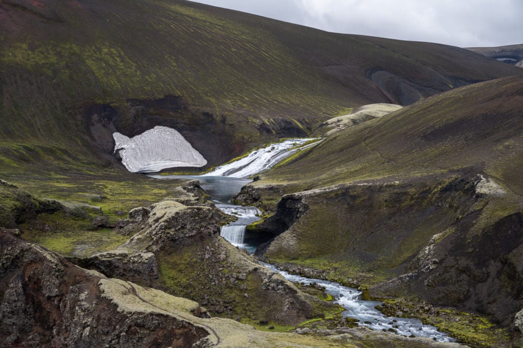
Part of the Hólmsárfossar waterfall, in the background.
Next, you can continue up the Crater’s Rim to the top.
At the end of the hike, the top of the crater is also where you will have the best view over this Gem in the highlands and the surrounding landscape.
Photos and Photography Tips for Rauðibotn, a gem in the Highlands
Here’s a drone clip to give you an idea of the scale and photographic opportunities this location has to offer:
From the ground, the best vistas are from the top of the crater at the end of the hike, but the most photogenic vantage points are on the way up.
You will have the best views over the small lake inside, along the crater ridge. As you walk your way up, several spots will suit panoramic composition; the crater is way bigger than it looks in photos, and if you want to capture as many views as possible, a panorama is the way to go.
Single frame at 14mm
Panorama made with four vertical frames at 14mm.
If you have a drone, the compositional possibilities are your disposal are virtually endless. Not only in terms of Classical landscape photography but also Abstract photos are possible here due to the colours and contrasts of the volcanic terrain.
With a drone, you can take photos from every possible angle.

Drone Shot of the crater, looking towards East/East-SouthEast.
The location can be shot in any weather. When overcast, it makes for excellent moody images and a nice contrast with the colourful layers of the crater.
When sunny, the colours of the crater will pop out even more. I would avoid the harsh sunlight of the middle of the day in the central summer months if going there for photos only, but either way, you will visit a fantastic wonder and bring back memories you will cherish for a long time. Raudibotn really is a hidden gem in the Highlands.
Map of the Rauðibotn Hike:
Here is the map of the hike. If you need a GPS track, you can download the .GPX file from the Komoot activity.
Where to stay near Raudibotn, a Gem in the Highlands
There are a few options not too far from this location that are worth staying at, especially if you plan to explore the highlands further. The accommodations are either huts with shared dorms or camping grounds (except the Snaebyli Cottage):
- Strútur Hut on road F232, which is on the Right of road F210 when coming from East. Please note getting there from Raudibotn requires crossing the Holmsa River (the same one close to the parking spot), which may require a large 4WD.
- Álftavötn hut, on road F233, which requires a large 4WD. There is also a river to cross. Do not attempt unless you drive a large 4WD and have experience crossing rivers.
- Hólaskjól-Higlandcenter on road F208. Be careful not to take road F233. I recommend avoiding that road unless you know what you are getting into, as it has a rather dangerous river crossing. Instead, you should go back to the crossroad between Road 210 and 208 and continue from there.
- Snaebyli Cottage on Road F210, close to where it changes into Road 201
Additional Resources
- Check out more Photo Hikes in Iceland here
- If you enjoyed this crater as I did, you will most likely enjoy Rauðaskál.
Car or Camper Van Rentals
I can definitely recommend two companies here:
- Cars: Blue Car Rental, which is the largest Car rental company in Iceland, and for good reasons. Free Cancellation, Unlimited mileage, 24-hour break assistance, SCDW, CDW, TP, and GP insurance are included in the price. Blue Car Rental is also located within walking distance of the Keflavik Airport, so you can be on your way to explore Iceland right away. I’ve always been happy with my rentals there, which is why I’m happy to recommend their services here on my blog.
- Camper Vans: CampEasy. With CampEasy, you can rent 2WD or 4×4 campers alike. With a raised Chassis, larger tires, and extra insurance with reduced liability for river crossing, their 4X4 campers are the best choice for your trip into the Highlands. Their Website also provides extensive information about roads you can take and instructions on river crossings. Perfect choice for a hiking holiday in the highlands!
These are my two favorite companies in each respective rental area, which I why I am happy to recommend both here. If you also like this blog, booking through them is a great way to support it. I’ll get a small commission fee at no additional cost, so you can essentially support the running costs of this blog for free too.


Hi. Have you attempted hiking the lakes? I’d like to do this if able to cross the water
I have not, perhaps this year. Can’t tell if there is a way to cross the river from that side safely. I’d attempt it from the other side directly via Road F232.
Hello,
Between the 2 parking possibilities there is a water to cross. I don’t read in your description how that has to be crossed if we park at the first parking spot and cross that water on foot. Do we need to take of our shoes or not? If so, then we might need some kind of surf shoes if the bottom of that stream is rocky?
Thank you!
Hi Ronald,
Yes, each time I visited I drove to the upper parking area and never crossed on foot, so it’s a good question. As far as I remember, it’s too deep not to get your feet wet; it was 1/3 or half a shin deep. The bottom isn’t particularly rocky.
Hi Marco – fantastic site, and hugely helpful content. I really appreciate the consistency in format between the hikes – makes comparisons really easy.
I am heading to Iceland mid-September – and we are looking to do the Raudibotn hike. I am slightly nervous of the drive from the Southern Ring Road on F210….
Is the first car parking spot ‘obvious’ when you get to it? I think you say you will need to cross the water on foot if you stop at the first – but not too deep? I am planning on hiring a Kia Sorrento – which is one of the larger ‘City SUV’s’ – do you think this would be OK for the crossing of that ‘river’ to the second car park?
Hi Neal,
Thanks, glad you appreciate the format! Yes, it is rather obvious, as it will be before the Holmsa river, the road widens there. I parked there the first time I visited in a Duster and crossed it on foot upstream without getting wet. Whether it’s crossable or not will entirely depend on water levels. This year, water levels have been unusually high in the area, so much so that road F210 from the east has been closed at the Junction with Road F233 for a while now. So keep an eye on https://umferdin.is/en to see how it progresses. The first two smaller river crossings were also higher this year compared to previous years, but I think they were still easily doable. Take your time and assess each river before trying to cross, and attempt it on foot first if you’re not sure.
Anyway, hopefully the area will be reopened by then, wish you a great trip regardless!
Thank you Marco – really appreciate your response. Looking at the map, the closure looks to be to the West of the Holmsa river – which I would not be crossing anyway – but those first 2 ‘smaller’ crossings will still be a concern.
It doesn’t look too far if I were to instead park at the junction of the F233 – perhaps an extra 2km return.
Do you think access to Axlafoss will be similarly affected if coming from the 210 as I had both on my list for this day!
Thanks again :-)
HI Neal, yes it’s not too far. it’s the same for Axlafoss indeed, as it’s very close to the intersection with road F233 (less than 10 minutes by car). Best of luck with the trip!!
Hi Marco – did the trip on Weds 17th. Weather was fantastic. Blue skies and no wind!
Your directions were spot on, although it is now FOUR crossings – so another stream of water must have popped up.
I was upgraded to a Landrover Defender – so felt quite invincible on the F210 and on the F208 – it was an incredibly capable machine that soaked up everything those 2 roads had to offer.
One of the crossings was quite deep – I would say maybe close to 1m, so I looked up and down, and found a spot maybe 50m up that looked far better – and was able to cross easily some other tracks suggested I wasn’t the first. When I got out to check that particular crossing, there was a number plate in the bottom of the water – suggesting that someone may have tried and failed!
The location is spectacular, and the only thing we did slightly differently is to follow the ‘track’ to the furthest side of the crater first (to the far waterfall by the lake), we made our way up that side of the crater, and worked our way back along the ridge.
We took a wrong turn on the way back (right at the beginning) and found ourselves on F233. After about 15mins we realised this was a very different road to F210! The sat Nav then regained signal, and said that although longer, we could still go that way….. Well, should have followed my instinct and turned back. This road was a test even for the Defender – we did a further 5 river crossings until eventually we got to a river that we just couldn’t consider attempting – it was in full flow, deep, and about 50-80m across…. so we had to turn back. The road conditions on the F233 were far far tougher than the F210 or F208 – and for anyone reading this, I would avoid even if in a specialist vehicle – the inclines, ruts, and narrow width of the road were pretty challenging.
Iceland is pretty crowded at the moment, with all the main sites over-run with coaches and tourists, but for 7 hours on that day, we did not see another human being – BLISS!
Thanks again for your comprehensive guide – I would not have even contemplated doing this journey without your insight :-)
Thanks for reporting back Neale! Glad you made it there too. Interesting about the additional river crossing, I could not go there myself as the road was closed, and one of the things they mentioned was that the riverbeds had changed. So that may be what happened.
Good call on turning back at that river on F233. That’s a river crossing with big rocks hidden under the water.