
The Best Waterfall Hikes and Walks in Iceland – A Practical eBook Guide
The Best Waterfall Hikes and Walks in Iceland is a practical eBook guide for discovering the island’s most beautiful waterfalls. I wrote this book out of my deep passion for Iceland—the land of fire, ice, and Waterfalls. It is the culmination of over a decade of on-the-ground exploration, four years in the making, and designed to be both a tribute to their beauty and one of the most complete resources on the topic. In the book, you’ll find a total of 173 waterfalls along 102 hikes and walks, all with maps and trail gradings.
From iconic locations like Skógafoss and Dynjandi to remote Highland waterfalls such as Dynkur and Lambhagafoss, this guide helps you find, reach, and plan waterfall hikes and walks across the country. All around the Ring Road and deep in the Highlands.

This Book, rather than being a simple list of “top waterfalls,” focuses on how to get there, what the hike is like, and how to plan your itinerary efficiently. It’s designed as a travel tool: helping you choose what to visit, what to skip, what kind of vehicle you need, and what skills are required on the trail.
The guide follows a logical, counter-clockwise itinerary around Iceland’s Ring Road, making it easy to integrate waterfalls into your trip planning—whether you’re driving the full loop or exploring one region at a time.
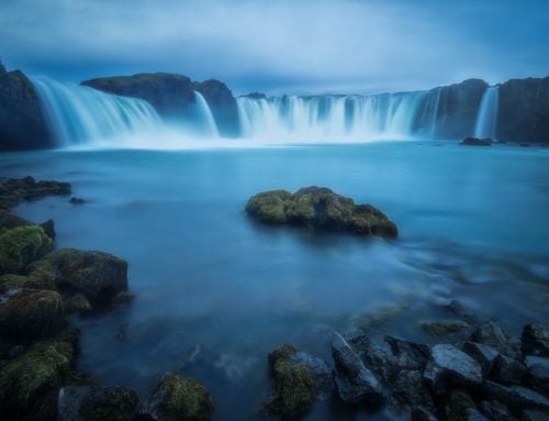
View the Photo Gallery with some of the most beautiful Waterfalls in the Book and and Download a free Sample (Intro and one full waterfall)


Get the Guide Here for a launch price of 17.99 €
Who This Guide Is For
This guide is for anyone planning a trip to Iceland who wants more than just roadside viewpoints.
It’s made for:
-
Anyone driving the Ring Road (Route 1)
-
Hikers looking for scenic walks and longer hikes
-
Landscape photographers searching for scenic waterfalls
-
Travellers who want both famous and lesser-known waterfalls
The book works both as a full Ring Road itinerary companion and as a regional guide, so you can focus on areas like the South Coast, East Iceland, North Iceland, or the Highlands individually.
Regions covered with the number of Hikes and Walks for each location, in order: “Extended” version of the Golden Circle (10), the South Coast (25), East Iceland (22), North Iceland (12), the Westfjords (6), the Snaefellsnes Peninsula (5), West Iceland (6), the Highlands (19), and Reykjanes (1).
From short, easy walks to demanding full-day hikes, this guide helps you plan your time realistically and discover waterfalls that match your interests, skills, and schedule.
If you want to see Iceland’s classic waterfalls and escape the crowds to find hidden ones, this guide is built for you.

Map with all the waterfalls in the Guide. All the maps in this book are based on open data from the Icelandic Institute of Nature Research, www.natt.is.
What You’ll Find Inside
Inside the guide, you’ll find:
-
103 hikes and walks
-
172 unique waterfalls
-
428 photographs
-
32 downloadable GPX tracks for the most remote locations*
Each hike includes practical information to help you make informed decisions, including:
-
Distance and elevation gain
-
Estimated hiking time
-
Difficulty level
-
Recommended season
-
Vehicle requirements
-
Clear route descriptions
The book is organized around a counter-clockwise Ring Road journey (Route 1), but waterfalls are also grouped by region, so you can easily plan day trips or regional itineraries.
It’s designed both for trip planning at home and for field use while traveling.

Features at a Glance
-
Waterfall hikes organized by region
-
Clear route descriptions and trail guidance
-
Difficulty ratings and time estimates
-
Seasonal access notes
-
Vehicle recommendations
-
Hand-drawn topo maps for quick orientation
-
GPX files for some of the hardest-to-find locations
The guide comes in two formats:
-
Uncompressed version (1.7GB) for desktop use
-
Compressed version (49MB) optimized for mobile devices
Download the Guide
Discover Iceland’s waterfalls with confidence, depth, and flexibility.
👉 Get the Guide Here:
*GPX files included for: Aldeyjarfoss, Bassi Waterfall & Gufufoss, Benefoss, Ankafoss and Attifoss, Bergárfoss (North Iceland), Dettifoss East, Dynjandi, Dynkur, Flögufoss, Fossárdalur and Múlafoss, Glymur Waterfall Hike, Gullfoss East, Háifoss, Hangandifoss and Múlafoss, Hengifoss, Huldufoss, Húsárfoss, Rjúkandafoss and Hvalárfoss, Ketubjörg Cliffs and Waterfalls, Klifbrekkufossar, Lambhagafoss, Laugarfell Waterfall Circle, Möngufoss, Morsárfoss–Kristinartindar, Núpsárfoss and Hvitárfoss, Nýifoss, Ófærufoss, Rauðfoss, Rauðsgil, Skógafoss and the Waterfall Way Hike, Stakkholtsgjá, Strútsfoss, Valagil, Vestdalsfossar.





This book is absolutely fantastic. An essential guide if you want to visit Island.Very detailed route descriptions with wonderful photos. I recommend it.
Hi Marco, What is the uncompressed book format? The one that is 1.7 GB. Is it PDF like the free sample or EPUB, KPF, etc?
Best,
Yuri
Hi Yuri, both are PDF files. Cheers.
Thanks! I got it. One question I keep asking is, what’s the name of the waterfall near Hangandifoss? If you stand on the cliff opposite Hangandifoss facing Mulafoss, this beautiful waterfall is on your left. It is located on that creek you need to cross earlier before you get to the cliff. This waterfall is not shown on any maps I’ve seen and you do not even mention it in your chapter. Why? Is it seasonal? We saw it last October.
Thanks, Yuri. Yes, that waterfall has no official name, and I am not aware of any colloquial name either. I have only seen it with a substantial amount of water once in late spring.
One tip on names and places – you can look them up on Iceland’s SDI map here: https://kortagluggi.is/mapview/?app=kort; switch to English and search for “names” in the search bar on the left, and select “geographical names”.
Thank you, this map is quite helpful.
Yuri
Hi Marco,
This is me again. In your description of Kirkjufellsfoss, you state that ” From Grundarfjörður, continue along Road 54 past the town until you reach Kirkjufell. The waterfalls are visible on the right. Keep driving until you reach the large parking area on the right-hand side, which is the main access point.”
However, google maps shows me that driving from Grundarfjordur on Rd 54 (that is, going west) the waterfalls must be on my left and so is the parking lot at 64.92792, -23.31339. Am I wrong or this was your misprint?
Thanks,
Yuri
Hi Yuri, you are right, thanks for pointing that out. I guess it’s a case of typo blindness after having re-read the content several times. I am working on a few typo corrections, and I’ll address that too. Thanks!