Otervika Beach Hike, A Beautiful Hidden Beach, Andøya, Norway
Otervika is a beautiful, hidden beach you can only hike to on the Island of Andøya, in the far North of Norway. A dreamy landscape, with a white beach enclosed by the amazing rock formations of Andøya’s coastline.
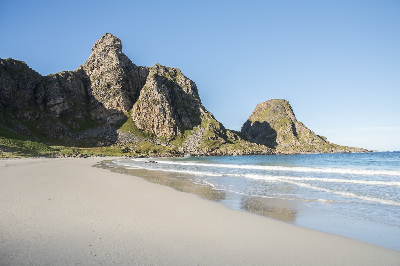
Otervika beach
This beach probably is just as beautiful as it is difficult to get to. It’s a place not many visit, also because it is a rather difficult hike to get there. The coastal trail that connects to the beach is only accessible at low tide and, even then, it’s not a walk in the park.
Also. while technically it’s an out-and-back trail, I will argue it’s worth making it a loop hike and including Måtind in the loop. It’s a longer hike, but if you were planning to visit Måtind and this beach, it makes sense to combine them into one. If you can match the low tide :)!

No signs of other visitors when I was there.

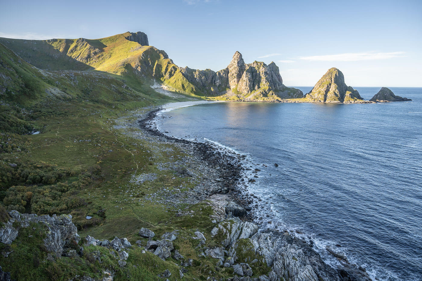
Otervika from above. Måtind, visible on the upper right can also be included in this loop hike.
Table of Contents
Overview of the Otervika Beach Hike & Map
The hike to Otervika can be done as an out-and back-hike- or as a loop. If you want to do it as an out-and-back hike, the length of the trail is about 6km each way via the sketchy coastal trail, while it’s 10km each way with about 800m total elevation gain if you hike by the mountains.
I’d recommend the loop variant especially if you are planning to visit Måtind. It’s longer, but that avoids the sketchy coastal trail on the rocks.
Safety note: do not attempt the coastal trail hike at high tide or in bad weather. The trail will likely be underwater at high tide. Be sure to check the tide levels before trying to get there.

There are several narrow, slippery, and exposed passages along the coastal section of the trail. Attempt only at low tide.
Also, an additional note on the total length and elevation gain is in the table below. I started the hike at the Middnatsol campsite, but you can actually drive for the two km that separate the campsite from the actual trailhead. So you can shove off 4 Km from the total distance, f you are. Likewise, the elevation gain will be limited if you do not include the climb to
| Max Altitude | 560 m |
|---|---|
| Distance | 16. 1 KM |
| Elevation gain | 730m ↑ / 730m ↓ |
| Hike time | 05:00/ 06:30 Hours |
| Hike Difficulty | Hard/Exposed |
Here is the map of the hike to Otervika beach. You can also download the GPX file for free from the activity linked below.
How to get to the Otervika Beach trailhead and Parking
You can reach Andøya by either Car or Ferry. It’s a bit of a drive, regardless. The trail is located in the small town of Bleik, specifically its southern part.
- Driving Directions: if you are coming from the north (Tromso/Senja), the most efficient way to get there is by taking the ferry between Andenes/Gryllefjord. The ferry runs two times a day in summer. You can also drive. From Senja, it takes about 4-6 hours. It is a scenic drive, so if you prefer it to the ferry, it is worth it. I did both on different occasions and really enjoyed the drive. If you are coming from the south, then you can only drive. It takes about 4/5 hours from Narvik, and about 3/4 from Svolvær, just to give an example. Once you have arrived in Andøya, follow the directions to Andenes, then to Bleik.
- Parking: free parking is available by the trailhead, here. It’s a dirt road, but easily accessible in any 2WD car.
- Public Transport: Buses 874 /883 Stop in Bleik. You can check the timetable here.

You’ll find some parking spaces at the end of this coastal road south of Bleik.
The Otervika Beach Hiking Trail
At the trailhead by the beach, the trail looks easy enough. Because you don’t see what awaits behind the cliffs. Even then, initially, it’s just a rather easy hike on the rocks along the shore.
With its paradisiac look, it’s hard to imagine how difficult the trail ahead could be. However, as you lea ve the trailhead, the trail progressively gets more difficult.


Otervika Beach Trailhead
PSA: I’ll repeat it here again for those who skipped this section: this is a hike that should not be attempted at high tide. Chances are you’re going to fall into the seas or be hit by a wave, with no easy way to get back up. That means serious hypothermia risk.
Now back to the trail: soon enough you’ll find yourself scrambling up and down the coastline, and then the most difficult part starts. Carefully look for the pink trail marks painted on the rocks. Viable passages are restricted to a few spots in places.
The good guys that painted the trailmarks even draw where to put your hand and how, and where to put your foot in places.

The trail soon turns into an exposed hike on the rocks.

Some sections involve scrambling up steep rock faces with minimal support, but with the aid of ropes sometimes.

In some other exposed sections, passages are restricted to a few, narrow points. Here you can see a hand on the left and another mark for the positioning of the foot.
You’ll have to walk on narrow, slippery rocks in other sections. Take your time to assess the proper route. Then, at some point, the beach comes into sight. Here, you may notice a trail to your left, heading up the mountain. A narrow passage to your right, down by the sea.
Amazing Viewpoint of Otervika beach from a dead-end deviation above the trail.
You may be tempted to take the upper trail—I did. It leads to a rather beautiful viewpoint, but you’ll have to backtrack to get to the beach. There is seemingly no safe passage up there, so you have to cross the last narrow passage by the sea.
Once you pass this one, too, it will be an easy stroll to the beach. At the trail forks, keep right to get to the beach. You can walk across it all the way to the other side

Last exposed section of the trail.

The last part is flat.

The northern part of the back is rocky

The southern part is a large, white sand beach.

View opposite to the trailhead.
From Otervika to Måtind
Now from the Otervika beach you either have the chance to take the same route back, or you can also hike up the side of the mountain, and either get to Måtind first (up to your right) or go directly back to the trailhead via Nonstind (up to your left).

Another trail connects Otervika beach to Matind.

The trail is steep, but always offers amazing views of the beach.
If you have never been to Måtind I’d recommend going there. it’s awesome. it takes about 20 minutes extra, one way. If you have already been to Måtind, I’d still recommend going there. It’ll still be awesome. That’s what I did too, and can confirm it was.
Jokes aside, it’s worth it if you have the time. You can climb up to Måtind from the far side of the beach, opposite where you came from. The climb is on a steep gradient, so it’s kind of slow going, but other than that, it does not require scrambling, and there are no exposed sections.
You’ll then reach a plateau when the trail connects to the Baugtua trail. From there, it takes about 20 minutes to reach Måtind’s summit.

Summit of Matind.

From Måtind back to the Otervika Beach Trailhead (via Nonstind)
Once you’ve soaked in the views, and rested a little you can start the descent. Initially, you can follow the same trail that leads you to the top, but be aware there are several trail crossing paths on the plateau. One leading to Stave, one to Baugtua, and another to Nonstind. You’d have to follow the latter to get back to the trailhead.
Basically, keep to the left except for the trail that leads back down to Otervika. There’s a little more elevation gain to reach Nonstind, but it does not take long to get there. From here, too, you’ll enjoy fantastic views of Otervika Beach.
View from Nonstind.
The trail continies on a plateau.
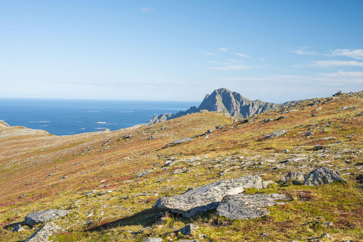
You can then continue to follow the crest until you find yourself on the other side of the mountain, where the views will open up to the Bleikmorenen nature preserve and Bleik. Again, there are fantastic views in that direction, too.
From here it’s a moderately steep walk downhill. First on the side of the mountain and then through a small birch forest, at the end of which you’ll find yourself back at the trailhead.

The final part descends back toward the trailhead.
Otervika Beach Photos and Photography Tips
Generally speaking, the landscape is amazing all along the trail. I took many shots and had a hard time coming up with a reduced number for the post.
The beach is mostly in the shade in the morning.
Otervika Beach would make for a great sunset or midnight sun hike. I would have loved to do it for sunset, but I could not get the tide/weather/elements to come together while I visited. So I guess I’ll keep that for another visit, whenever that will be. It would be an epic view to see this beach in the warm late afternoon light.
So, getting there for sunset does require some planning and some luck, matching the tide with the weather.
The beach faces west, so it does not get much light early in the morning. It starts to get some before noon, and that’s when the colors of the sand and the sea start to shine.

The beach starts to be fully lit around or after noon.
The beach is beautiful from every angle, and there are plenty of rocks that can be used for the foreground. This applies to both the trail and the beach. You have several great spots on the trail by the coast and on the beach itself.
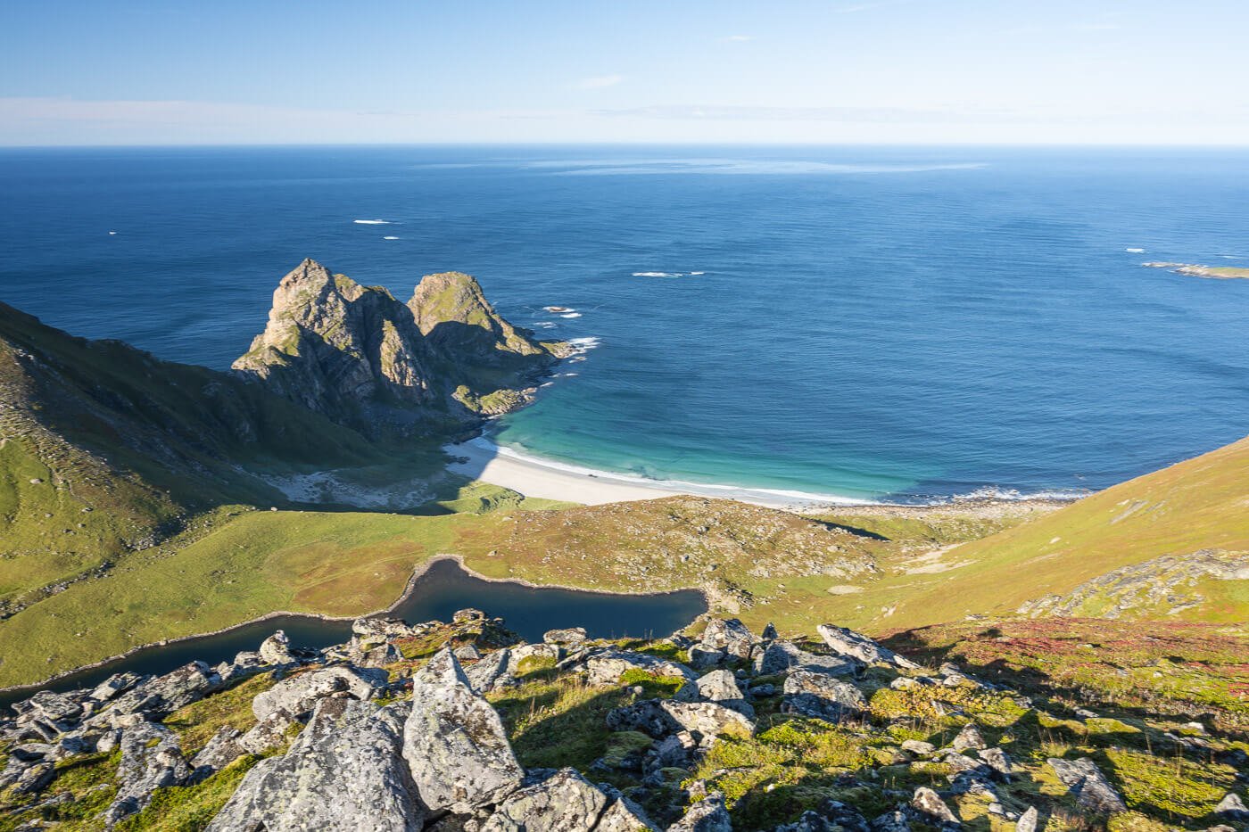
However, my favorite viewpoint was the one above the northern side of the beach. The one you can get to before having to cross the last passage by the sea. It’s this one.
One of the best viewpoints is the one on a dead-end section of the trail.
I’d really love to see this view at sunset, with some nice sidelight and the warm light hitting those rocks. Definitely need to go back sometime in the future for this one.
Video of the Otervika Beach Hike
Here’s also a video I made of this hike. It covers both the sketchy coastal trail as well as the loop that includes Måtind
Where to stay
Bleik offers the most in terms of accommodation close to the trailhead. The most awesome accommodation is the two beautiful huts owned by the Midnattsol camping. that’s a great choice if you are looking for a quiet place. I stayed there once – you have your kitchen and bathroom with a shower. Amazing place as you can just sit outside and watch the northern lights too, during the season. But really, there are a few guesthouses you can choose from in the area.
Otherwise, you can consider accommodations in Andenes, which is just a ten-minute drive away and offers the most facilities, such as groceries, restaurants, etc.
Campsites: the Midnattsol campsite, again, and the camping in Stave The Midnattsol is mostly unmanned, but there’s a Kitchen and, of course, bathrooms with showers. Also a small sauna and picnic tables. In a van/camper, the process is a bit chaotic. Park your vehicle first in the sport you want to occupy, then go to the paying machines. Otherwise, someone may occupy your spot while you pay at the machines.
Another great camping sport, more quiet and secluded, is the Stave Campsite. It’s farther away from the trailhead but provides a more relaxed experience.
You can also wild camp in the area, within the Allesmanretten rules.
Additional Resources
- Do not miss Måtinden if you are on the Island of Andøya.
- Discover the Best Hikes in Andøya
- Check out more Hikes in Norway, with Maps!


Leave A Comment