Batöni Waterfall Arena Hike
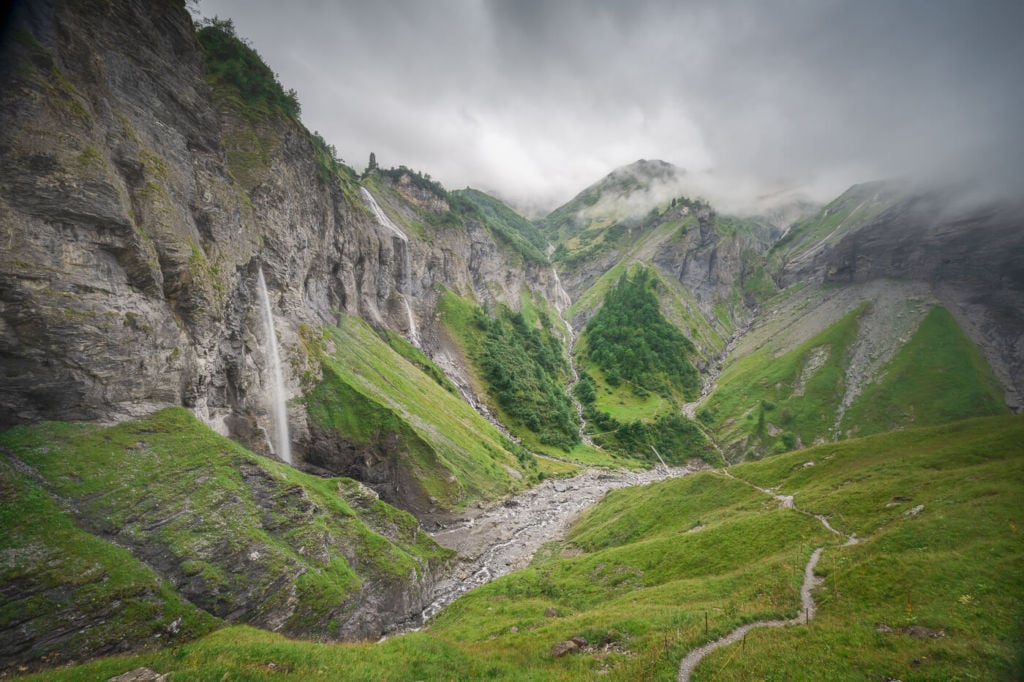
The Batöni Waterfall Arena Hike is part of the UNESCO World Heritage Tectonic Arena Sardona. Located in the Swiss canton of St. Gallen, this is a spectacular location where several waterfalls drop into the same narrow valley.
The Waterfall Arena
Needless to say, it is a very photogenic location, but also a place where you can just sit and enjoy the scenery while you listen to the sound of the flowing water.
The hike starts in the village of Weisstannen, and it’s an enjoyable walk in a narrow valley all the way up to the Waterfall Arena.
How to get to the Batöni Waterfall Arena and Overview of the Hike
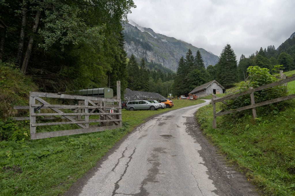
- Getting there and parking: It’s possible to drive up to Weisstannen and park there. There are a few different parking options. The first one will be on your right as you enter the village. You can also continue driving through Weisstannen until you reach a bridge. This is also where the Oberdorf bus stop is. Here you can park by the side of the river. By public transport: you can take the train to Sargans. From the Sargans train station, catch bus Bus 432 to Weisstannen Oberdorf. The bus ride takes about an hour.
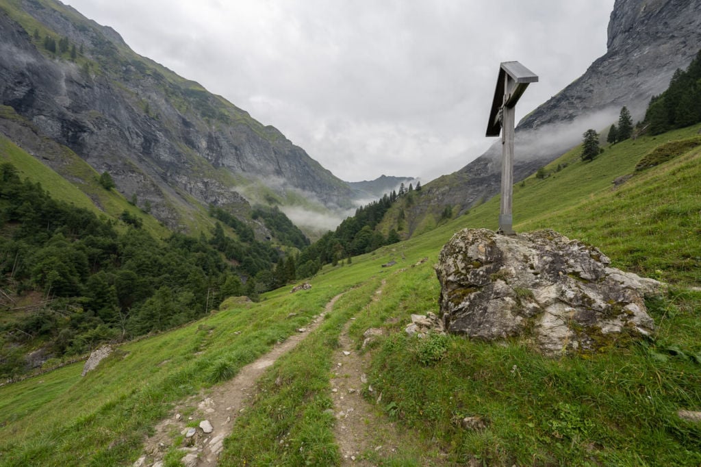
- Start of The Hike: From wherever you parked the car, head towards the Weisstannen Oberdorf Bus stop. Turn left there and keep following the road. You will soon see trail marks pointing toward
- Photography & Scenery value: Mountain scenery with several waterfalls. Don’t forget your tripod and your ND filters :)!
- Difficulty: easy to moderate. Getting to the Batöni Waterfall Arena does not require much effort, but the trail is steep in some places.
- Tip: late spring to early Summer would be the best time to see the waterfalls at their top in terms of water volume.
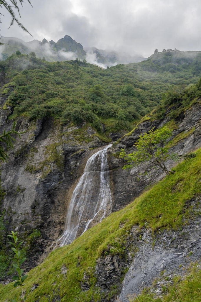
This is where the trail starts
The Batöni Waterfall Arena Trail
The trail I am describing here is a bit longer than what it takes to get to the Waterfall Arena. This is because I included an additional stop on a viewpoint higher up the mountain.
Without the detour, the hike would be 8/9 Km long and take approximately 3:00/3:30 hours. I’ll describe both the original trail and the detour in detail below.
| Distance | Elevation Gain | Hike Time |
|---|---|---|
| 13.5 KM | 990m | 5:00/5.30 h |
“Classic” Batöni Waterfall Arena Hike
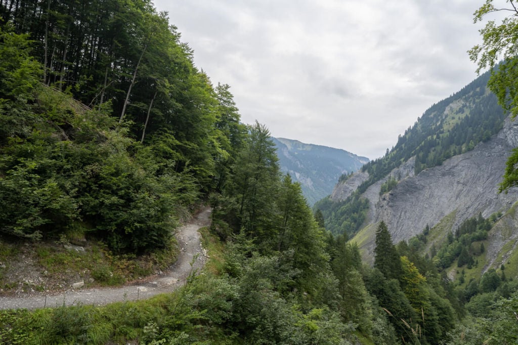
From the Weistannen Oberdorf Bus stop, follow the trail marks for Batöni. The road is paved at the beginning, but the hike is mainly on a dirt, gravel road, which is quite steep in places. Be careful if it’s wet, as it can also be quite slippery.
Gravel Section of the trail
Keep following it but keep an eye out for possible deviations from the original trail. At the time of writing (August 2022), the original trail is still closed due to a landslide. It actually looked like the original trail has been closed for a while already, so perhaps the new deviation is now the new official trail.
One of the proper trail sections.
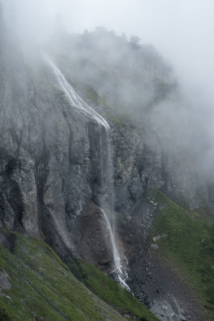
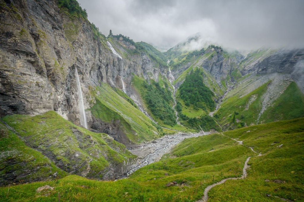
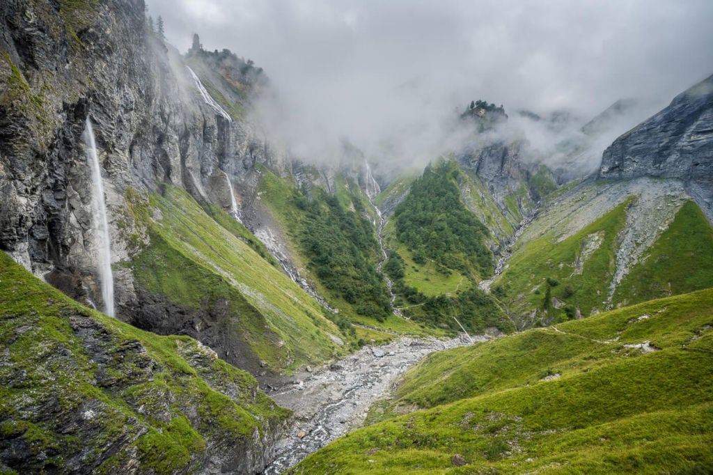
As you keep going up, you will reach an area where the trail forks in two, and you’ll see a few waterfalls around you. A trail will head up the mountain to your left, and to your right, there will be a suspension bridge. This would be the Batöni Waterfall Arena. You have reached your destination.
It may not be immediately apparent that this is the destination, especially if you expect to see something like the classic view with all the waterfalls in a circle. You would have to hike a little further up the mountain on your left to get to that viewpoint. That’s where you would get the best views of the Waterfall Arena.
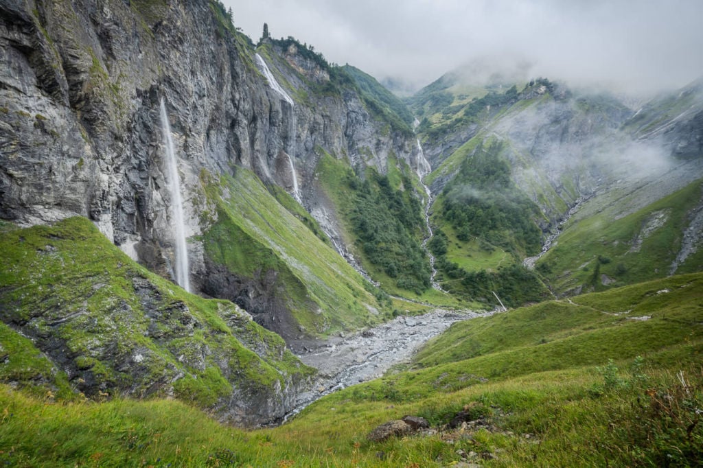
This is where the “classic” 8-9km hike ends.
Batöni Waterfall Arena Hike with detour
I also explored the area on the other side of the mountain, taking the trail on the right at the fork and crossing the suspension bridge.
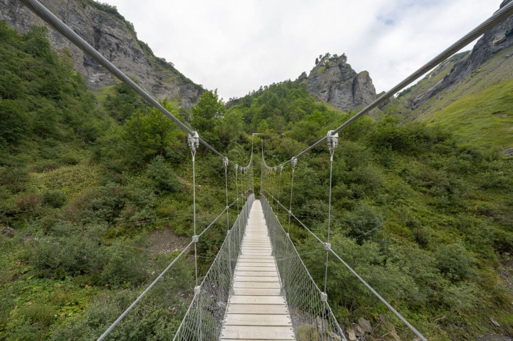
The suspension bridge. It can be slightly wobbly.
The lookout is already visible from the bottom of the valley, as it is a small peak with a few trees on top of it. To get there, you would have first to cross the suspension bridge.
Once you cross the bridge, the trail will start winding its way up the side of the mountain. At one point, the trail will fork in two again. Take the trail on your right and keep following it. Shortly after, the trail will abruptly end near a grass field. You will see a stone wall on your right, and you can follow it until you reach the farther corner of the wall.
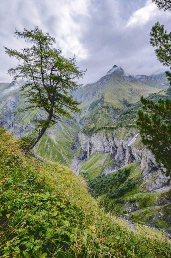
Here you wield be required to step over the small wet and onto a wooded area where in between the trees, you will have some great views of the valley and waterfalls down below. Be careful as this viewpoint is quite exposed, and there is a lot of vegetation, so it’s not easy to see where you are setting your foot.
This detour adds a total of 3-4km to the hike.
Photos and Photography Tips for the Batöni Waterfall Arena Hike
Apart from the classic composition with all the waterfalls lined up, I’ve had the most fun trying to find different vantage points on the other side of the mountain. This is the detour I mentioned above. From up there, the views also open up a lot compared to the views in the valley down below, so you also get great views of the surrounding mountains and landscape.

On the other hand, shooting the waterfalls from there it’s a bit of a challenge as there are a lot of trees and vegetation blocking the views along the trail. That’s also where the fun is to me, though.

The best photos I got from there are in portrait orientation. Personally, portrait mode worked best here as the view from in between the trees are narrow and provide good framing opportunities for increased depth.
If you plan on sticking to the main location, there are three or four different vantage points there too. Obviously, the composition of any of them will be similar, and you can keep exploring the area until you find the one you are the happiest with. They are all very close, so you can move between them quickly.
This is a protected area, and flying drones is prohibited.
Map of the Batöni Waterfall Arena Hike
Where to Stay
The village of Weisstannen offers several accommodations, primarily small, family-run hotels. Staying here is a good option if you want to explore the surroundings further, as there are several trails. On the other hand, the Batöni Waterfall Arena Hike can be easily done in half a day, so you could easily include it as a half-day stop in your itinerary.
Additional resources
- Here’s the official website of the Batöni Waterfall Arena on the Unesco World Heritage Site Tectonic arena Sardona.
- More information on the village of Weistannen here
- Check out my main Switzerland page for more info and PhotoHikes in Switzerland.


What country is this waterfall area in? I’m assuming it’s continental europe but your extremely long winded report made no mention of country. Why should I resort to an internet search?
Hi Ian,
Thanks for pointing that out, I will update the post accordingly.
This is Switzerland, Canton of St.Gallen.
Ian
Because it’s soooooooo difficult to drop “Batöni Waterfall” or “Weisstannen” into a Google map search, right ?
Hi Marco,
This guide is really helpful, thank you!
I’m looking to travel to Switzerland the beginning of September to visit places like lauterbrunnen, grindelwald etc, and have seen this trial also.
I have zero trial/hiking experience, will this be easy to do?
Also I am a female going by myself, will this trial be safe/busy the beginning of September, there will be plenty of people doing it?
Any help would be much appreciated!
Thank you!
Hi Jenny,
Yes, this is a popular trail. Generally speaking, Switzerland is a safe country to hike solo. I pass by women hiking or trail running solo almost every time I’m out. September is a great month to visit, too.
It is quite an easy trail, but I’d recommend stopping at the Waterfall arena (around the suspension bridge), because the other viewpoint I described in the post (above the Waterfall Arena has some moderately exposed sections.
If you stop at the waterfall arena, it’s about 4.5km or 2.7 miles each way, with about 600m/2,000feet of total elevation gain.
Hope this helps – have fun planning (and “executing”) your trip!