Stakkholtsgjá Canyon Hike: a Canyon with a Hidden Waterfall in Þórsmörk, Iceland
The hike into the Stakkholtsgjá Canyon is one of the most popular in the area around Þórsmörk. Stakkholtsgjá is a beautiful, pristine canyon, 2 KM long, with its 100m tall walls covered in green moss and grass. Apart from its beauty, the Stakkholtsgjá Canyon is also well known for its unique highlight of a narrow cave where a waterfall falls into. It’s quintessentially Icelandic, with green, mossy walls and black volcanic sand on the riverbed.
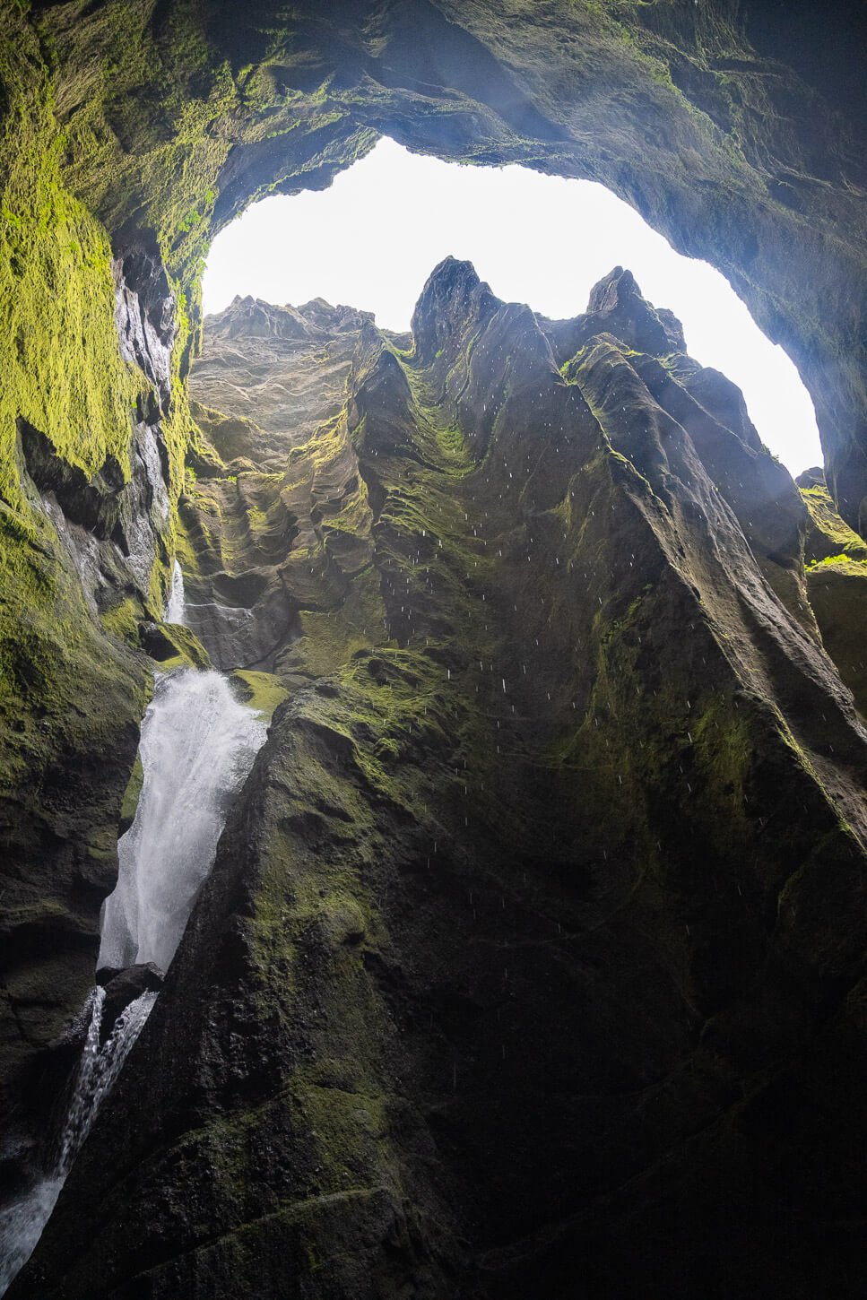
Stakkholtsgjá Canyon Waterfall.
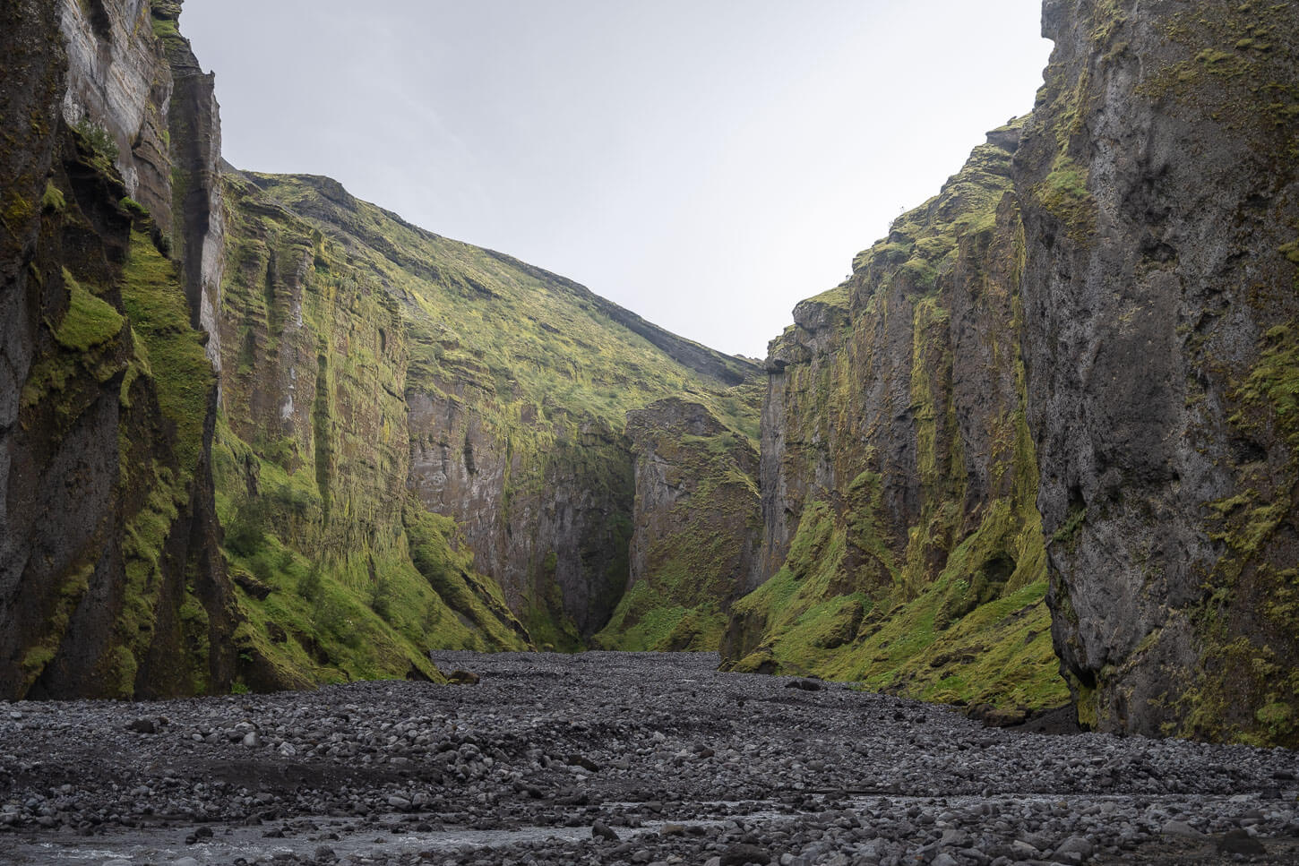
The Stakkholtsgjá Canyon.
This is also an easy, relatively short hike. There’s virtually no elevation gain involved; it is quite short, and you can access it without needing to cross the infamous Krossá River. Still, you’ll need a car approved to drive on Road F-249 (check with your rental company), and there are a few river crossings, including a potentially dangerous one, such as the Steinholtsá river.
So, while the hike is easy, getting there does require some planning. The right vehicle, and quite a bit of time, because the drive requires quite a long detour from the ring road.
Table of Contents
Overview of the Stakkholtsgjá Canyon Hike & Map
The hike into the Stakkholtsgjá Canyon is quite easy, although you have to cross the Stakkholtsgjá river a few times, which in most cases it should be possible without getting your feet wet.
When I visited, I just barely managed it with above-the-ankle boots. There are also some sort of stone dams/bridges you can step on to cross those creeks, so look around for them before attempting to cross the waters.
| Max Altitude | 248m |
|---|---|
| Distance | 4.22 KM |
| Elevation gain | 120m ↑ / 120m ↓ |
| Hike time | 00:45/ 01:15 Hours |
| Hike Difficulty | Easy |
Here is the map of the hike. You can download the GXP file for free from the activity linked below. Do note that this trail includes a couple of detours into side-branches of the canyon.
"Ready to explore more? Discover my curated list of the 17 most spectacular canyons in Iceland. With free GPX Files!"
DISCOVER THE BEST CANYONS IN ICELAND →
How to get to the Stakkholtsgjá Canyon trailhead and Parking
First off, reaching the Stakkholtsgjá Canyon trailhead requires an appropriate vehicle. This means a vehicle not only approved for f-roads, but also specifically for Road f-249, Þórsmerkurvegur. This is because many rental companies specifically prohibit vehicles from being driven on that road. The reason is that there are a couple of treacherous rivers to cross on that road. And, keep in mind, car rental insurance usually does not cover damage to either the undercarriage or damage resulting from river crossings.
The most challenging river crossing on the way to the Stakkholtsgjá Canyon is the last one, the Steinholtsá river. It can swell to a considerable size, and the river bed is rocky. Make sure you familiarize yourself with river crossing techniques before attempting to cross this river, and don’t be afraid to turn back if needed!
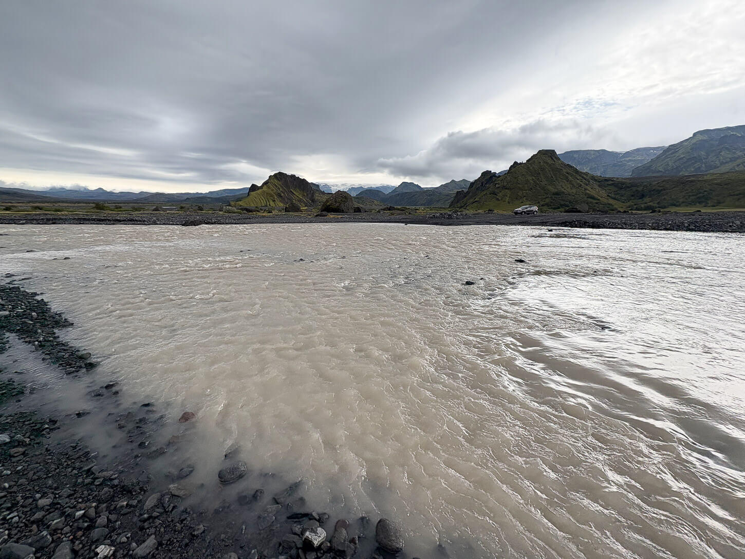
Steinholtsá River.
Also, I’d recommend doing it in the morning, because the last river you’ll need to cross is a glacial river, which is usually higher in the afternoon.
- Driving Directions: from the ring road, you’d first need to follow the road signs to Seljalandfoss, and instead of turning into the parking area, keep driving straight on road 249, until it turns into a gravel road first, and then into road f-249. There are several river crossings along the way, each one bigger than the previous one.
- Parking: There is a somewhat large parking area by the trailhead, located at the entrance of the canyon. There are also a couple of wooden tables with benches, so you can’t miss it.
- Public Transport: none. You would need to take a private tour to the Stakkholtsgjá Canyon.

Stakkholtsgjá Canyon Parking and Trailhead.
The Stakkholtsgjá Canyon Hiking Trail
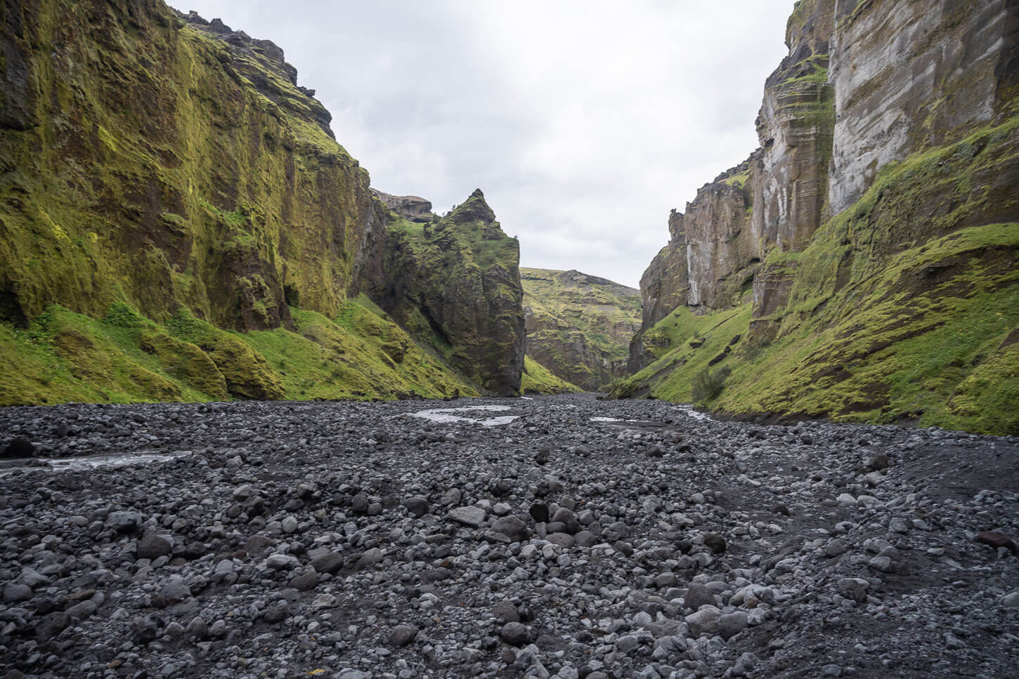
From the rocky parking area at the entrance, you can head in the general direction of the Canyon. There is no visible trail for most of the hike, as too are essentially walking on a very rocky riverbed.
The only hints of a trail, here and there, are where the rocks mix with the soil, mostly made of black sand, where you can see footprints of other hikers. Or, if you pay close attention, you should be able to spot “flatter” areas on the rocky terrain. That’s where people walk. It takes a bit to get used to seeing that, but you’d get the hang of it after a while.

Entering the Stakkholtsgjá Canyon

If you want to go directly into the cave with the waterfall, it’s at the far end of the Stakkholtsgjá Canyon. It is not really visible from the outside, and you can see the entrance only when you are close to it.
Also, there are a couple of smaller “ramifications” inside the canyon. Those are explorable too, but you may need to cross the river a few more times. I explored both of them without venturing too deeply into them, as I did not have much time. Heavy rain was forecast to start within half an hour, and I wanted to leave before that, because of the river crossings. But anyway, both of these ramifications offer quite some good views, so I think it’s worth taking those short detours if you have the time.

The Canyon has a couple of smaller branches worth exploring.
The Waterfall is at the far end of the main Canyon
Back to the cave, you can only enter it through a passage between the walls of the canyon. It isn’t too narrow at the beginning, and you can’t see the waterfall either, but as you progress following the river upstream, you will reach the bottom of the waterfall, where the cave opens up to the sky. This passage isn’t too narrow or claustrophobic, and a few people can be in the cave at any given time. It’s quite “rainy” in there too, though:)

Looking back at the entrance of the waterfall cave

The lower part of the waterfall inside the canyon
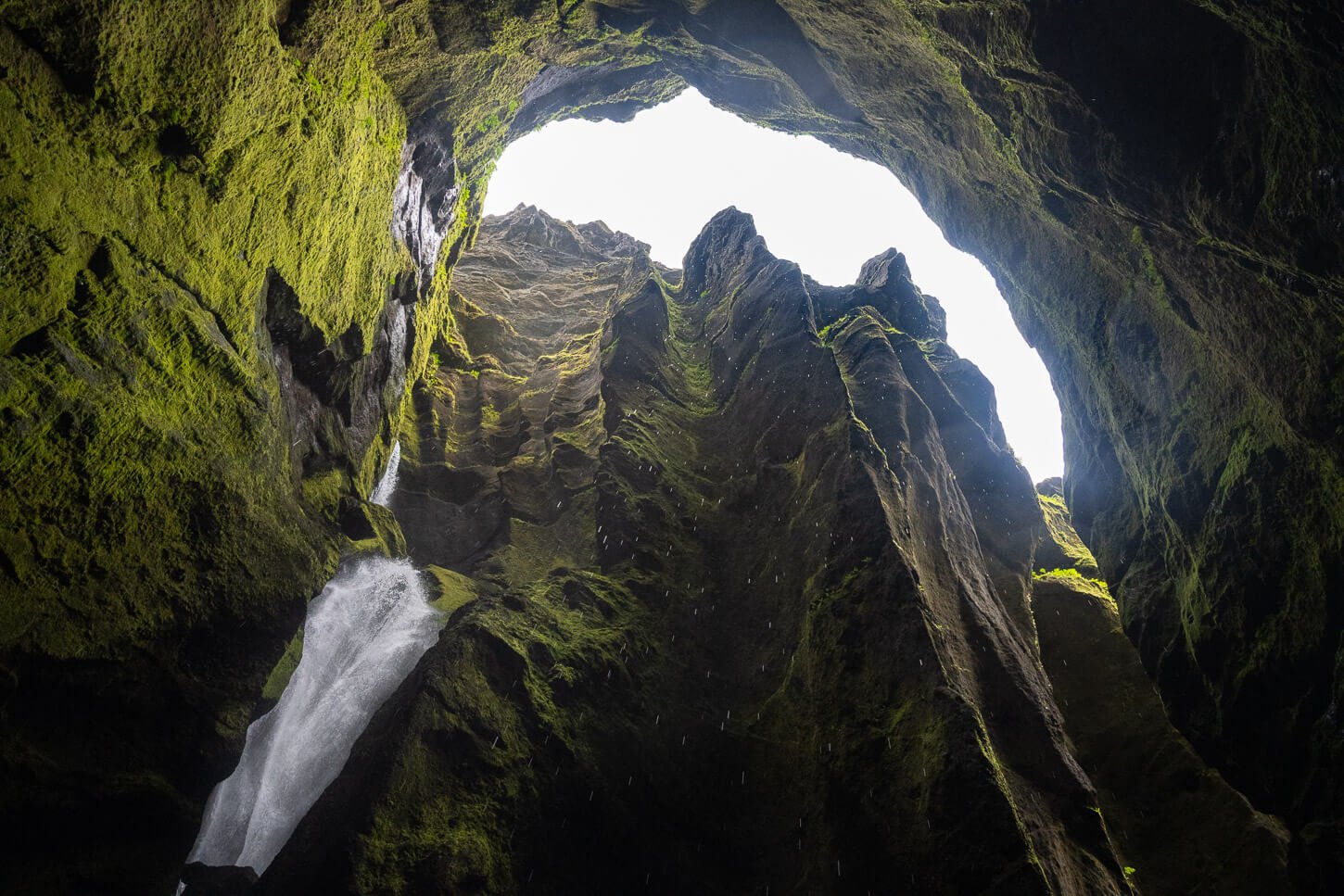
The upper part of the same waterfall
Stakkholtsgjá Canyon Photos and Photography Tips
The Canyon, even without the cave, is a beautiful location to photograph in its own right. It’s great for moody/atmospheric work, so it’s great to visit on cloudy or overcast days. On such days, the soft light that comes through the clouds helps to enhance the features and details of the canyon carved into the volcanic rocks.

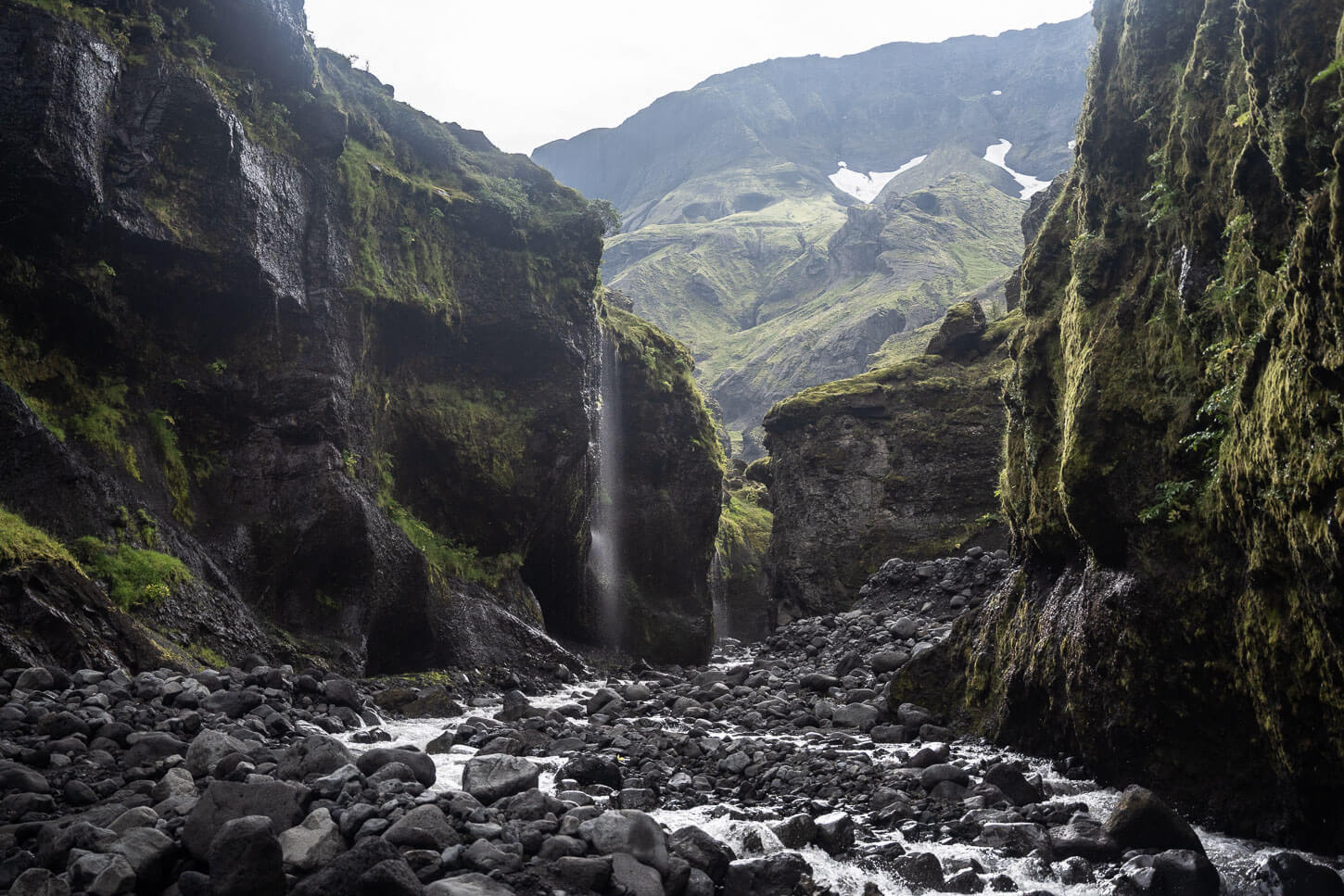
The Stakkholtsgjá Canyon.
For the most part a lens between 18-70mm full frame will be enough. All the photos here are taken with a 24-70mm lens too.
One mistake I made was not to bring my 14-24mm lens. When you enter the cave with the waterfall at the end of the Stakkholtsgjá Canyon, you will want to have a wide and fast lens. It’s narrow, dark, and it basically rains too in there, as the rocks constantly drip water. With a wide and fast lens, you’d get a better view of the whole cave and keep the gear less wet.
Unfortunately, I forgot it in the car, as I was a bit in a hurry. The weather forecast was showing heavy rain at any moment, and with an already swollen river to cross, I surely didn’t want to be caught there.

Where to stay
Be careful when looking for accommodations in the area, as sometimes Volcano Huts comes up as a suggestion, but you can only get there by crossing the Krossá river, which is an extremely dangerous river to cross, and that should be avoided in a rental car.
There are a few guesthouses near the southern part of road 249 however most the accommodations in the area are around the town of Hvolsvöllur. Though not fancy, it’s quite a good town to stay for a nigh or two as a base to explore trails in the area.
Additional Resources
- Additional stops you shouldn’t miss on the way to the Stakkholtsgjá Canyon: Nauthúsagil and Nauthúsafoss, and Stigafoss, another beautiful, hidden waterfall.
- Discover more Hikes in Iceland here.


Leave A Comment