The Sigöldugljúfur Canyon, The Valley of Tears
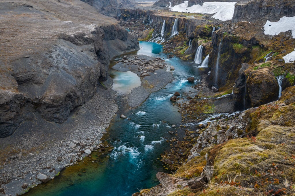
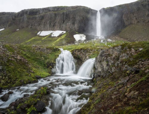
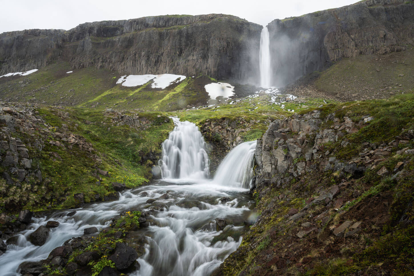
The Sigöldugljúfur Canyon, also known as the Valley of Tears, is a Canyon surrounded by a fantastic series of waterfalls, called Lekafossar, seemingly stemming out of nowhere. This is because the water runs underground below a layer of solidified lava and drops straight into the canyon below.
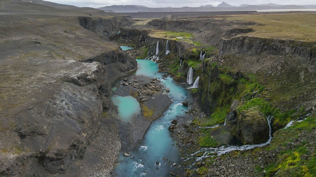
A bit of a fun fact: This canyon exists because of the dammed Krókslón reservoir. Water from the reservoir permeates the layers of lava in the area. The water then re-emerges from the Canyon walls. Hence, without the Dam, the canyon will mostly be filled with water, and the waterfalls would be completely submerged, too.
If you are heading to Landmannalaugar, this is a great stop to include in your itinerary. It is accessible with 2WD car too. Even if the road is rough, The hike is less than two km long, so it would take most people about half an hour/45 minutes.
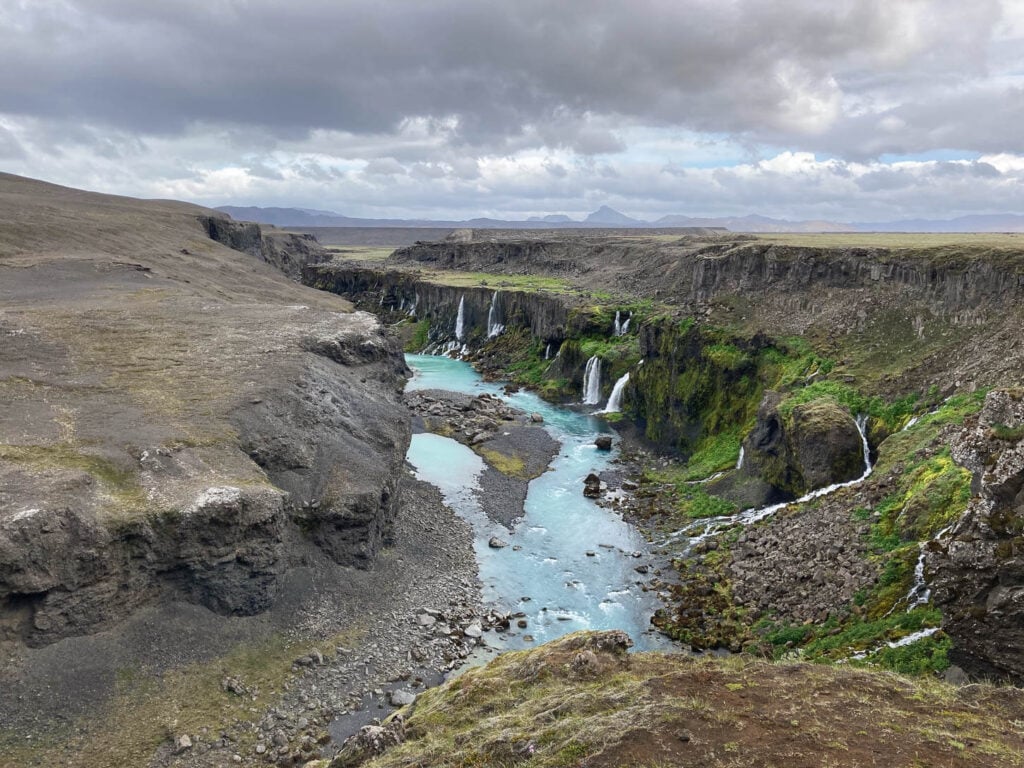
Lekafossar Waterfalls in the Sigöldugljúfur Canyon.
Going to Iceland? Get a Car Rental Discount!
As a reader of The Photo Hikes, you get a 5% discount on your car rental when booking with Blue Car Rental through this website. The discount will be automatically applied to the booking through the following link
Table of Contents
Overview of the Hike to the Sigöldugljúfur Canyon
The hike to the Sigöldugljúfur Canyon is more of a walk than a proper hike. At just over a mile long and on mostly flat terrain, it is suitable for all skills level. Beware, it may be slippery or muddy in places if it recently rained.
The best time to visit Sigöldugljúfur is Summer to early Autumn. I visited as early as mid-may. I had to leave the car by the power plat and continue on foot as the road was still closed due to the spring thaw.
If you’d like to discover more similar waterfalls, you may also want to check out my eBook “Iceland – the Best Waterfall Hikes and Walks“; with 103 hikes or walks and a total of 172 waterfalls, 32 GPX files, it is one of the most complete and exhaustive resources available on the topic. Good for planning your itinerary as well as discovering new waterfalls while on the road.
| Max Altitude | 535 m (1,755 ft.) |
|---|---|
| Distance | 1,86 KM (1.15 miles) |
| Elevation gain | 50 m ↑ / 50 m ↓ (164 ft.) |
| Hike time | 00:30/00:45 Hours |
| Hike Difficulty | Easy |
Here’s the map of this hike. You can download the GPS file from the Komoot activity. You could use it to get to the trailhead, should you need to.
"Ready to explore more? Discover my curated list of the 17 most spectacular canyons in Iceland. With free GPX Files!"
DISCOVER THE BEST CANYONS IN ICELAND →
How to Get to the Sigöldugljúfur Canyon and Parking
Technically, the drive to the Sigöldugljúfur Canyon does not require an F-road car. The trailhead is located along Fjallabaksleið nyrðri, or road f208 north, which is no longer an F-road. So do you need a 4X4 or AWD car to get to Sigöldugljúfur? Technically, no. You could drive a 2wd car up to the parking area and leave the car there.
However, a couple of things should be considered. First of all, check with your rental company if you are allowed to drive three. Secondly, the road is still very rough. Rental insurance usually does not cover damage to the undercarriage, and usually does not cover damage caused by gravel to the bodywork or the glass parts either. So make sure you have adequate insurance to be on the safe side.
- Driving Directions: If you are coming from Reykjavik, you would have to drive to Road F26 and keep following it past the Hrauneyjar highland centre. From there, keep following the signs to Landmannalaugar. You will drive past a Hydroelectric power plant where the road turns rough. It’s only about a five-minute drive to the parking from here.
- Parking: When you cross the first big hill on Fjallabaksleið nyrðri, you will see a wide parking area to your right. Leave the car there.
- Public Transport: No public transportation option exists unless you join a group or private tour.

Sigöldugljúfur Parking Area.
The Sigöldugljúfur Canyon Trail
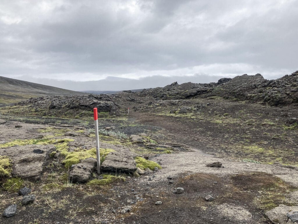
In 2024 a proper trail has been marked all the way from the parking area to the Canyon. So it is even easier to find it now, as the trail has been fully signposted with red trailmarks.
From the parking area, you would need to cross the dirt road to access the trail. This part traverses an old lave filed, which is also nice in itself, with all the different shapes the ancient, solidified lava can take.

Sigöldugljúfur canyon trailhead sign.
The trail -s well-marked and easy to follow.
Keep following the trail downhill through the lava field. The Canyon is not immediately visible, it will reveal itself once you’re almost on top of it. The main viewpoint will also be clearly recognizable as a clear, flat area on the edge of the canyon.
It’s possible to walk around the canyon’s edge, but be careful not to get too close as the rock may be friable in some places.

It’s also possible to walk further toward the lake following a dirt service road from the Power Plant. Although there are no better views of the waterfalls from further up the road. it’s aon out and back trail, so you’d need to take the same trail to get back to the parking area.
The Sigöldugljúfur Canyon Photos and Photography Tips
This is a stunning location, no doubt. Photographically speaking, the canyon itself is very photogenic. However, there are a couple of limitations that will require some additional creativity or luck to get the best out of this location.
- Background: There isn’t much of an interesting background to the Canyon and the Waterfalls. Sure, the Canyon is beautiful, but there is nothing behind it to complement the view. To overcome this, you could wait for some interesting clouds or light to fill the frame.
- Composition: here as well, there is little to choose from. There are a few good spots along the rim of the canyon, with good foreground, but the composition will be essentially the same apart from that. A drone may help with that, however.
A good solution may be visiting in the weeks around the Summer Solstice. During that time, sunsets are very long in Iceland because of its latitude. Hence, this may give you more chances of catching a good sunset or Sunrise.
In terms of lenses, you will need a wide lens, but not an ultra-wide, or the Canyon and the Waterfalls will look too small. A lens 18mm and above will be good enough; ideally, I’d recommend 24mm for most cases and compositions.
Lastly, you can fly a drone here – assuming you comply with any other local regulations. Check my post on Flying drones in Iceland for more info.

Drone Photo

Another Drone Shot, with human figure for scale
24mm photo of the waterfalls in the Canyon

A top-down aerial view of the Canyon.
Video of the Sigöldugljúfur Canyon
Here’s a short drone video from this location:
Where to stay
This location is in limbo between the Highlands and the country’s southern region. So the options are either camping or Huts in the highlands, or the only accommodation available is the Highland Centre Hrauneyar on Road 26.
Additional Resources
- More awesome waterfall hikes in Iceland? Check these out: Háifoss, Hengifoss, Rauðfoss, Hraunfossar, or the Ófærufoss Hikes
- If you like this location, you may also like these other beautiful hikes: the Fjaðrárgljúfur Canyon and the Múlagljúfur Canyon or Kolugljúfur.
- Check out more Photo Hikes in Iceland here.


Leave A Comment