The Hengifoss Hike, East Iceland
Hengifoss is one of the most beautiful waterfalls in Iceland, and while there’s a bit of a hike to get there, it’s absolutely worth it. It is also the third-tallest waterfall in Iceland, with the first being Morsáfoss (or Morsáfossar, plural) and the second Glymur.
Apart from that it’s probably the most unique of the three.
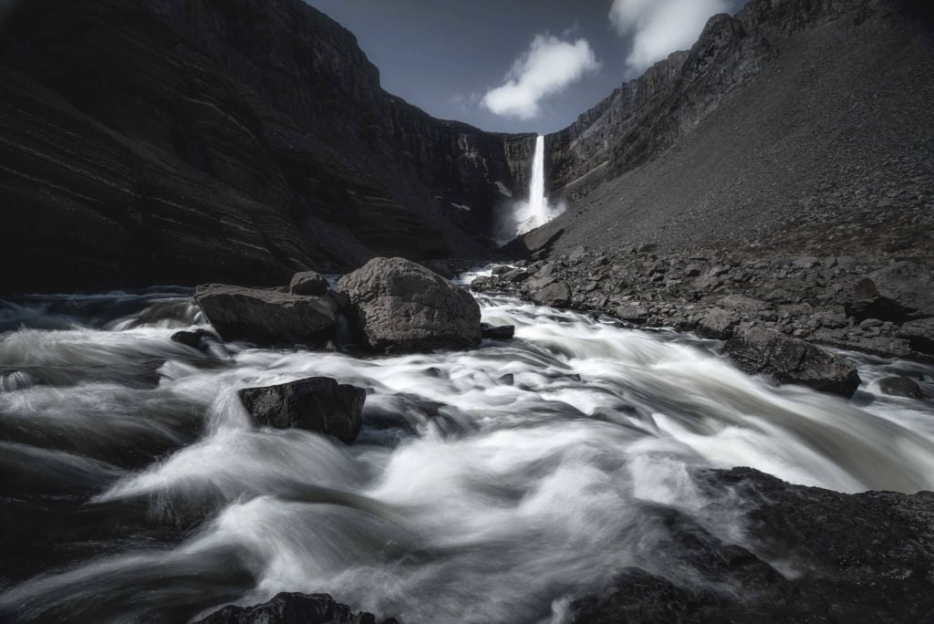
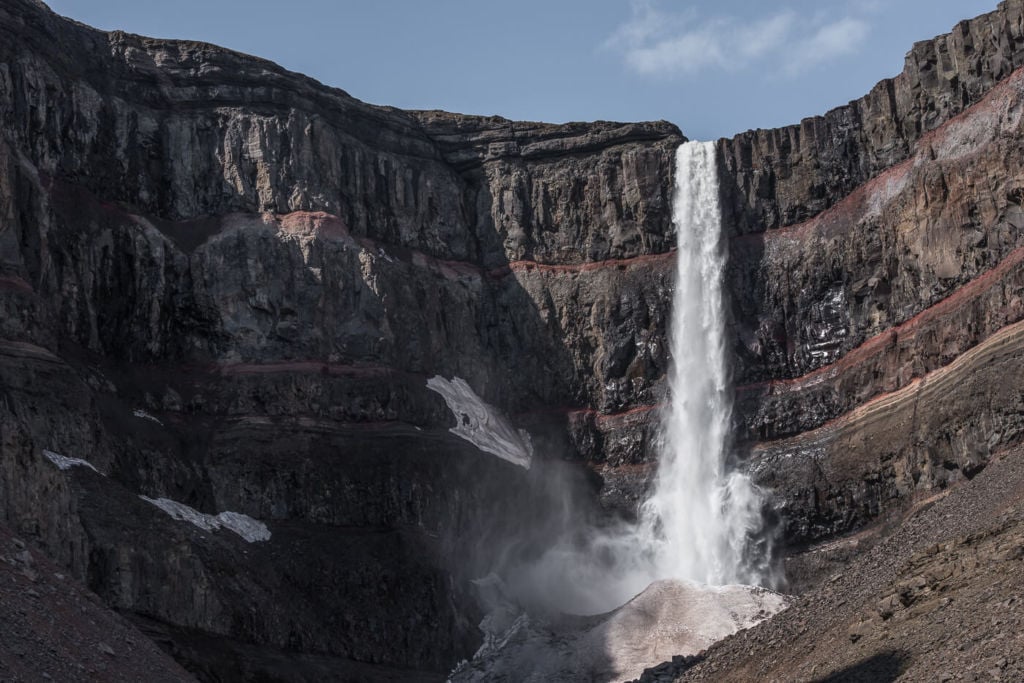
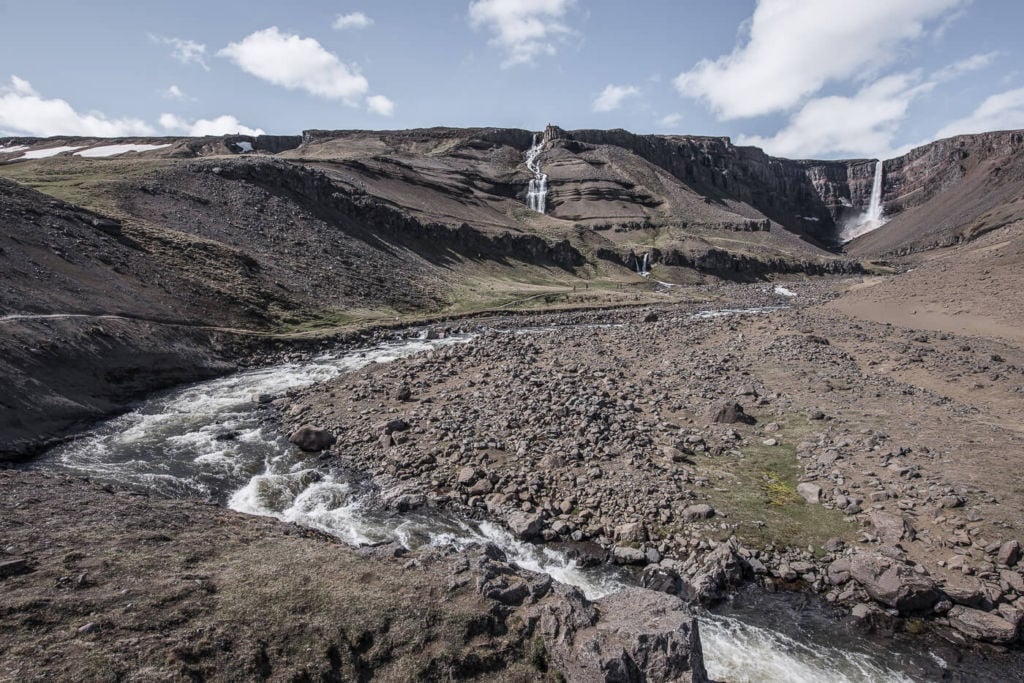
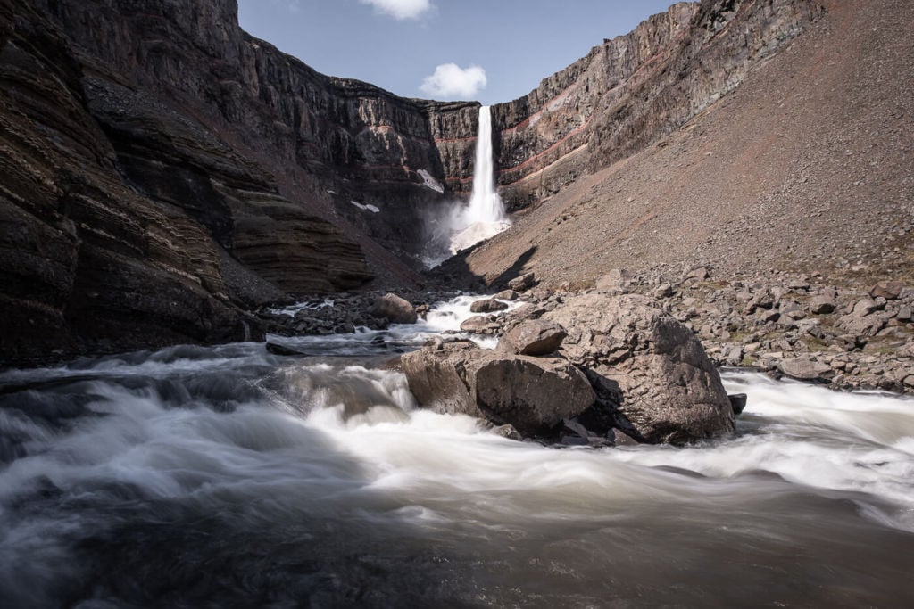
The cliffs Hengifoss drops from are spectacular in their own right. On top of that, the red clay and basaltic strata add a unique visual effect to the scene. It’s one of those wonders of nature that you could spend hours looking at.
Getting to the trailhead requires a bit of a detour from the Ring Road, but it is definitely worth it. the hike is relatively easy too, at less than 5 KM
How to get to Hengifoss
- Getting there: if you are on the Ring Road (Road 1), you should take road 931 from Egilsstaðir. Keep following the road till you arrive at the Parking area at the start of the trail. If you are coming from the south and want to take a shortcut, you can take road 939 after Djúpivogur. It’s a gravel road suitable for 2wd cars, and the drive is quite scenic. Road 939 will then merge into Road 95. From there, you can continue onto Road 931 until you reach the parking area by the trailhead. This shortcut will save you about an hour on the road, so you could instead spend that time looking at this majestic waterfall :)! If you are looking for car rental options, I can definitely recommend Blue Car Rental (and you get a 5% discount through ThePhotoHikes!)
- Start of The Hike: From the Hengifoss Car Park. You can’t miss the trail from there.
- Photography & Scenery value: scenic hike along the river with multiple waterfalls. Bring your tripod for long exposures!
- Difficulty: Easy to medium, depending on fitness. The elevation gain is not much, less than 300m. The trail does not present any particular challenges, such as exposed or steep areas.
- Tip: Another little-known but fascinating hike nearby is the so-called “Waterfall Circle Hike“. It is an amazing hike full of stunning waterfalls. So if you are looking for more hikes in this area, you should definitely consider including the waterfall circle in your itinerary.
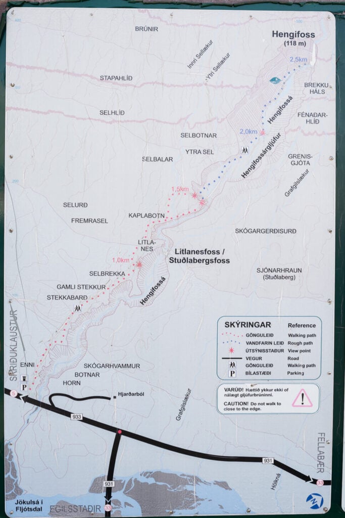
Info board with overview of the trail.
Overview of the Hengifoss Hiking Trail & Map
The hike is relatively easy, on well maintained trails for the most part, at least for the first half. In the second part, where the trail enters starts to enter the canyon and approaches the riverbed, as you can see in the info board above.
If you’d like to discover more similar waterfalls, you may also want to check out my eBook “Iceland – the Best Waterfall Hikes and Walks“; with 103 hikes or walks and a total of 172 waterfalls, 32 GPX files, it is one of the most complete and exhaustive resources available on the topic. Good for planning your itinerary as well as discovering new waterfalls while on the road.
| Distance | Ascent | Duration |
|---|---|---|
| 4.71 Km | 230m | 1.3/2 Hrs |
Here is the GPS track of this hike. You can download it for free from the activity linked below, though it’s not really needed to visit Hengifoss since the trail is well signposted.
Hike to Litlanesfoss and Hengifoss
The trailhead is immediately visible from the parking area, but you you can already see the upper part of the waterfall. there’s also a bridge where you can get a good view of the upper part of the ravine where the river from the waterfall flows into.
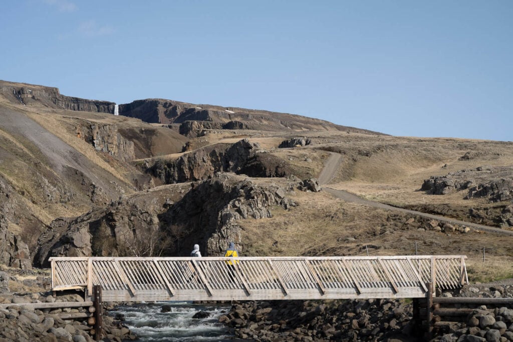
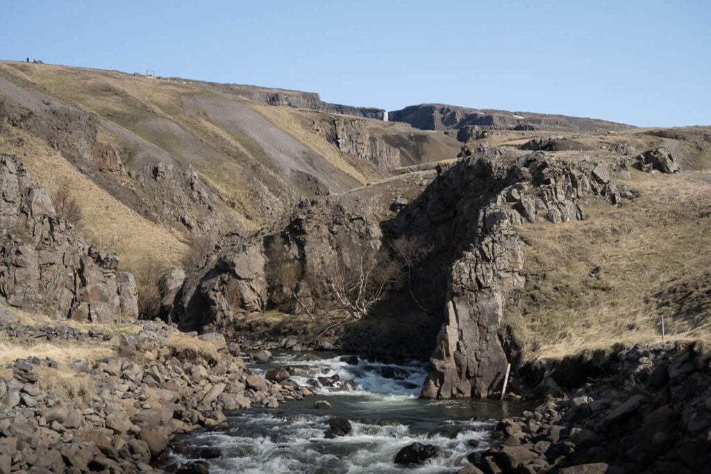
However the “hikeable” trail is only on the left had side, so from the bridge you, need to start heading up the hill. The first part is relatively steep, it’s where most of the elevation gain. Despite that, it’s quite an easy walk as the trail is well maintained.
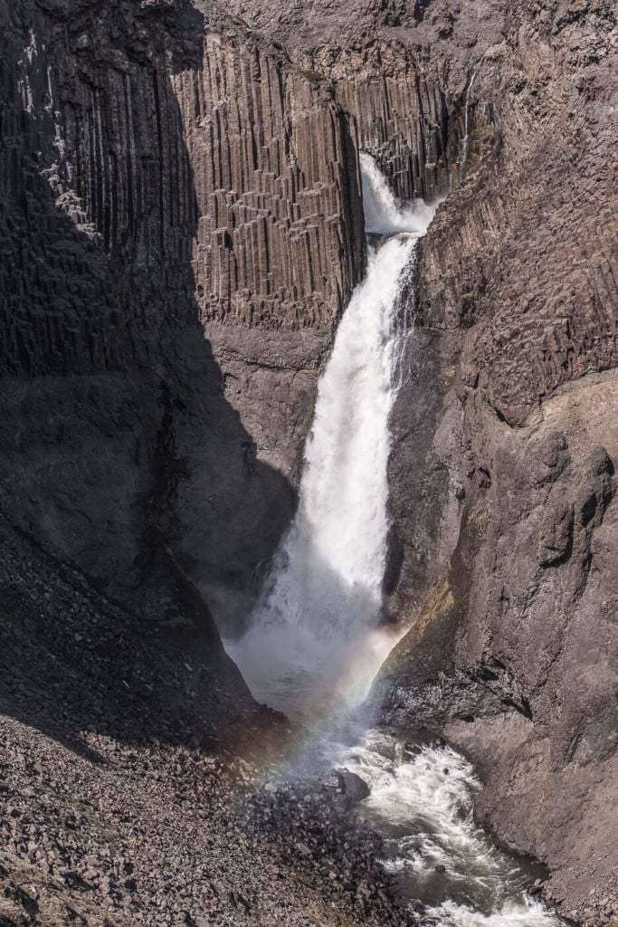
After about 1 KM into the hike you will come across another beautiful waterfall surrounded by basalt column, Litlanesfoss. While the viewpoints are somewaht limited, the view of the waterfall is pretty good.
From here the trail continues on a well maintained path for another 500m or so, where you reach the first viewpoint of the waterfall – which is still quite far. From there, the trail continues to follow the river upstream for another 2km or so until the end point of the trail where, in recent years, a viewing platform has been installed.
Hengifoss Photos and Photography Tips
First of all, Litlanesfoss, the first waterfall on this trail. Litlanesfoss actually is a beautiful waterfall in its own right. Nestled deep is in a little gorge and surrounded by basalt columns, it’s a very niche waterfall to photograph in itself.
However, there are not many compositional choices for this waterfall as it sits in a gorge below the trail, so the only vantage points are the ones you can get to on the side of the trail.
Litlanesfoss surrounded by basaltic columns.

Litlanesfoss, with Hengifoss in the background.
As you hike past Litlanesfoss, you will gradually see more and more of Hengifoss until you’ll be able to see it in its entirety. There are quite a few good views from this part of the trails too, which are worth a photo stop. Once you reach the waterfall, compositional choices are somewhat limited, though. Apart from the viewing platform, the waterfall is deep in the gorge, so the vantage points are naturally limited.
The waterfall faces the South-east, so it gets the best light in the middle of the day, while later in the afternoon it will be in the shadows. That is, assuming the sun is out of course, which in Iceland isn’t a given.

Photo desaturated in post-processing, with some added vignetting.
When I visited in 2016, there was no viewing platform yet, so you could get as close to the platform as the river allowed. However, a platform was recently built, and getting that close to the waterfall is no longer possible. So, if you visit, please respect the area and do not walk beyond the viewing platform.
Where to Stay
Not much in the immediate vicinity of the waterfall, but there are several hotels and camping accommodations around Lagarfljót. The hike to Hengifoss is also easily done in half a day, so you could easily integrate it into your ring road itinerary and continue on to the next attraction, as there’s plenty to see in the area.
Additional resources
- If you are looking for other epic waterfalls, check out the The Múlagljúfur Canyon, Haifoss, Rauðfoss or Ófærufoss Hikes.
- Other hikes nearby that are worth a stop: The Strútsfoss Hike and the Laugarfell Waterfall circle.
- Check out more Photo Hikes in Iceland here.
- Discover the best hiking books and guides on Iceland.
Car or Camper Van Rentals
I can definitely recommend two companies here:
- Cars: Blue Car Rental, which is the largest Car rental company in Iceland, and for good reasons. Free Cancellation, Unlimited mileage, 24-hour break assistance, SCDW, CDW, TP, and GP insurance are included in the price. Blue Car Rental is also located within walking distance of the Keflavik Airport, so you can be on your way to explore Iceland right away. I’ve always been happy with my rentals there, which is why I’m happy to recommend their services here on my blog.
- Camper Vans: CampEasy. With CampEasy, you can rent 2WD or 4×4 campers alike. With a raised Chassis, larger tires, and extra insurance with reduced liability for river crossing, their 4X4 campers are the best choice for your trip into the Highlands. Their Website also provides extensive information about roads you can take and instructions on river crossings. Perfect choice for a hiking holiday in the highlands!
These are my two favorite companies in each respective rental area, which I why I am happy to recommend both here. If you also like this blog, booking through them is a great way to support it. I’ll get a small commission fee at no additional cost, so you can essentially support the running costs of this blog for free too.


Leave A Comment