Stoos-Fronalpstock Snowshoe Hike, Switzerland
The Stoos-Fronalpstock Snowshoe hike is a moderately difficult snowshoe hike that is both challenging and fun. Not to mention the views from the top, which are beyond amazing. Looking at Lake Lucerne from Fronalpstock is a sight to be seen, even more so when the surrounding mountains are painted white by a recent snowfall.

Lake Lucerne, from the top of Fronalpstock.
Additionally, while most of the marked trail is close to other infrastructure on the mountains, the views along the trail are pretty spectacular. While getting to the top is quite physically demanding, you will often stop along the trail to gaze at the landscape, and time will fly.
If you don’t have a pair of snowshoes, no worries. You could also rent them on-site. Also, you can get to the top or back down using the chairlift that serves the Fronalpstock Gipfel restaurant. This is handy if you want to snowshoe your way up or down the mountain.

The village of Stoos on a snowy morning.
Table of Content
Overview of the Stoos-Fronalpstock Snowshoe Hike
| Max Altitude | 1,921 m |
|---|---|
| Distance | 9.03 KM |
| Elevation gain | 710 ↑ / 710 ↓ |
| Hike time | 4:00/5:00 Hours |
| Hike Difficulty | Moderate to Difficult |
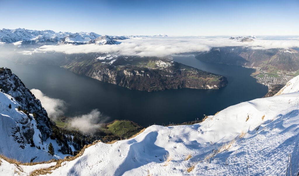
Panoramic Image from the top of Fronalpstock.
How to Get Fronalpstock and Parking
- Driving Directions: to get to Stoos, you can either go to the Morschach Luftseilbahn cable car station or the more modern StoosBahn station in the Muothatal valley. I only use the older Morschach station, which is usually less crowded and quicker to get to from Lucerne. The price is the same for both, 11.00 CHF with the half-fare card. The railway, though, is an attraction in itself.
- Parking: Both locations offer ample, onsite, paid parking areas.
- Public Transport: to get to the Stoos railway station, you can get a train to the station of Schwyz. From there, take bus 501 toward Muotathal and hop off at Schwyz Stoosbahn (Talstation). To get to the Morschach cable car station, take bus 504 from the Brunnen train station to the Morschach Luftseilbahn Station.
Stoos-Fronalpstock Snowshoe Trail and Photos
The snowshoe trail Strats right out of the Mountain station of the Morschach cable or the Stoos railway. The usual pink Snowshoe/Winter Hiking trails will point you in the right direction. The trail is also well marked, with the colour-coded pink poles. It is, therefore, easy to follow. Still, it is easy enough to make short detours if you want to cut the trail or check out other areas close to it.

The pink signs for Fronalpstock are the ones you need to follow.
Initially, the trail will cross the car-free village of Stoos to turn up the mountainside after 5-10 minutes. From here, it is a relatively steep snowshoe hike to the top.
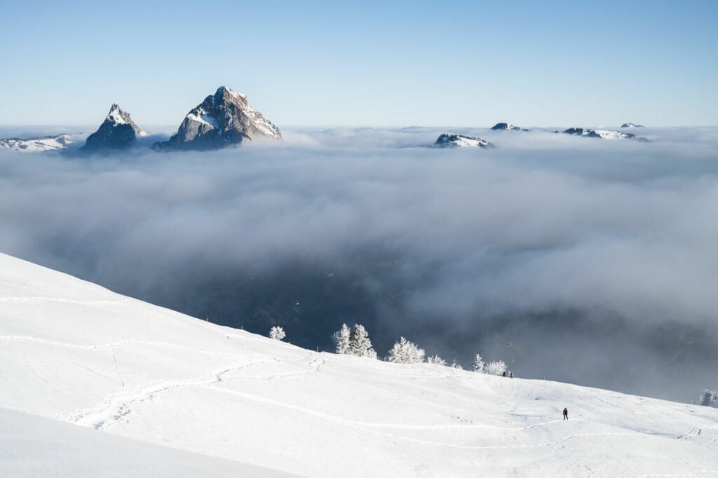
Fear not, though! There will be fantastic views all along the trail, both over the Village of Stoos and the mountains surrounding it, as well as on the other side, where Kleiner and Grosser Mythen dominate the landscape.
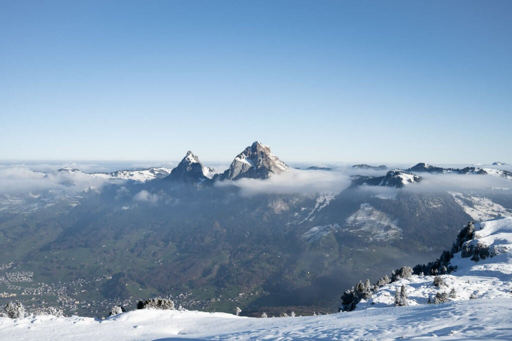
The Kleiner and Grosser Mythen, the two mountains in the background.
I took my time to hike up with my snowshoes. I enjoy being in the magic-white snowy landscape and always take my time on my way up. It took me almost four hours to get to the top, but less than one to get back down!
All in all, this probably is one of the most scenic snowshoe hikes in Central Switzerland.

The magic of winter!

Some more winter magic.

Drone shot of the village of Stoos.

The Kleiner and Grosser Mythen. Drone Shot.
Again, the imposing Kleiner and Grosser Mythen from the snowshoe trail to Fronalpstock.

The Fronalpstock Gipfel Restaurant, on top of Fronalpstock.

Closeup of the Kleiner and Grosser Mythen emerging from the clouds.
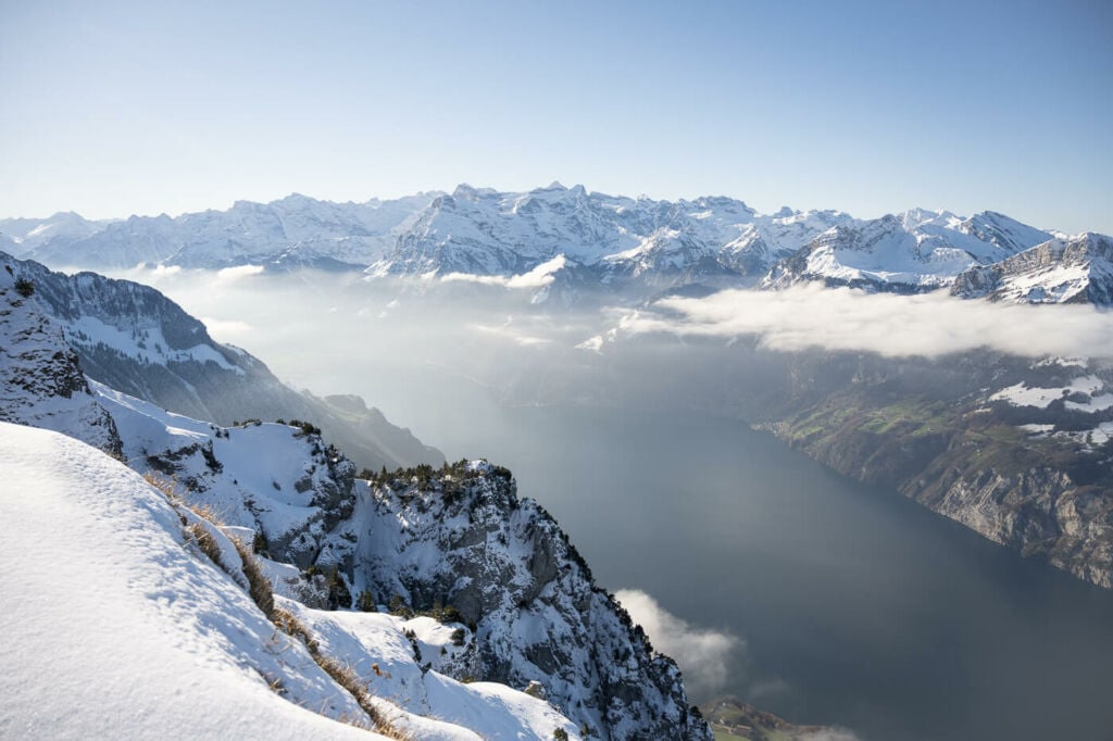
Lake Lucerne.
Lake Lucerne, from the top of Fronalpstock.

Selfie – looking at the landscape from the top of Fronalpstock.
Video of the Hike
I’ve also made a short video of this snowshoe hike. If you want to have a feel for the trail, you can watch it here, or on YouTube:
Map of the Stoos-Fronalpstock Snowshoe Hike
Here is the map of my Snowshoe hike. The trail is easy to follow, but if you want a GPS track, you can download it from the Komoot activity below:
Where to stay
- The Fronalpstock Gipfel Restaurant also serves as a hotel. This makes it possible to spend the night there and enjoy a Sunset or Sunrise from the top of the mountains.
- The Village of Stoos, where the trailhead is, offers several different types of accommodations. Plenty of choices there!
Additional Resources
- More Snowshoe hikes in Switzerland: Englelber Ristis, Sunnig Grat, Arnisee , Melchsee-Frutt – Erzegg or the Obertrübsee Snowshoe Hike in Englelberg.
- This is also a great hike in summer; check it out here.
- On-site rentals
- Check out my main Switzerland page for more info and Photo Hikes in Switzerland.
- Check out my top Snow and winter Landscape Photography Tips


Leave A Comment