Dynkur Waterfall Hike, Highlands, Iceland
Getting to Dynkur definitely is no easy feat; it takes a long drive on a very rough dirt track and a bit of a hike to get to this stunning waterfall along the þjórsá River.
Dynkur is one of the very best waterfalls in Iceland, up there with all the major household names in the Icelandic Waterfalls scene.

Dynkur, Drone Photo
So why isn’t this a well-known waterfall if it is that beautiful? Well, first of all, it is a very remote location and, second of all, it’s a very long drive on a very rough track. Getting there is a bit of an adventure in itself too.
A bit of a fun fact: this waterfall actually has two names. Dynkur, of course, and Búðarhálsfoss. Why? Apparently, people from the East side used to call it Dynkur, while those on the West side called it Búðarhálsfoss. Hence the double name.
So, as you probably guessed already, the trail described in this post is the one approaching the waterfall from the East.

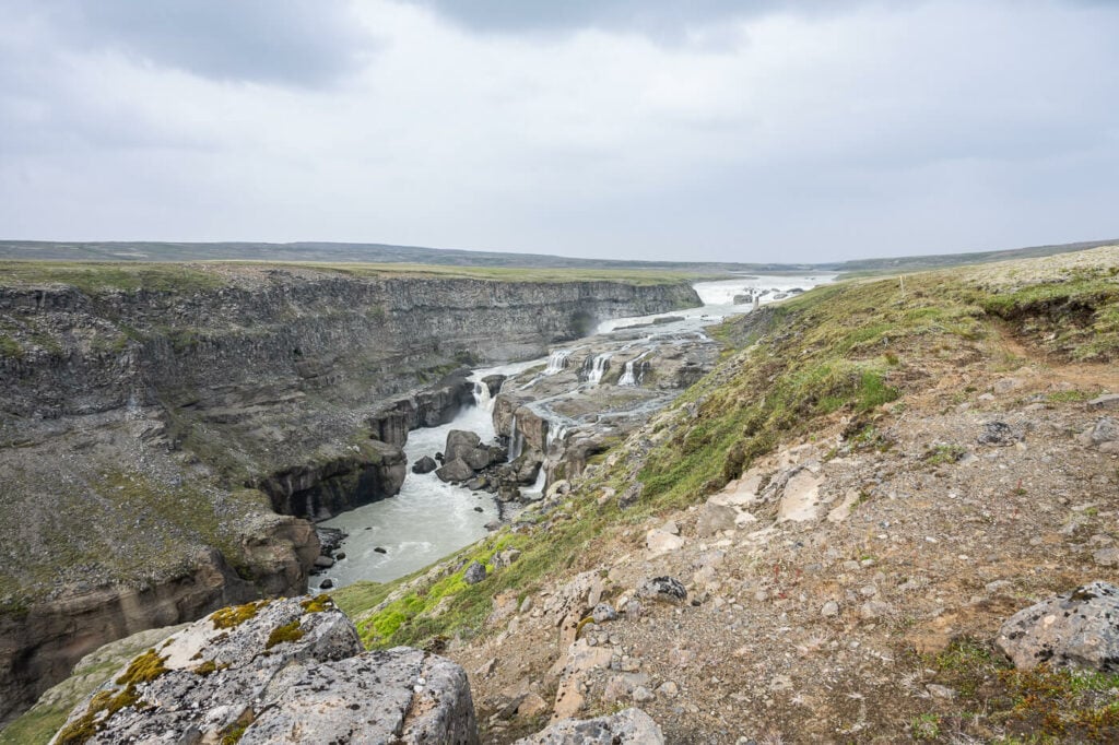
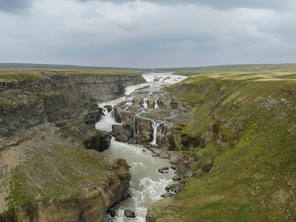
Dynkur, viewed from the Parking area. Epic!
Table of Contents
Overview of the Dynkur Waterfall Hike
As you can see this is quite a short and easy hike, but don’t be fooled by that. This is a hard to get to location.
| Max Altitude | 465 m |
|---|---|
| Distance | 3.62 KM |
| Elevation gain | 90m ↑ / 90m ↓ |
| Hike time | 00:45/ 01:00 Hours |
| Hike Difficulty | Easy |
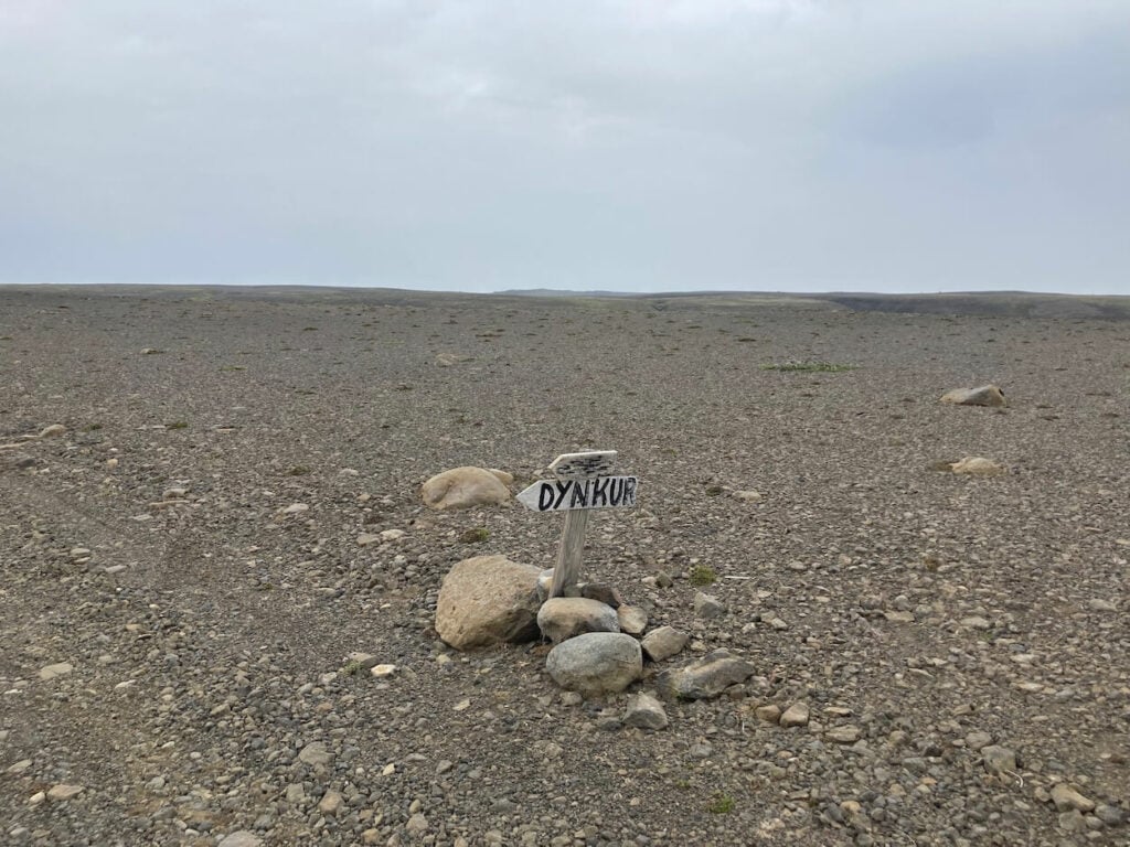
Keep an eye out for the few signs you’ll see along the road.
How to get to Dynkur and Parking
The road to Dynkur isn’t even an F-Road, it’s just a track in the middle of nowhere. the drive isn’t particularly difficult, but if you want to get there I’d highly recommend renting an F-Roads vehicle with a higher ground clearance.
You’d really risk bottoming out and potentially damaging the undercarriage or getting stuck in the middle of nowhere with smaller F-Roads cars. There are also just a couple of signs along the way, so plan the drive carefully to not get lost here.
- Driving Directions: As of 2023, neither Google Maps nor Apple’s will be able to give you directions to this waterfall. So you’ll have to navigate the old-fashioned way, with a map. The best I could find is the Atlaskort 15. Essentially from Road 26, you would have to cross the river above the Tungnaá River. Keep following the road and take the first gravel road on your right, then the first on your left. Here you will see the first sign. It’s still a long way from here though. Again, keep following the road for about an hour and take the second track on your left.
- Parking: There is a small parking area next to the trailhead. You can’t miss it as there is a board/info point and you can see the waterfall from there
- Public Transport: not a chance to even get remotely close to this location using public transportation. I could not even find guided tours to this location.
Also, if you’d like to discover more similar waterfalls, you may also want to check out my eBook “Iceland – the Best Waterfall Hikes and Walks“; with 103 hikes or walks and a total of 172 waterfalls, 32 GPX files, it is one of the most complete and exhaustive resources available on the topic. Good for planning your itinerary as well as discovering new waterfalls while on the road.

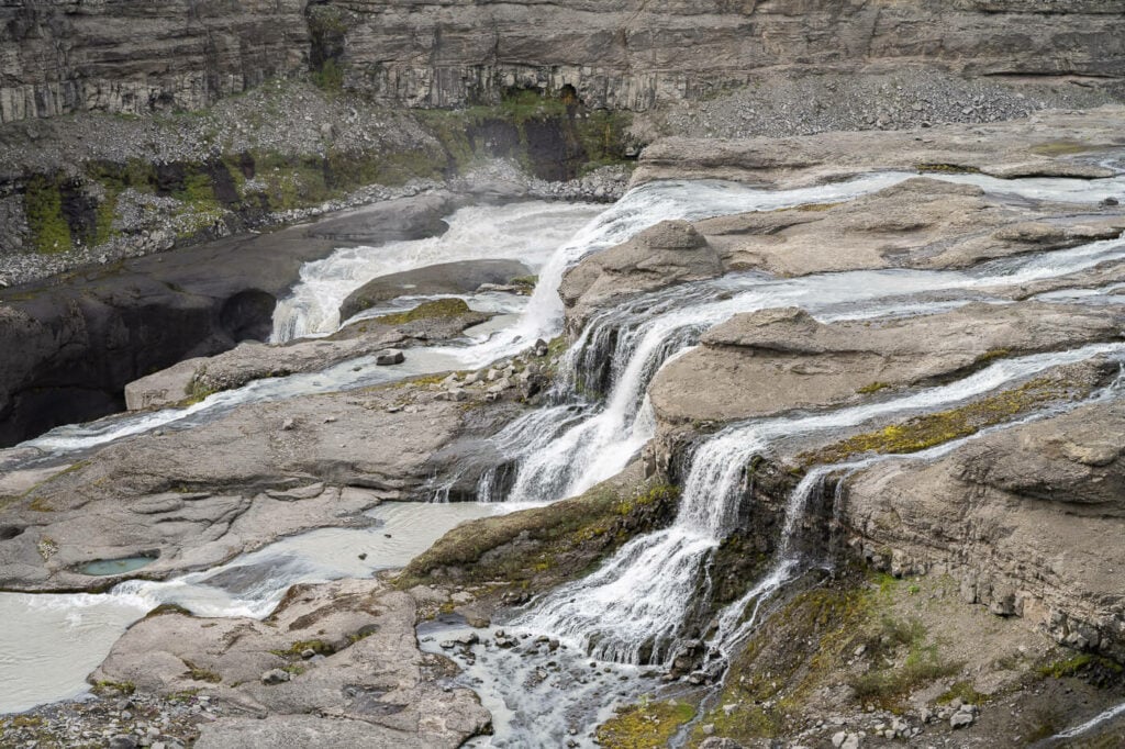
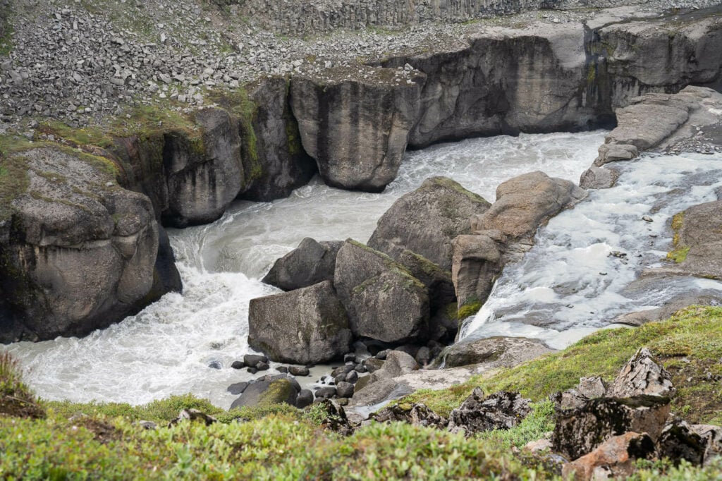
Two of the many steps of the Dynkur waterfall.
The Dynkur Trail
You can’t really miss the trail from the parking area. You’ll have the waterfall right in front of you, two km upstream. And, you’ll also have a nice sign showing you the trail ahead of you, as well as other trails in the area.
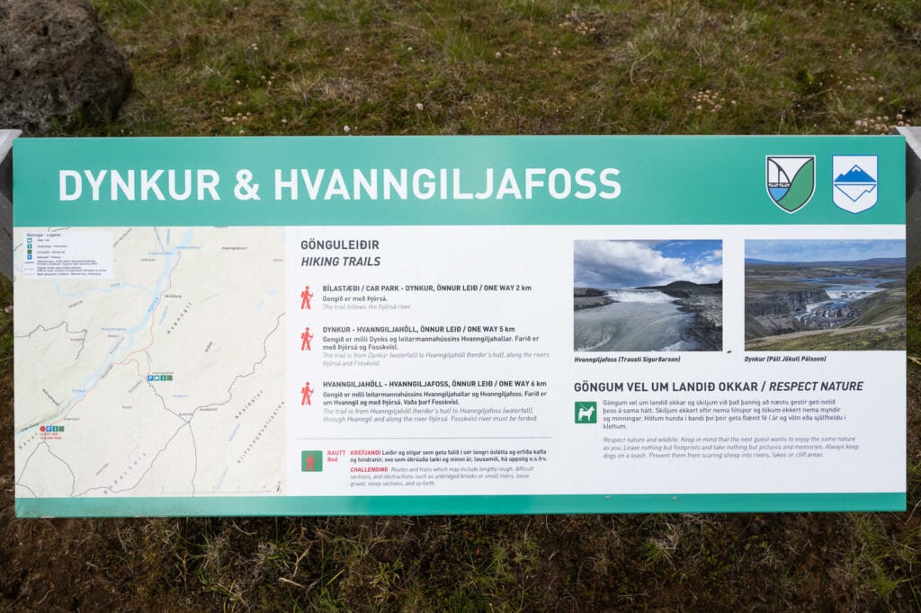
The board at the trailhead.
You can tell this location does not get much traffic; even if the trail is visible it is narrow and a bit overgrown in places. So make sure to stay on the trail. It’s easy to follow and it also is signposted with yellow trail marks.
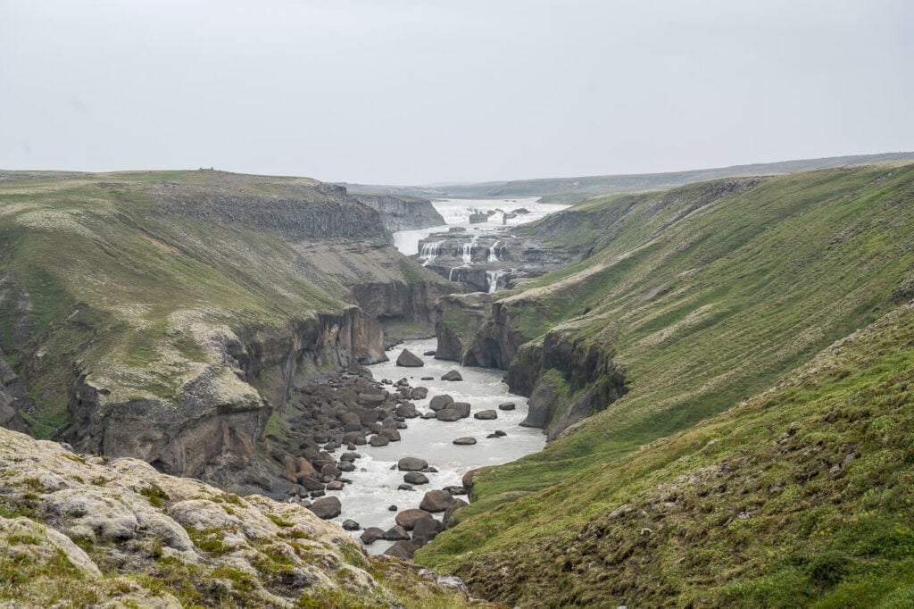
The trail is pretty much flat, with no exposed or dangerous areas. It’s more of a nice walk along the þjórsá river, with fantastic views of the canyon and the waterfall.
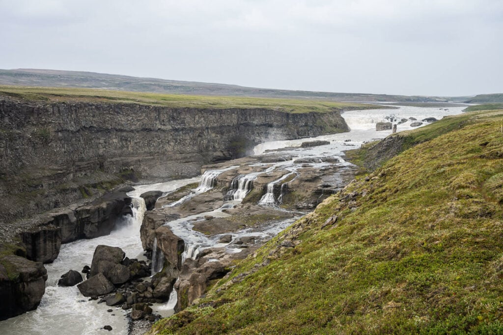
It’s hard to render the size of both the canyon and the waterfall
This is an out-and-back hike, so you can stop wherever you like and hike back to the car for the long drive back.
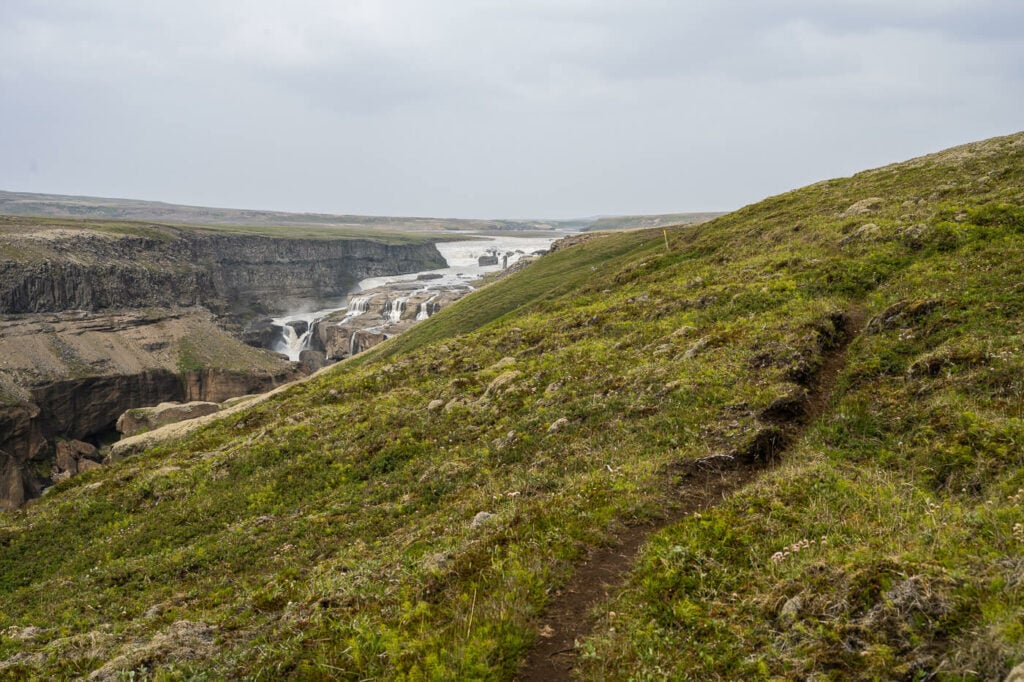
The narrow trail along the Þjórsá river
The Dynkur Waterfall Photos and Photography Tips
The View from the parking area is already a very epic one. Not just because of the waterfall, but because of the whole view, including the canyon the river flows into. You’d need a medium telephoto lens to capture it properly, at least 70mm.
Another view of Dynkur from just below the Parking area. 70mm focal length.
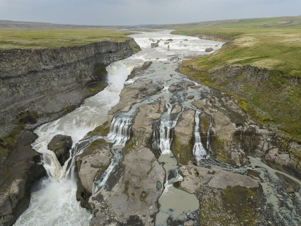
Dynkur is a multi-step waterfall, with several different sections. While it is impressive on its whole, the multiple steps also allow you to capture the smaller waterfalls in detail, so you may want to also bring a longer telephoto lens. The Canyon into which Dynkur falls is also very beautiful and scenic in its own right.
A drone will allow you to capture the waterfall from different perspectives and from inside the canyon, which is not accessible by foot. Be careful though, birdlife in the canyon may not like it. A bird actually tried to “scare” my drone away, so I landed it after that episode to not disturb the wildlife further.
Approaching the lower part of the waterfall.
A beautiful trio of smaller waterfalls
Two of the many steps of the Dynkur waterfall
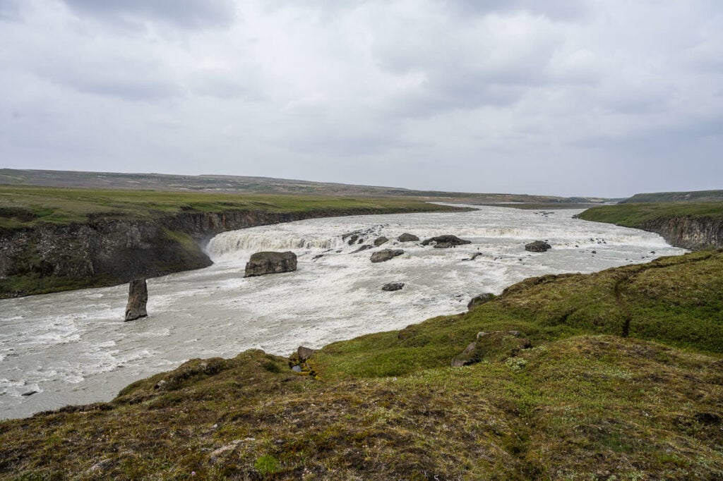
The upper, widest part of the waterfall.


Dynkur, Drone Photo
Dynkur Drone Video
Here’s also some drone footage I managed to capture prior to the “bird attack” episode:
Map of the Dynkur Waterfall Hike
Here is a map of the Dynkur waterfall hike. if you need the GPS file, you can download it from the linked Komoot activity.
Where to stay
You are far away from civilization here, so there really isn’t anything nearby. The closest accommodation would be the Hrauneryjar Highland Centre.
Additional Resources
- Other waterfalls you may want to visit on your way here: Háifoss or Gjáin
- Check out more Photo Hikes in Iceland here.
- Discover the best hiking books and guides on Iceland.
-
Car or Camper Van Rentals
I can definitely recommend two companies here:
- Cars: Blue Car Rental, which is the largest Car rental company in Iceland, and for good reasons. Free Cancellation, Unlimited mileage, 24-hour breakdown assistance, SCDW, CDW, TP, and GP insurance are included in the price. Blue Car Rental is also located within walking distance of the Keflavik Airport, so you can be on your way to explore Iceland right away. I’ve always been happy with my rentals there, which is why I’m happy to recommend their services here on my blog.
- Camper Vans: CampEasy. With CampEasy, you can rent 2WD or 4×4 campers alike. With a raised Chassis, larger tires, and extra insurance with reduced liability for river crossing, their 4X4 campers are the best choice for your trip into the Highlands. Their Website also provides extensive information about roads you can take and instructions on river crossings. Perfect choice for a hiking holiday in the highlands!
These are my two favorite companies in each respective rental area, which I why I am happy to recommend both here. If you also like this blog, booking through them is a great way to support it. I’ll get a small commission fee at no additional cost, so you can essentially support the running costs of this blog for free too.


Leave A Comment