Mythen Region Snowshoe Hike. Furggelen Trail, Schwyz, Switzerland
The Mythen Region, or the region around the Grosser and Kleiner Myhten, is a great location to visit for some hiking in Summer and for a Snowshoe Hike in Winter. This Snowshoe trail offers some fantastic views of the surrounding mountain and the Lake Lucern Area.

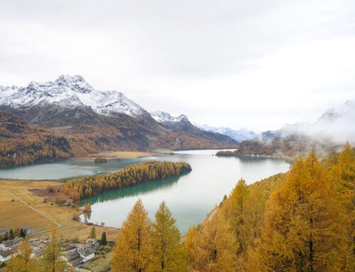
View of Lake Luzern from the Furggelen Trail.
I have been living in Switzerland for more than five years now, and it is amazing how many beautiful places there are that are virtually unknown outside of the country. The Mythen region is one such place.
The Mythen region is quite popular with locals and very much a local tourist area, though I feel it gets lost in the middle of all the other attractions in the area.
Still, this is one of the best options if you are looking for a moderately hard Snowshoe trail in the Lake Lucerne area or something close to Zurich.

Snowshoeing toward Furggelenstcok
Table of Contents
Overview of the Furggelen Snowshoe Hike & Map
This is a moderately difficult snowshoe trail, mostly due to the elevation gain, made of several uphill and downhill sections. Also, it’s quite a long trail, but you can make it shorter by taking the Cable Car in Brunni.
Do check snow conditions before going there. You can do so in the Switzerland Mobility app, or on the Switzerland Mobility Website. The trail is fully marked, and the trail number is 818.
Also, if you are wondering, you can rent snowshoes on-site. There are a couple of shops renting Winter Sports equipment.
| Max Altitude | 1,650 m |
|---|---|
| Distance | 9.90 KM |
| Elevation gain | 680 m ↑ / 680 m ↓ |
| Hike time | 03:43/ 04:30 Hours |
| Hike Difficulty | Moderate/Hard |
Here is the Map of this Snowshoe Hike. You can download the GPX file for free from the activity linked below.
How to get to the Furggelen Snowshoe trailhead and Parking
The trailhead is quite easy to reach. It’s located in Brunni, in the Canton of Schwyz, in Central Switzerland.
- Driving Directions: from Zurich or Lucerne, you can drive directly to Brunni. Do note there’s more than one Brunni, so make sure you set your directions to Brunni in the Schwyz Canton. It takes a little over an hour to drive there from either Zurich or Lucerne.
- Parking: there are a few different parking areas in Brunni. Specifically for this trail, I’d recommend parking at this spot. Parking is paid in the whole area.
- Public Transport: This is doable by public transport. Take the train to Einsiedeln, and from there, you can take a bus to Brunni. Alternatively, if you are in Schwyz, you can take the Rotenflue Cable Car from there

A barn by the trailhead in Brunni, next to the parking area. The mountain in the background is the Grosser Mythen.
The Furggelen Snowshoe Trail
The trail can approximately be divided into three main sections. If you decide to stop at Holzegg and take the cable car, you can ship the last section. Also, the trail is a loop so you can do it both ways, but I’d recommend doing it clockwise, in the order I describe below.
The main reason for this that are the views. Especially when done in the morning you can hike up the mountain and watch the Grosser and Kleiner Myten catching more and more light as the sun rises higher in the sky.

Early morning light on the grosser and Kleiner Mythen
Then a bit to save the best for last, the view toward Lake Luzern closer to the Holzegg Cable car station. There you can also take the cable car down if you prefer to, an option you don’t have when hiking the trail the other way around.
Anyway the view from there is just epic.

From Brunni to the Furggelenstock Summit
The first part of the trail is the hardest and where most of the elevation gain is. You initially leave the parking area following a narrow road, until you reach a deviation marked in pink.
This is where the trail enters a forested area and keeps going uphill to the Furggelenstock summit. The view will open up here and there toward the Grosser and Kleiner Mythen, but even without the view, this part of the trail is really enjoyable.

Grosser Mythen, view from the trail.

Aerial view. the first part of the trail goes through that forest.

Aerial view in the opposite direction. the Furggelenstock is the mountain on the top right.
You’ll be snowshoeing through the forest, in almost total silence if not for your own noise, and maybe some birds. The last part before reaching the Furggelenstock summit is the steepest part of the trail. the view will gradually open up to reveal the 360- degrees panoramic views of the mountainous landscape around.
This is a great place for a stop, a snack, and a warm drink before continuing.

Furggelenstock.

View from the Top.
From the Furggelenstock to Holzegg
This is the middle section of the trail, or the last one, should you decide to take the cable car from Holzegg back to Brunni.
From the Furggelenstock Summit, most of the trail goes back downhill except for a few sections where you have to climb back up.
The view on the opposite side of the Furggelenstock is still extremely nice. The descent, initially quite gentle, will progressively become steeper without ever becoming too demanding.


The trail then crosses some sky slopes before climbing back up toward the Holzegg Station.
Right before the Cable car station, you will reach a hut called “Skyhaus Holzegg“. It’s a mountain hut/bar/restaurant where you can enjoy this magnificent view of Lake Luzern and the snow-capped mountains around it. And, of course, a warm drink or a meal.
you also have quite a good view of the beautiful Grosser Mythen Mountain.

View of Lake Luzern.

The mountain hut “Skyhaus Holzegg”, close to the Holzegg cable car station. Grossery Mythen in the background.

Small snow discharge from the side of the Grosser Mythen.
From Holzegg to Brunni
The last part of the trail follows the Grosser Mythen summer hiking trail back down into the valley to Brunni. It’s easy-going here. The trail is entirely downhill, and it’s the same summer hiking trail that leads from Brunni to Holzegg, on the way up to the Grosser or Kleiner Mythen.

Another mountain hut with the Grosser Mythen in the background.
The trail then closes the loop in Brunni, on the opposite side of the small village, so you’d have to cross the small village on foot to close the loop.
Mythen Region – Winter Photos and Photography Tips
I think there are two main points of interest in terms of landscape photography on this Snowshoeing trail.
The first one is the view of the Grosser and Kleiner Mythen in the first section of the trail. Both are gorgeous mountains, sticking out dramatically with their rock faces from an otherwise gentle, hilly landscape.
They are quite a popular attraction in central Switzerland, but otherwise, they are quite underrated in my opinion.


Grosser Mythen lit by the early morning sun.
The other point is the panoramic view close to the Holzegg station. the views from that side of the trail toward Lake Lucerne are spectacular in winter, with the contrast between the snow-caped mountains and the “warmer” landscape down below in the valley. Of course, assuming the valley is snow-free.


Where to stay
There are a few accommodations around Brunni or in Schwyz. However, the Mythen Region is typically a place you’d visit for day trips, especially if you are already staying in the Zurich or Lucerne Area.
Additional Resources
- In case you didn’t know, you can hike to the top of both the Kleiner and the Grosser Mythen. Both are well worth it.
- For a comprehensive overview of Hikes in Switzerland, check out my main Switzerland page.

Leave A Comment