Rifugio Nuvolau and Averau Loop Hike, Dolomites, Italy.
If you are looking for a hike in the Dolomites with fantastic views over multiple points of interest along the same trail, the Rifugio Nuvolau and Averau Loop Hike should be on your list. Very high actually. the reason is simple – This hike will get you to some amazing landmarks and views in one loop.

Ra Gusela on Passo Giau

Le Cinque Torri, view from the trail to Rifugio Nuvolau.
Passo Giau, Ra Gusela, le Cinque Torri, Tofana di Rozes, and the Rifugio Averau and Nuvolau are all landmarks on the loop hike around rifugio Averau and Nuvolau. So if you want to see all of them and more in one go, you can do it on this hike.
You also have the option to start the hike at different trailheads, either le Cinque Torri or Passo Giau. The duration and length of the hike are the same from both trailheads, except if you hike from the Cinque Torri to Le Cinque Torri, which I’ll describe below.

Rifugio Nuvolau, built on top of the homonymous mountain.
Table of Contents
Overview of the Rifugio Nuvolau and Averau Loop Hike & Map
Overall the trail is moderately difficult, well signposted although there’s a bit of a trail maze around Rifugio Scoiattolo, next to Le Cinque Torri. I’ll describe the trail starting from Passo Giau since that’s where I began my hike. Also, I did the hike clockwise
I camped there in my van to catch both sunset and sunrise from Passo Giau, before doing the hike early the next morning. So I did, and after catching sunrise and some breakfast, I set you toward Ra Gusela in some beautiful morning light. If you also are a photographer, I’d recommend this option. if you are not a photographer I’d recommend it too as the views at sunrise are spectacular.
| Max Altitude | 2,574 m |
|---|---|
| Distance | 8.8 KM |
| Elevation gain | 620m ↑ / 620 m ↓ |
| Hike time | 03:15/ 03:45 Hours |
| Hike Difficulty | Moderate |
Here’s the map of this hike. You can download the GPX file for free on the activity linked below.

Rifugio Nuvolau
How to get to the Nuvolau trailhead
First, you’d have to see from which trailhead you want to start the hike. You have two main options here you can either start from Le Cinque Torri or Passo Giau. I started my hike from Passo Giau because parking there is free and there’s no need to catch a chairlift.
Both locations are about a 20-25-minute drive from Cortina d’Ampezzo. To reach Le CInque Torri Trailehad, drive toward Passo Falzarego. Or the other, Passo Giau. Here are both options.
Rifugio Nuvolau from Le Cinque Torri
From le Cinque Torri you also have two options. You can either park (paid parking) by the chairlift’s mountain station and take the chairlift or hike up to Le Cinque Torri from there.
If you want to hike up, you should add about 1.6km/310m elevation gain to the hike (one way). This is a good option if you want to spend more time on the trails and perhaps view the trenches around Le Cinque Torri.
Rifugio Nuvolau from Passo Giau
Passo Giau is right by the other trailhead and parking is free. This is the option I chose. I recommend getting there rather early in the morning. The light and the views are, of course, better in the early morning light. But the main reason is to find a parking spot. It can be a bit of a challenge to find one on busy summer days.
Once you park, you can walk toward Ra Gusela (the very recognizable mountain towering above the pass). Then walk past the Berghotel Passo Giau, the hut at the top of the pass. Keep going until you see the white-red trailmarks.
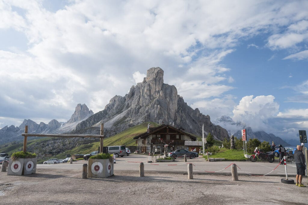
Parking area at the top of the Passo Giau. The Nuvolau is one of the smaller peaks behind Ra Gusela (the mountain in the center).
If you are travelling by public transport, you can get to both trailheads using the Dolomiti Bus service. Check dolomitibus.it for the detailed schedule.
Rifugio Nuvolau and Averau Hiking Trail
I hiked the loop trail to Rifugio Nuvolau clockwise. So after the Nuvolau hut, I took the trail to my left and continued through a boulder field for the next 20 minutes or so. This part isn’t difficult, but kind of slow going because of all the big boulders hiding the trail.
To be honest, the trail marks are a bit difficult to see in this first section of the trail. Sometimes the trail multiplies into a few different branches that go out in different directions. Just keep going around the mountain trying to keep the same elevation, until you’re out of the boulder field.

View of Passo Giau’s Western side, from the trail to Rifugio Aver
Getting to Rifugio Averau
Once you’re out of the boulder field, continue to follow the trail until it splits. To your left, the trail will join a gravel road road that leads to Rifugio Averau. To your right, the trail will climb up on the side of the mountain, going through a moderately exposed section with loose rock.

The steep trail up to Rifugio aver. The gravel road (visible on the right side) is an easier alternative.
If you take the road, it’s an easy but longer walk to Rifugio Averau. Probably about 10-15 minutes more compared to the steep trail. On the other hand, if you take the steep trail there’s a bit of scrambling involved, and there are a lot of loose rocks. Take the path you are most comfortable with, both lead to the same place, Rifugio Averau.

Approaching Rifugio Averau.

View from the saddle between Averau and Nuvolau, with the Tofana di Rozes in the middle.
From Rifugio Averau To Rifugio Nuvolau
Rifugio Averau is located on a saddle between Mount Averau and Mount Nuvolau, just below the Averau.
The Rifugio Nuvolau isn’t in sight from there, but it will be up the mountain to your right. It’s mostly a trail on bare rock, not a difficult one. It took me about 20 minutes to get there. From up there the views are already spectacular.

Leaving rifugio Averau to continue the hike to Rifugio Nuvolau


You can get a good sense of the vastness around you. Mountains in every direction as far as the eye can see. So much so that Le Cinque Torri almost looks like a small geological feature in this landscape.
Soon enough you’ll catch the first glimpse of Rifugio Nuvolau. Once you reach it, you can walk to the opposite side where you have a good view of Ra Gusela, from the back. That’s the same mountain that towers above Passo Giau.

Approaching Rifugio Nuvolau.

Rifugio Nuvolau.

Ra Gusela, opposite side to Passo Giau.
Rifugio Nuvolau is also a good place for a coffee and some cake – sure enough I got myself some too.

Coffee and cake with a view at Rifugio Nuvolau.
From Rifugio Nuvolau to Le Cinque Torri
With the views and the cake in, it’s time to descend toward the Cinque Torri. the distance is a little more than from Rifugio Averau to Nuvolau. It’s mostly on the same trail, except you need to keep the right in order to descend toward le Cinque Torri and Rifugio Scoiattolo.
If you are doing this hike to view Le Cinque Torri it’s also worth spending a bit of time around them to view the trenches and enjoy the views from there too. I visited them before (see my post on catching the sunrise from Le Cinque Torri), so I went straight to the next part of the trail, to close the loop back toward Passo Giau.

Rifugio Scoiattolo and Le Cinque Torri.
From Le Cinque Torri to Passo Giau
This is the last leg. From le Cinque Torri, the trail initially descends into a narrow valley. Not very steep at first, but steeper toward the lowest point of the hike. From there, you then have to gain elevation again to reach Passo Giau.
It’s about a 100-150m elevation again. It’s not much, but being at the end of the hike it can feel harder after all the elevation gains and losses on previous stretches of the hike.
Make sure you look back form time to time while hiking toward Passo Giau, the views are worth it.

Looking back on the trail to Passo Giau.

Again, Looking back on the trail to Passo Giau.

Yet one more view toward the opposite direction of Travel of La Tofana di Rozes.

Rifugio Nuvolau and Averau photos and Photography Tips
My first tip would be to do this hike in the early morning. Even better, plan to be at either Le Cinque Torri or Passo Giau for Sunrise. Provided the right weather, Sunrises can be spectacular at both locations. This is what I captured that very morning at Passo Giau.
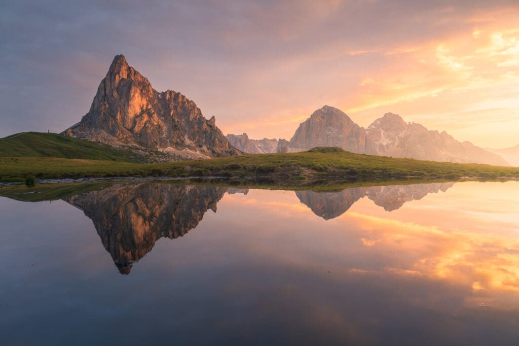
Sunrise above Passo Giau.
My second tip would be to bring a lens on the long side too. On the wide side, 18-24mm (full frame) should be more than enough. However, a longer lens is what will allow you to capture the more subtle details and farther away landmarks.
If you enjoy doing landscape photography with telephoto lenses, the loop hike around Rifugio Nuvolau is a great choice. I kept switching lenses along the trail, while I was trying to document it and also do some landscape with the telephoto lens. There are plenty of beautiful rock giants around to capture.


Lastly, do this for sunrise, sunset, or during the golden hour. With the views wide open in every direction and the many beautiful landmarks around, you’re going to have fun shooting here. I have been to Passo Giau for sunrise/sunset several times, as well as at le Cinque Torri and it’s always been epic.
Where to Stay
Well, one of the two Rifugi if you can. Especially Rifugio Nuvolau, to catch the views at Sunrise and Sunset. Rifugio Nuvolau can be booked only from mid-June to mid-September, usually.
Alternatively, you can also consider one of the Rifugi next to Le Cinque Torri, watching Sunrise/Sunset from there is also well worth it. Or stay around Passo Giau, like I did.
Cortina d’Ampezzo is the town with more choices and the drive to the trailhead from there isn’t long, about 30 minutes. Generally speaking, Cortina is a great base to explore this corner of the Dolomites too.
Additional Resources
- More Nearby Hikes: Le Cinque Torri, Lago di Federa, Lago di Limides, or just check out the best viewpoints on Passo Giau!
- Check out my main page about Hiking in Italy.
Leave A Comment