Hiking to the Fagradalsfjall Eruption in Meradalir – Iceland
Hiking to the Fagradalsfjall Eruption in Meradalir and witnessing a Volcanic eruption like the current one is a once-in-a-lifetime experience for most of us.
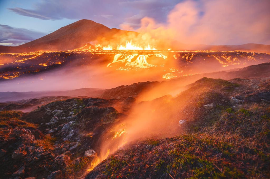
Burning moss at the eruption site
I remember vividly when I booked my ticket for Iceland in 2021, counting the days until departure. I couldn’t wait, like a kid going to an amusement park.
Seeing such an eruption is almost a life-changing experience. It’s earth in the making, and no photos or videos can do justice to the scale of a similar event. Still, a volcanic eruption such as this is a hazardous event and a number of precautions should be taken.
In this post, I will share my tips and recommendations to get the most out of a visit to the eruption site. If you are planning a visit to the Volcano or if you already have a ticket to Iceland in your hand, read on. I was lucky enough to view both eruptions (2021 and 2022), and here I’ll share my tips to enjoy this event. Also, I’d love to hear about your experiences in the comments below.
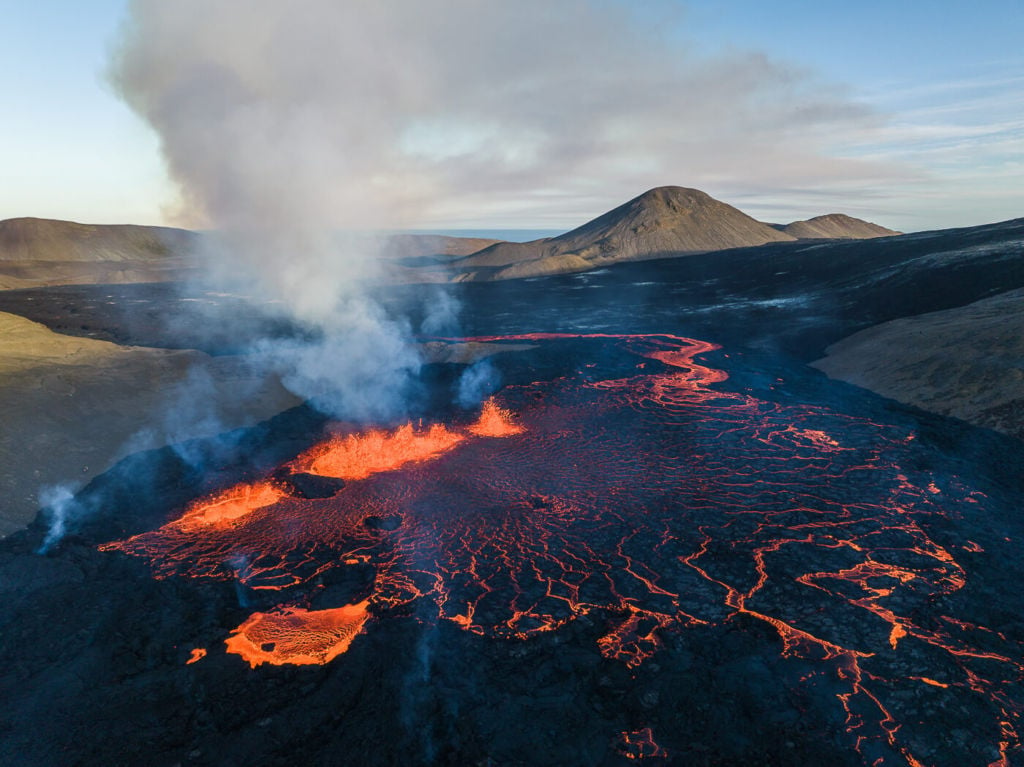
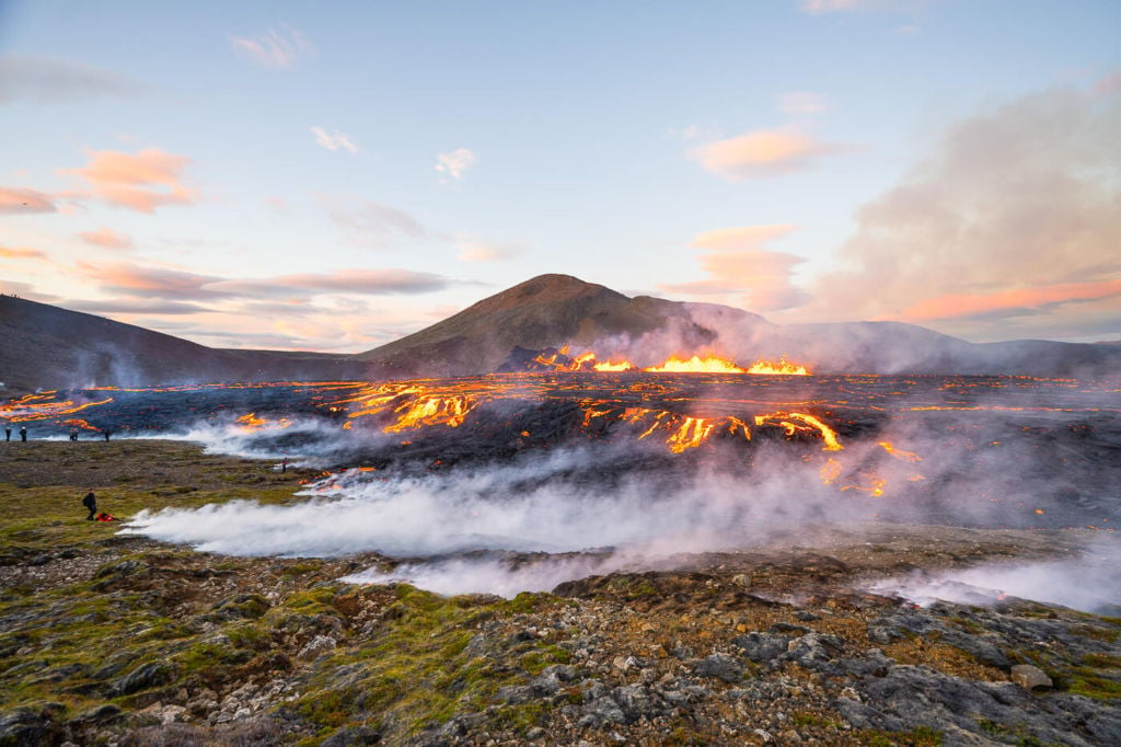
Fagradalsfjall eruption drone view.
Going to Iceland? Get a Car Rental Discount!
As a reader of The Photo Hikes, you get a 5% discount on your car rental when booking with Blue Car Rental through this website. The discount will be automatically applied to the booking through the following link
Fagradalsfjall Eruption – updates
I’ll do my best to keep this section up to date. Even though I am no longer in Iceland, I will still follow the eruption closely.
July 2023 update: a new eruption by Litli-Hrútur has started. Click here for the 2023 Volcanic Eruption.
Last update: Please note the Eruption has ended. Also, the hiking trail to the eruption site in Meradalir has been completed.
Saturday, August the 20th: since August the 20th, the eruption seems to have stopped. There still is a bit of “bubbling” lava inside the crater, but nothing resembling a proper eruption. While it will take several weeks to declare the eruption has ended officially, it does seem the current event has come to an end for the time being.
Monday, August 15th: there’s a new, very cool, interactive 3D map on the Visit Reykjanes website. This shows trail A up to its viewpoint.
Tuesday, August the 9th: the area is still closed due to bad weather and should reopen tomorrow, the 10th of August. Check official sources for confirmation. Also, Children under twelve can no longer access the eruption site (source). However, as far as I understand, the trail is currently being improved. Keep in mind this will remain a long and challenging hike.
Saturday, August the 6th: I hiked to the eruption for the third time. I followed the trail marks all the way to the eruption site, and it took me about one hour and fifteen minutes to get there. Here’s the GPS track – you can download it from the Komoot activity:
The new trail is a little shorter than the one that most people followed on days one and two, but this was also my third hike to the volcano, and I was already familiar with the terrain.
Experienced hikers will probably take anywhere between one hour and one hour and thirty minutes to get to the first viewpoint above the eruption. Generally, however, I would still plan at least two hours to get there, as you will pass by the old crater and lava field, which are also quite a sight.
Thursday, August the 4th, 2022: as of today, the trail has been staked out all the way to the hill above the eruption. This makes the hike easier. Still, the trail goes over very rocky and uneven terrain.
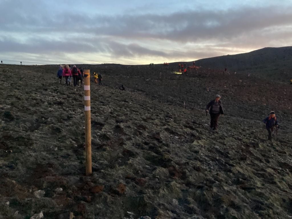
Photo of the poles marking the trail.
Wednesday, August the 3rd, 2022: I am currently on vacation in Iceland; I decided to visit the eruption on Day 1 – taking all the risks that this implies. In this post, I’ll share my experience with those in the same situation who may want to view the eruption too.
Also: this information is going to get outdated quickly, so make sure to check the latest updates on the following websites:
- Safetravel.is
- Visit Reykjanes website here and here.
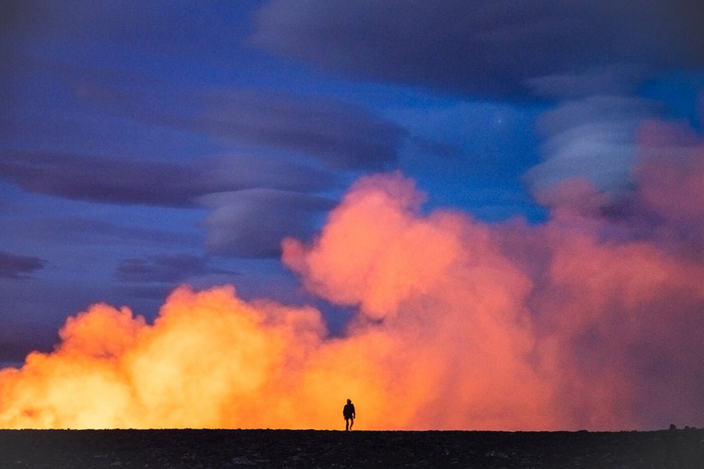
Hiker walking at the eruption site.
Things to be aware of before Hiking to the Eruption Site
Viewing a volcanic eruption is something very unique and special. A once-in-a-lifetime event for most of us. Especially something like the Fagradalsfjalls’ eruptions, which have been rather “tourist” friendly, compared to other eruptions.
To enjoy the sight of the erupting volcano, make sure you familiarise yourself with the risks before setting out.
Even if the trail has been staked out all the way to the eruption site, the hike is not an easy one. The path is steep and slippery in places. There is the old lava from the 2021 eruption; it is hollow in parts, and if you set foot on it, it may break. Do not cross it.
If you are planning to go there, please:
- Always check whether the hiking trails are open to the public before heading there: trails can be occasionally closed due to bad weather, or due to maintenance/improvements to the existing trails.
- Listen to the local Authorities and SAR’s advice. Constantly check the websites linked above. The SAR team has been doing an amazing job at keeping people safe and helping those who needed. Listen to them.
- Check the Gas dispersion forecast and the weather forecast before heading out. Avoid the area if the wind is blowing gases onto the trail or if bad weather is forecasted during the time you plan to visit. The Gas dispersion forecast can be checked here and the weather forecast here.
- Do not bring kids or dogs. Currently, children under 12 are not allowed to access the eruption site. Toxic gases collect close to the ground, and they are more at risk if inhaling them. Check the official website for updates on this recommendation.
- Wear proper hiking gear, sturdy boots and use hiking poles. The trail goes over rugged terrain and is steep and slippery in places. Especially if it’s been raining.
- Bring a headlamp, especially if you go there late in the afternoon. Time will fly while watching the eruption and days are getting shorter and shorter. At this latitude, they also get shorter much faster.
- Bring a battery pack for your mobile. You will probably spend 5/7 hours out at the eruption, taking a lot of photos and videos and your battery is probably going to drain quickly. You will want to have a charged mobile in case you need it for any emergency, especially if you get lost or if you are hiking alone.
- Bring layers of warm clothes, gloves and a beanie. While the fresh lava provides some heat from afar, it is cold, and with the Windchill, it’s even colder.
- Take more than enough water and food with you. You will want to refuel during the hike. Time will fly by watching the eruption.
- Do not walk or try to step on the Lava! This may sound obvious, but it is not, sadly. This also applies to the lava from the 2021 Eruption. The 2021 lava field is still releasing toxic gasses. There may also be areas that could collapse.
View of the eruption site from one of the uphill viewpoints
How to get to the Fagradalsfjall Volcano Eruption in Meradalir
While it is likely that local authorities will build a trail to the new eruption site at some point, there currently is no official trail However, the SAR team planted poles to mark the best possible path to the eruption site. This made the hike easier compared to days one and two of the eruption. Also, this is the map from the Visit Reykjanes official website.
If you are looking for care rentals recommendations, I can definitely recommend two companies here:
- Cars: Blue Car Rental, which is the largest Car rental company in Iceland, and for good reasons. The price includes Free Cancellation, Unlimited mileage, 24-hour break assistance, SCDW, CDW, TP, and GP insurance and more. Blue Car Rental is also located within walking distance of the Keflavik Airport, so you can be on your way to explore Iceland right away. I’ve always been happy with my rentals there, which is why I’m happy to recommend their services here on my blog.
- Camper Vans: CampEasy. With CampEasy, you can rent 2WD or 4×4 campers alike. If you prefer an off-the-grid vacation, they offer both 2wd and 4×4 campers suitable for most Highland roads.
These are my two favorite companies in each respective rental area, which I why I am happy to recommend both here. If you also like this blog, booking through them is a great way to support it. I’ll get a small commission fee at no additional cost, so you can essentially support the running costs of this blog for free too. If you do, you have all my gratitude!
If you prefer to book a tour, you can choose from several different options. Check some of the available Volcano tours here.
Fagradalsfjall Volcano Eruption Parking
As you can see in the map above, there are two parking lots (Parking 1 and Parking 2), both paid. Parking costs 1,00 ISK per day, approximately 7-8 USD or EUR.
You can pay using the Parka app. You can download it from the Play and Apple stores. Once downloaded, you will need to enter the car’s license plate, add some form of payment (credit card) and select the parking.
To select Fagradalsfjall, you will first need to click on “Tourist Destinations.”

Select Tourist Destinations
Then, Select “Fagradalsfjall Volcano” from the list.

Scroll to “Fagradalsfjall Volcano”
Alternatively, you can also pay on the Parka website if you do not want to install the app.
Hiking to the Fagradalsfjall Volcano Eruption in Meradalir from Parking 1
The best option is to leave the car in Parking 1 and take trail A from there. As of Thursday the 4th of August 2022, the trail has been staked out all the way to the Eruption site. This means it is easier to hike to the site now. Still, this does not mean it is an easy hike.
The hike from Parking 1 is about 10-11Km in total. As I mentioned, this is a hike on rugged terrain. If you are not used to that kind of distance on challenging terrain, hiking to the eruption site may not be a good idea, as you would be putting yourself at risk.
Hiking to the Fagradalsfjall Volcano Eruption in Meradalir from Parking 2
It is also possible to hike from Parking 2, which is what I did on the first day of the eruption. This makes the hike a bit longer, adding a good 2.5km compared to starting the hike in Parking 1.
The hike from Parking 2 was 8km in total – one way only. This means it’s a 16km roundtrip. This is because, from Parking 2, you will have first to reach the trailhead of path A, next to Parking 1.
Do not hike Path C. Several people did this yesterday and then decided to cross the old lava field from the 2021 eruption to get to the new eruption site. This is extremely dangerous; there are still toxic gasses, and the lava is unstable with areas that may collapse. Do not do this.
However, you can still view the eruption from Path C, but it will be farther away, and the hike isn’t any easier.

View of the Fagradalsfjall eruption from path C. The eruption will appear quite small and very far.
Path B is no longer in use.
Best time to visit the Fagradalsfjall Eruption in Meradalir
Plan the hike to get to the eruption site before sunset if you can. As an indication, It will take most people two or two and a half hours to get there.
Why should you be there before sunset? Because then you can watch the eruption and lava field glowing as the light from the sun dims. The lava will shine brighter during the blue hour and at dusk. All the movements and the patterns in the Lava will become more visible. Such a sight is truly unforgettable.
Alternatively, and if you prefer to avoid the larger crowds, you can do the hike early in the morning. I was there at 10:30 AM on Saturday the 6th of August, 2022, and there were far fewer people compared to the evenings of the 3rd and 4th of August.
Photographing the Fagradalsfjall Eruption in Meradalir
If you made it to the eruption site, you would enjoy what is probably a once-in-a-lifetime natural show. You’ll have quite a lot of fun taking photos too. Still, always be mindful; this is a dangerous location. Do not get too close to the lava.
A note on drones; all the usual local regulations apply. Plus, please check the official rules here.
Fagradalsfjall Eruption in Meradalir – Photo Gallery
Here are a few shots from the current eruption. I will add more photos as I process/take more. Please get in touch with me first if you would like to use any of my images.
View of the eruption site from one of the uphill viewpoints.

View from the hill next to the eruption.
Drone view of the Fagradalsfjall Eruption in Meradalir.

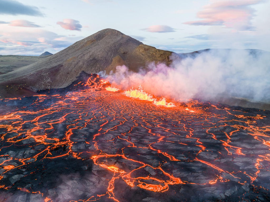
Lava fountains from the fissure eruption.
Burning moss at the eruption site.

Lava show during the blue hour.
Hiker hiking back from the eruption site.

Aerial view of the lava in Meradalir.

Enjoying the show.

Anita group of people looking at the Fagradalsfjall eruption from a hill.

Lava fountains at night.

Night view of the eruption and lava field – shot with a drone.
Also, check out this short clip on Youtube:
Additional Resources
- Check out my main page on Hiking and Hiking suggestions in Iceland
- if you want to visit another geological wonder on the Reykjanes peninsula, you can go for the Seltún and Hverafjall Hike.


Thanks again for such a great and detailed post. I appreciate all of them!
Thanks Veronica, glad you liked it! As of yesterday, they have staked out the trail all the way to the hill above the eruption – definitely easier to hike up there now.
These are great!!
We were in Iceland 5 years ago after the last eruption.
We never got to see any live action, but did tour some of the lava caves.
Would love to have been able to be there this time around!
Keep up the great picture posting and passing along of information!
Thanks so much Douglas! Yeah, Iceland is a rather unpredictable country – not only its weather :)
Great information to prepare for my hiking trip this Sep, thanks very much!
Thanks, Glad it helped!
Your videos and footage are excellent, thanks for sharing. We hiked to view the Meradalir volcano on Aug 6. It was an incredible, once in a lifetime sight to behold! We viewed it from the top of the mountain looking down towards the flowing ‘rivers of lava’. It appeared to be quite high but was also very steep. As an estimate, what would be the approximate distance from the top where we viewed the volcano down to the fissures in the earth? ie. in relation to number of stories in a high rise building. Thanks for your reply.
Thanks for taking the time to share your experience Valerie! It is indeed a sight to behold. Coincidentally I was there on Aug 6 too – my last visit.
Interesting question! I checked the gps data from my hike, and it looks like the height difference from the top of the hill down to the lava field was about 70m. Assuming 3m as the average story height, we would be around 23 stories.