The Sveinstindur Hike – Iceland
Located in the central Highlands of Iceland, the Hike to Sveinstindur offers fantastic views over Langisjór, and this location’s remoteness makes for a unique hike. Apart from the beauty of this landscape, other factors add to the experience.

The Langisjór lake, viewed from the top of Sveinstidnur
Two things struck me the most—the vastness of the landscape around me and the silence. Similarly to any desert area, hiking to Veinstindur has a sort of “Zen” side. Such an immense landscape with virtually no sound around boggles the mind. The peace and the quiet in such an immense landscape make for an unforgettable experience.
At times I was afraid I was making too much noise hiking up the mountain. I was as worried about not damaging the vegetation as not breaking the silence. I won’t add too many words to this; this must be experienced first-hand.

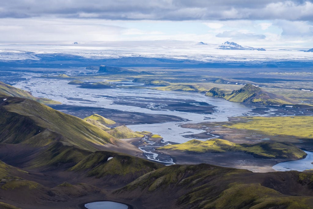
South view, toward Mýrdalsjökull
As for the landscape, I will add one more thing. On a clear day, you will simultaneously see both the Vatnajökull ice cap to the northeast and the Mýrdalsjökull ice cap to the southwest. Yeah, you can see that much and more!
You can also watch the video I made on this hike to get an impression of that vastness:
How to get to Sveinstindur and Overview of the Hike
Please note: there are several rivers to cross by car to get to the hike’s starting point. You will need to rent a car suitable for f-roads, but even them crossing rivers is at your own risk. No insurance will cover any potential water damage.
- How to get to Sveinstindur & Parking: this area is remote, and getting there requires time and crossing a few rivers by car. The first road you would have to drive to get here is road F208, either from the north or south side. Then, you would have to turn into Road F235 and continue until you reach the Langisjór info point. Don’t park there. Instead, continue for a few hundred meters until you reach a small parking area. This is the start of the hike I am describing here.
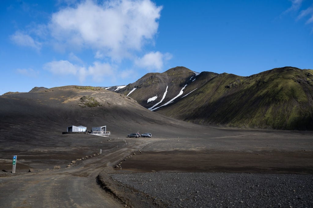
The Langisjór info point. When you get here, keep driving to the next parking area.
- Start of The Hike: There are actually two trails leading up to the summit of Sveinstindur. The shortest one starts at the parking area mentioned above. It’s also possible to continue driving for a few hundred meters more, possibly one kilometre or so and turn to your left into another dead-end track, where you can park the car and hike up.
- Photography & Scenery value: the views from up on a clear day there are truly unforgettable. This location is excellent for these lens landscape shooting.
- Hike Difficulty: easy to medium. This short hike is relatively steep in places, but the ground is soft and crumbly. That makes it a little more challenging than it looks.
- Tip: there are several hiking trails around Langisjór. I was planning to do more hiking there, but I spent so much time on Sveinstindur that I did not have time left for more hikes that day. Considering the remoteness of this area, it’s well worth exploring it as much as possible.
The Sveinstindur Trail
The hike I’m describing here starts from the first parking area closer to the Langisjór info centre. The hike is relatively easy. The only minor challenges are some pretty steep sections (no scrambling required) and the soft/crumbly terrain.
| Distance | Elevation gain | Hike Time |
|---|---|---|
| 4.39km | 530 m. | 2:30/3:00 Hrs |

Sveinsindur Parking area
The trail is already visible from the parking area, and the trail marks are painted yellow. The first part of the trail is relatively steep. Here the terrain will already be quite soft.

The first part of the trail. Sveinstindur’s summit is behind the upper-right corner.
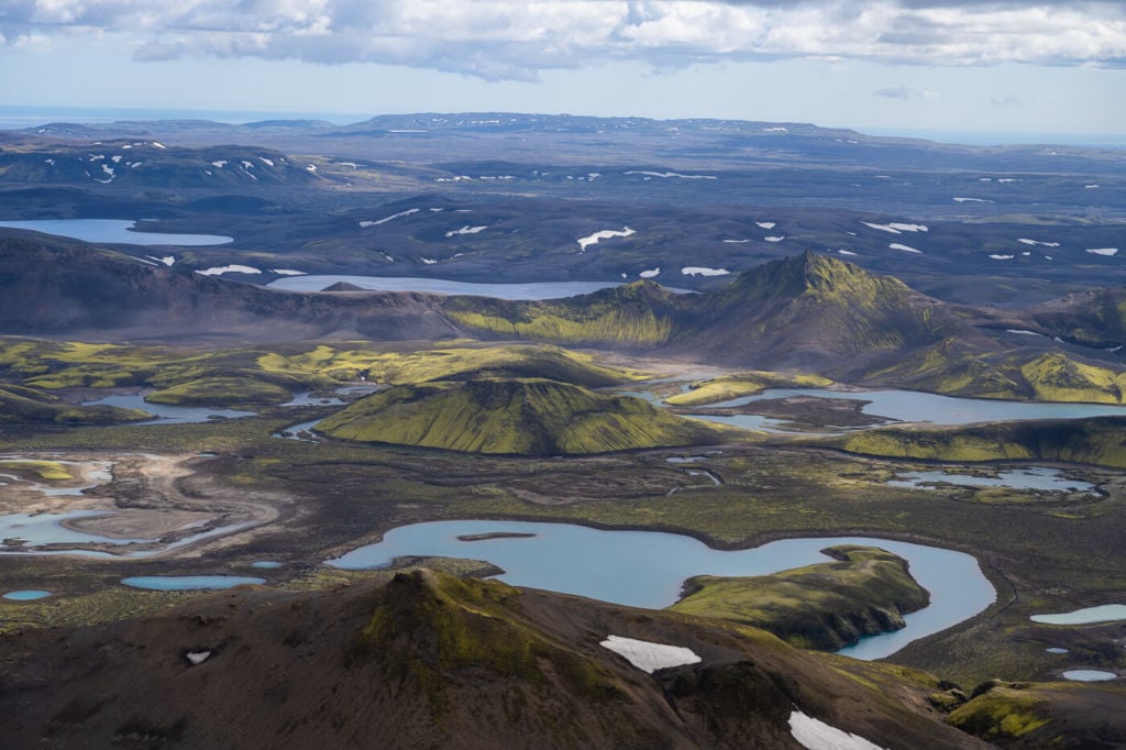
As you keep going up, you will reach a flattish area. From here, you already get a sense of the vastness of the landscape. The views will progressively open up to the south, and you will also get a good view of Langisjór to the north about halfway through the hike. That lake is over 20km long.

View to the north over the 20km long Langisjór lake.

View to the South.
Once you hike past his area, the second steep part of the trail will begin. This is also where the ground is softer and crumblier, so caution is required.
The summit is at the end of this second steep part. A cairn marks the summit. When you reach it, you’ll probably turn around on yourself instinctively. Soak in the views!

View from the Summit of Sveinstindur, north side.
Photos and Photography Tips for The Sveinstindur Hike
From there, the landscape is so vast that you will want to have as much tele lens as you have :). I did lose track of time while shooting there, looking for compositions through the EVF in the ever-changing light.
With such a vast landscape in front of you, minor changes in the clouds or the light will result in new or rearranged compositions, which kept me shooting and shooting.
I did catch myself saying, “one more shot, and then I go”, several times while I was up there. When I was not shooting, I was staring at the vastness in front of me, and I spent quite some time just looking at the landscape. I would recommend you do the same.

Uxatindard viewed from the top of Sveinstindur.


The Skafta river on the right side of the image.


Map of The Sveinstindur Hike
The trail is well-marked and easy to follow. If you need a GPS track, you can download the .GPX file from the Komoot activity:
Where to Stay
This is a remote location, so options to stay overnight are limited. Two of them are the campsite at Langisjór or the Sveinstindur hut. There also is a hut run by the Highland Centre – click here for details.
Alternatively, if you are doing this as a day hike, you can go back to road F208 and drive either to the Hólaskjól Highlands Center to the south or Landmannalaugar to the North and stay there.
Other useful resources
- For a similar experience, I’d recommend checking out the Mælifell Volcano Hike.
- Check out more Photo Hikes in Iceland here.
- Discover the best hiking books and guides on Iceland.


Excellent and very useful article. I am planing to hike there next year. Thank you very much for sharing and take care.
Thanks George, glad it helped!
Great article with very useful information. We’re planning this hike tomorrow if the wheather permits. Thanks for providing so much detailed information and many pictures. It convinced my husband to go for it omorrrow!
Thanks! Hope you’ve made it up there, the views are unforgettable :)!
Muchas gracias por este artículo tan detallado de la ruta. Me gustaría desviarme hacia Langisjór en mi ruta hacia Landmannalaugar. Crees que tendré tiempo para subir a esta cima saliendo a primerísima hora de la mañana de la zona de Skaftártunguvegur, haciendo sendero de 2-3 horas en Landmanalaugar y percnoctando cerca de Hella?
Sé que con toda esta maravilla de paisajes es una ruta muy apretada, pero mi viaje dando la vuelta a Islandia en 11 días en la 2a quincena de septiembre no me deja muchas opciones. Para hacerme una idea, crees que sería posible o me aconsejas ir a solo uno de los 2 sitios? (en ese caso, cual?). Mi intención, salvo que me digas que vale mucho la pena y es posible visitar los 2 sitios, sería llegar a Hella hacia las 6 de la tarde. Estoy acostumbrado a ir por caminos remotos de montaña en 4×4.
Thank José! Doing both is feasible, but not sure if arriving at Hella by 6 pm is. If you don’t spend too much time on top of Sveinstindur, you can do the hike in a couple of hours. So it might be possible without too many breaks along the road, but you would have to leave very early in the morning.
If I were you I would try to be at Landmannalaugar between 12-13pm at the latest, which would mean leaving from Sveinstindur probably at 10am, so starting the hike about 8am or earlier. Like that it may be feasible.
Hope this helps. By the way, this is always the problem with Iceland: too many places and too little time :)!