Upper Hvannárgil Canyon Hike – Iceland
This is a hike through the Upper Hvannárgil Canyon, which lies in the Thórsmörk Nature Reserve. The pristine beauty of this landscape is one of the best in Iceland and one where you can almost feel the forces that shaped it.
The Upper Hvannárgil Canyon Hike is a pure natural beauty. Glaciers, waterfalls and lush green mountains are all part of the package.

The Hvannárgil canyon
This is the hike I enjoyed the most during my stay in Thórsmörk. Not necessarily from a photographic point of view, but primarily due to its natural and untouched beauty.
Moreover, most of the hike on the upper ridge of the Canyon has no signs of civilisation. To me, this adds a lot to the whole experience.
I hiked the upper part of the Canyon in heavy rains, and despite this, it was one of the hikes I enjoyed the most in Iceland. That’s how much I enjoyed it :)

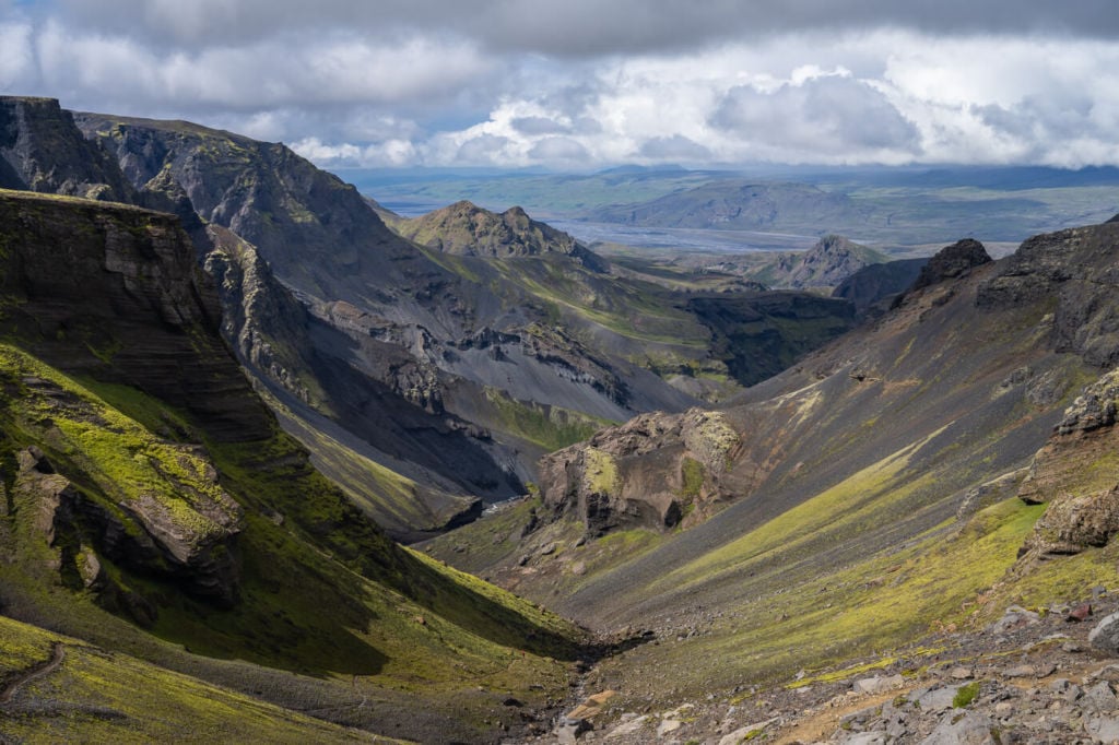
Panorama from the second part of the trail.
Outline of the Upper Hvannárgil Canyon Hike
- Getting there: unless you have your own Super Jeep and have experience crossing potentially dangerous rivers, you should take one of the buses or private tours that offer transportation to and from Thórsmörk. The closest camping site to the trailhead is Basar, followed by Langidalur. Volcano Huts is in the valley next to this one.
- Start of The Hike: From any of the starting points mentioned above (Basar, Langidalur or Volcano Huts), you will need to head toward the beginning of the Fimmvörðuháls trail. Thórsmörk side, of course :). In my case, I started the hike from the Volcano Huts and passed by each of the two other campsites. So you could still use the GPS from my Komoot activity if you wish to do so.
- Photography & Scenery value:
- Difficulty: Hard, with very exposed sections on a narrow trail that leaves no room for errors.
- Tip: more of a warning than a tip. This is a long, strenuous hike with challenging and very exposed sections. Make sure you are fit enough for this hike and avoid it if you are afraid of heights. If you do not have experience on exposed trails, I would recommend looking for a guided tour. Also, you may want to use hiking poles on this one, considering there are some section on unstable ground.
On the Trail
| Distance | Ascent | Duration |
|---|---|---|
| 21.4 Km | 730 Mt | 8/9 Hrs |
Let me start with a warning: this is a very long hike with exposed sections over the Canyon below. The trail is also very narrow in places, and there is no room for error. A misstep, and there’s no way back. And I don’t mean a way back up the Canyon.
With that off the way, let’s talk about the trail! It’s possible to divide this hike into two sections. The first part follows the north section of the Fimmvörðuháls trail. The second part of the trail is directly above the Hvannárgil Canyon. The landscape each part of the trail has to offer is quite diverse, which adds to this hike’s beauty.
First part of the Upper Hvannárgil Canyon Hike
I started this hike at the Volcano Huts, where I was staying. If you are staying at the Langidalur or Basar campings, the hike will be shorter, especially from the Basar camping. Whichever the starting point, you will have to follow the Krossa river upstream for the first part of the hike. The next turning point will be the north trailhead of the Fimmvörðuháls trail, which constitutes the first part of this hike. The trail marks are blue for this part of the hike.

Looking back down toward the Krossa river.

Blue trail markers on the Fimmvörðuháls part of the trail
From here onwards, the trail will progressively head uphill. There are no steep sections here, although you will have to hike on a couple of exposed ridges. The trail is well marked and very easy to follow at all times. Next, you will reach a plateau with great views over the surrounding glaciers.

Keep following the trail until you see the red trail marks pointing down a rather steep incline. That’s where the second part of the hike starts.
At the top of the second part of the hike, looking down.
Second part of the Upper Hvannárgil Canyon Hike
As you start heading down the steep mountainside, you will notice the hike may not be as easy as it looks. The terrain here is steep and crumbly. Carefulness is required to not slide down the mountainside. Keeping your balance here is a good core strength exercise.

First part of the steep descent, looking back up.

Panorama from the trail.
The trail will gradually flatten out as you progressively make your way down the mountain. Here the trail is very well marked and easy to follow too.
Most of the hike follows the river downstream, and you will have to cross it a couple of times. Soon you will approach the head of the Canyon, where the most exposed sections of the trail are. The path here is very narrow and crosses small water streams over exposed areas. It requires you to think carefully about where you will lay down your next step.
For the next couple of Kilometers, this is how the trail will be, with a few safer sections here and there. But on the other hand, this is also the most pristine and scenic part of the trail.
As you keep heading down the Canyon, you will reach the Basar camping again, where the hike ends.
Photographing the Upper Hvannárgil Canyon Hike
The first part of the trail (the north part of the Fimmvörðuháls trail) offers scenic views of the Krossa river and the glacier’s tongues to the east and the south.

Some of the spectacular glaciers and landscapes on this hike.
The second part of the hike is, on the other hand, arguably the best one for photography. Moreover, right from the start, the second part of this hike offers fantastic views over green mountains and waterfalls even before reaching the Canyon.

View at the start of the Hvannárgil Canyon. The gorge can be seen in the background in the middle of the photo.
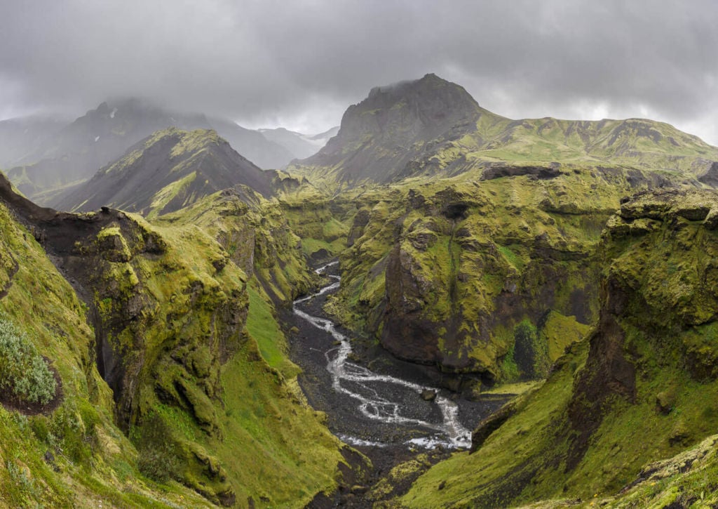
View of the Hvannárgil Canyon

Converging rivers in the Hvannárgil Canyon.

Classic view from one of the vantage points toward the end of the hike.

Possibly a Leccinum scabrum
The Canyon itself is the main highlight of this hike. Several vantage points along the trail offer great views over the gorges and rivers below. Compositionally, the possibilities are endless. This is fun shooting!
On this hike, I had my 14-24 and 24-40mm lensed, and I think they were more than enough. I did not feel the need to have any longer reach on this hike.
Map of the Upper Hvannárgil Canyon Hike
I need to stress this again – you can use the GPS file if you wish to, but bear in mind that this hike includes very exposed sections on a narrow trail over the Hvannárgil Canyon.
Where to Stay
If you plan to hike around in Thórsmörk, I recommend staying there for a couple of nights.
Hiking in Thórsmörk is time well spent; the scenic views and pristine environment are hard to find elsewhere.
There are three options if you are planning on spending one or more nights here:
- Volcano Huts: there is a hut with a restaurant, Yurts and private rooms for 2-3 persons with shared bathrooms, apart from the camping. There is a small hot pool available for use too. And warm showers for guests. Here’s their website.
- Basar: Hut and camping available, plus other amenities that can be checked on their page.
- Langidalur: Hut and camping are available here too. Here’s their page.
Additional Resources
- Other awesome hikes in Thórsmörk: The Valahnúkur hike, or the Stangarháls Hike, or Útigönguhöfði.
- Check out more Photo Hikes in Iceland here.
- Discover the best hiking books and guides on Iceland.


Hi. Thank you for your great posts. I will be in Thorsmork in 2 weeks with my family. We will spend 2 days in Thorsmork hiking. We were planning on doing 2 hikes: 1- going to Rjúpnafell (other side on the Krossa) and 2- doing a portion of the Fimmvörðuháls or alternative doing the loop you mentioned.
A- would you do this loop counter clockwise for safety? So up.the canyon and down Fimmvörðuháls. B. Is the view from the Fimmvörðuháls portion better/different than Valahnukur? Thanks
Hi Veronica, Thanks!
1- If you are planning to hike to Rjúpnafell, I would recommend this loop. The Stangarháls viewpoint has spectacular views.
2- Yes, counterclockwise would be best for safety as this will give you the chance to turn back if you need to. Long stretches of the trails are very exposed over the canyon below, and there really is no room for errors. A fall will be fatal. Also, the best part of this trail is the canyon, and I would say the views from Valahnukur are better compared to the northern part of the Fimmvörðuháls. So you could consider doing part of the Canyon hike (there also are 2-3 connecting trails which you could consider) and also Valahnukur.
Thanks so much for your help! Really appreciate it. Enjoy Iceland!
Thanks!