The Stangarháls Hike in Thórsmörk, Iceland
The Stangarháls Hike in Thórsmörk is a moderately difficult hike to one of the most stunning viewpoints in Thórsmörk, Stangarháls. The trail follows the Krossa river upstream up to the viewpoints where you will have breathtaking views of the whole Canyon below you and the glacier surrounding it; Eyjafjallajökull and Mýrdalsjökull.

Thórsmörk is the favorite place of many Icelanders, and it’s on hikes like this that you can understand why. Also called Goðaland, or the Land of the Gods, the area you will be looking at is incredibly beautiful.
Glaciers, Rivers, Canyons, and Waterfalls; there are all the ingredients for epic landscapes, and epic it is. Furthermore, the size of it all boggles the mind.
A quick note on the trail before diving into the details; I did it one way and returned the same way, including Valahnúkur at the end and the beginning. However, you can also reach Stangarháls via the Tindfjoll ring trail and include Rjupnafell on the way too.
Table of Contents
Overview of the Stangarháls Hike in Thórsmörk
| Max Altitude | 517m |
|---|---|
| Distance | 12.6KM |
| Elevation Gain | 750 / |
| Hike Time | 4:00 / 5:00 Hrs |
| Hike Difficulty | Moderate |
")
How to get to Thorsmork
Getting to Thórsmörk requires some planning as it is a hard to get to location.
- Transpostation: You can book a spot on one of the Highland buses from Reykjavik, Selfoss, Hella or Hvolsvöllur Travel Experiences or Reykjavik Excursions. That’s what I did. There is ample free parking available at each location. I left my rental at the Hvolsvöllur gas station for three nights with no issue whatsoever.
- Driving Directions: Don’t try driving there. Take any of the available buses or a private super jeep tour. There are seriously dangerous glacial rivers to cross.
The trail to Stangarháls
I started the hike at the Volcano Huts, the farthest of the three camping from Stangarháls. As mentioned earlier, I included Valahnúkur on the hike to and from Stangarháls, but you can easily skip it by taking the trail connecting The Volcano Huts to Langidalur. Still, I’d recommend including Valahnúkur on the trail, possibly in the afternoon or for sunset. Of course, this applies only if you have not already planned a separate hike to Valahnúkur :)
Anyway, back to the trail. Initially, the trail follows the Krossa upstream, next to its riverbed. Then the trail will slowly gain elevation, and the views over the Krossa river Valley and the surrounding landscape will gradually open up.

View of the Krossa river from the trail, looking toward Stangarháls.

Looking back toward Valahnúkur, the “small” mountain on the right-hand side.
The trail continues straight, crossing some birch woods here and there. There are no steep or very exposed sections along the trail – unless you intentionally approach some cliffs along the way.
As the trail keeps gaining elevation, the views will improve until you finally reach the Stangarháls lookout. Enjoy the views!
Photos and Photography tips for The Stangarháls Hike in Thórsmörk
This is one of those hikes where I’d recommend bringing all the gear you have. At least anything between 14mm to 200. Even above that if you can. Why? Like in any other location in the highlands of Iceland, the views are so vast and the landscape so immense that you will want to have that extra reach to isolate various parts of the landscape from the rest. Even more so considering all the glaciers, valleys and rivers around.
Each focal length will find its use here, but I had the most fun with the 70-200mm for the reasons I mentioned above. You can see what I mean by that in the photos here below, as several photos are within that focal range.
Lastly, if you plan this hike, I’d highly recommend including Valahnúkur on the way back for sunset. If the light is good, it will be a light show.

One of the many 200mm shots I took.

Light and rain on the glaciers.

Cliffs in the fog. Lighting conditions are often dramatic in Thorsmork when it is not raining.

Rain on some faraway mountain.
One of the many great views on the trail.

Unnamed waterfall – as far as I know, at least :)
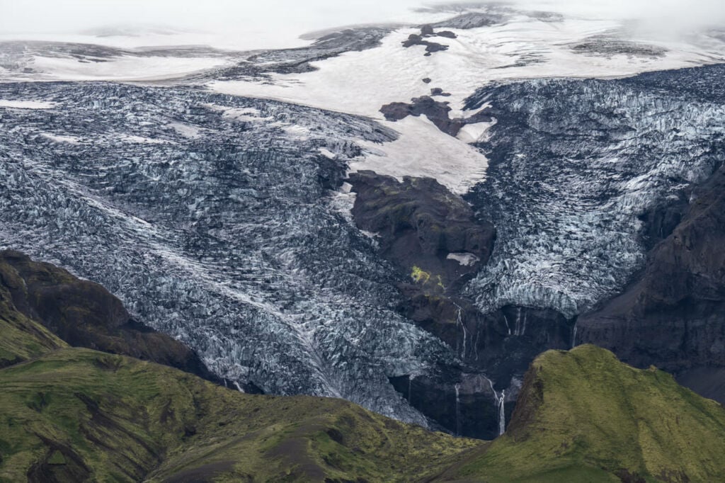
One of the many glaciers you will see along the trail
Light on a mountain.
View of the Korssa River.

The lush green landscape of Godaland

Rainbow over Thórsmörk

Drone shot of the Stangarháls viewpoint.
Map of The Stangarháls Hike in Thórsmörk
The trail is well-marked and easy to follow. If you want to download the GPS file, you can do so from the Komoot activity linked below.
Where to Stay
If you plan to hike around in Thórsmörk, I recommend staying there for a couple of nights.
Hiking in Thórsmörk is time well spent; the scenic views and pristine environment are hard to find elsewhere.
There are three options if you are planning on spending one or more nights here:
- Volcano Huts: there is a hut with a restaurant, Yurts and private rooms for 2-3 persons with shared bathrooms, apart from the camping. There is a small hot pool available for use too. And warm showers for guests. Here’s their website.
- Basar: Hut and camping available, plus other amenities that can be checked on their page.
- Langidalur: Hut and camping are available here too. Here’s their page.
If you don’t want to or can’t spend the night here, you should search for the company that allows the most time between to and from trips. I would recommend checking out their schedules here:
Additional Resources
- Other awesome hikes in Thórsmörk: The Valahnúkur hike, the Upper Hvannárgil Canyon Hike. or Útigönguhöfði.
- Check out more Photo Hikes in Iceland here.
- Discover the best hiking books and guides on Iceland.


Leave A Comment