Valagil Waterfalls Hike, Westfjords, Iceland
The Valagil Waterfalls Hike is easy to miss if you don’t know they it’s there. Located deep in the Westfjords region of Iceland, this hidden gem is home to some beautiful waterfalls cascading into a ravine made of multiple lava layers.

Valagil
This is the perfect spot for a short and easy hike if you are on a road trip in the area. The hike to Valagil will take about 40 minutes in total and it’s well worth the time it takes to visit it.
I have found conflicting information about its height but in total, it probably is just about 100 meters. So definitely a mighty sight.
Other than that, this location offers some additional bonus and unnamed waterfalls for those who are ready to walk further.
At an additional 30-minute walk, lies another spectacular ravine with some amazing waterfalls. I could not find names for these other waterfalls, so they’re a bit of a mystery, but here is one.

Another apparently unnamed ravine and waterfalls close to Valagil.
If you have a little extra time, it’s worth walking up to them. More details below.
Going to Iceland? Blue Car Rental Discount!
As a reader of The Photo Hikes, you get a 5% discount on your car rental when booking with Blue Car Rental through this website. The discount will be automatically applied to the booking through the following link
Table of Contents
Overview of the Valagil Waterfalls Hike & Map
The data in the table below refers to the whole hike up to the second ravine past Valagil.
| Max Altitude | 210 m |
|---|---|
| Distance | 7.80 KM (4km Valagil) |
| Elevation gain | 300 m ↑ / 300 m ↓ |
| Hike time | 01:30/ 02:00 Hours (One hour Valagil only) |
| Hike Difficulty | Easy/Moderate |
Here is also the map of this hike. you can download the GPS track for free from the activity linked below
How to get to Valagil and Parking
Located in the fjord called Álftafjörður near the village of Súðavík, there’s only one possible way to get to Valagil, via Road 61 or Djúpvegur. A very scenic road too BTW. From the West, the drive from Ísafjörður will take just about 30 minutes.
- Driving Directions: if you are coming from Ísafjörður it’s easy to get to Valagil; you can just follow Road 61 up to the parking area. From the opposite side, it’s a very long drive from any large inhabited area, so it makes sense to stop here if you are also headed to Ísafjörður from the East.
- Parking: a free, very large parking area is available at the trailhead. It’s got some benches for a picnic too.
- Public Transport: none available. Apparently, there used to be a bust-stop Súðavík, but as it seems, it may no longer be there.

The very large parking area by the Valagil trailhead. Also a great place to rest and have a picnic.
The Valagil Trail
The trail starting from the Parking area up to Valagil is well-marked and easy to follow. Mostly flat, the trail is marked with blue trail marks and it’s about 2 km from the parking area.
You cannot see Valagil from here as it is hidden inside the ravine. As you walk down the trail, however, you will start hearing the unmistakable and soothing sound of water falling. Shortly after, you will see the ravine and the waterfall up to your right.

Valagil trailhead.

the trail continues on flat guns before turning right to valagil.
You can walk up and down along the rivers for a bit, but I saw no safe way to get much further up the hill. Even if you could, there would be no better view of the waterfall as it is deep into the ravine.
What you can do is cross the pedestrian bridge downstream and from there you can walk closer to the riverbed. Either from the bridge or on the other side is where you can get the best views.

View from the Bridge

One of the smaller waterfalls on the other side of the ravine.
At this point, you can either turn back or if you have enough time and your curiosity gets you, you can keep following the trail toward some more waterfalls further down.
The hike to the other gorge will take about one additional hour from Valagil and back to it. If you have the time, it’s more than worth it. However, the trail is a little more difficult. There are a lot of soft-ground, uphill sections where it is easy to slip.
On the other Han,d you’ll be able to see 3 to 4 additional, beautiful waterfalls on this trail. It honestly was a very pleasant surprise.

Middle part of the second ravine.

Looking back toward Valagil (on the left side) from the trail to the second ravine.
The Valagil Waterfalls Hike Photos and Photography Tips
The tallest waterfall in the Valagil is quite deep into the ravine and it’s not possible to get very close to it. This makes it a bit hard to photograph.
The best option is to get close to one of the smaller waterfalls downstream, close to the pedestrian bridge that crosses the river. compositions are somewhat limited and will depend on water levels, but that’s where you can get the best foreground.

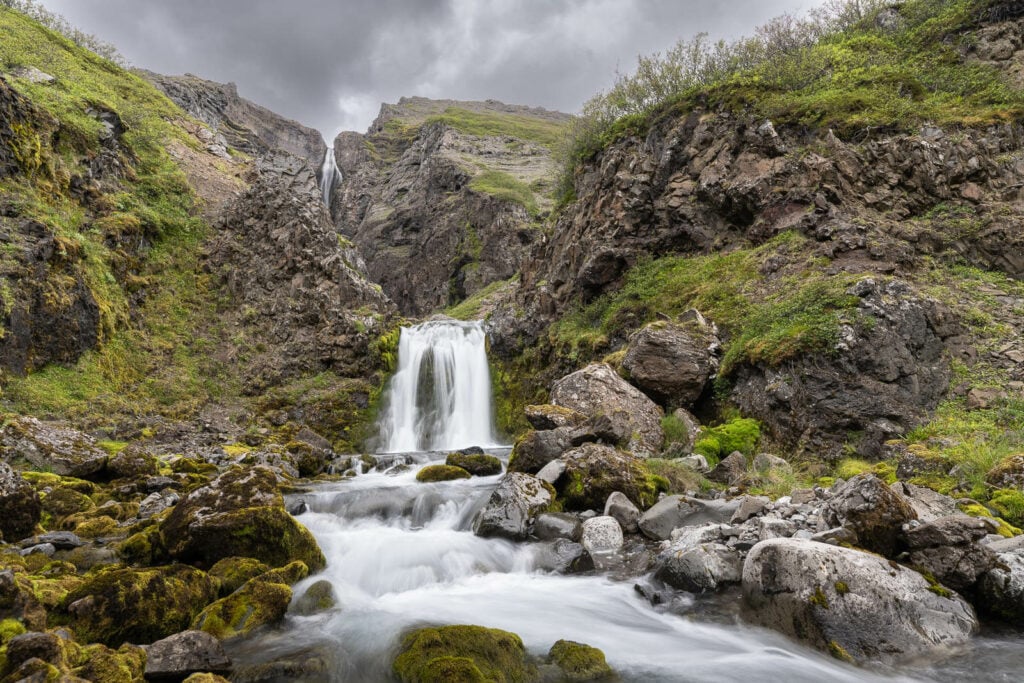
I think the other unnamed ravine further down the trail is much better in terms of landscape photography. This is my own opinion, of course, but I’ve found its waterfall to be more “scenic” if you will.
You still cannot get very close to each one of those waterfalls, but you have better views compared to Valagil.

One of the many waterfalls of the second ravine

This second ravine also offers rather interesting geological formations


I took all these photos with my 24-70m lens (full frame) and I doubt anything wider may be very useful. Since you cannot get v very close to each one of the waterfalls at this location, they would look way too small to be of any interest.
Where to stay
Isafjordur will be where you can find the most choice in terms of accommodation and dining options. It’s the largest town in the area. However, you’ll also find several guesthouses, private accommodations, or campsites all along Road 61.
Additional Resources
- Don’t miss the Dynjandi Waterfalls Hike if you are in the Westfjords.
- Check out more Hikes in Iceland here.
Leave A Comment