The Brennisteinsalda Hike in Landmannalaugar – Iceland
The Brennisteinsalda Hike in Landmannalaugar is almost a magic journey through an active volcanic landscape. In fact, Brennisteinsalda is an actual Volcano. And a very colourful one.
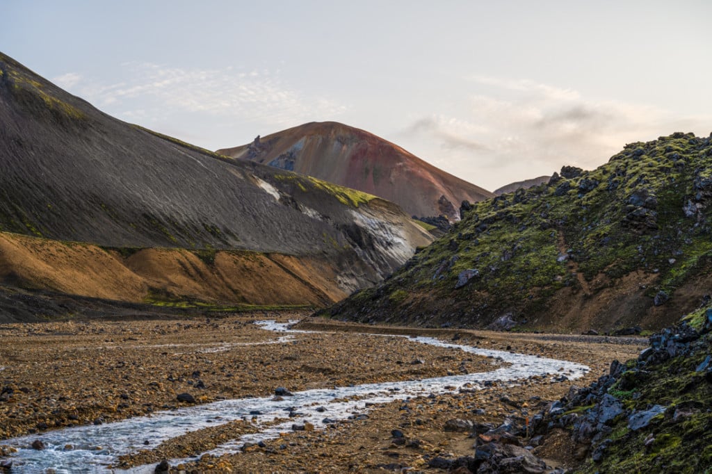
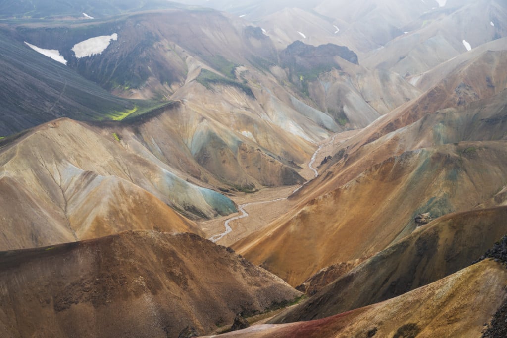
The top of Brennisteinsalda, in the background, viewed from the Graenagil Canyon.
That’s also reflected in its name; this beautiful mountain (855 m) takes its name from the sulfur spots that color it. The Brennisteinsalda name means “Sulphur waves”, due to the various colorful spots of sulphur along its slopes.
While most of the photos you see only are way over-saturated, it still is a very colorful mountain. It is almost like stepping into a surreal painting where Mother Nature went all out with her vibrant colors.
Along with hikes to Sudurnamur and Blahnúkúr, Brennisteinsalda is one of the best hikes in the area, and probably the easiest out of the three if you are hiking it directly from the campground. A very popular choice for a day hike is to combine Brennisteinsalda with Blahnúkúr – so if you’re up to it the loop is highly recommended.
No shortage of unique views from the top of Brennisteinsalda.
How to get to Brennisteinsalda and Overview of the Hike
- Getting there: This Hike is only possible in Summer as the F roads leading to Landmannalaugar are only open from June/late June until mid/late September. If you are driving, a 4WD is required. It is advisable to take the F208 North to Landmannalaugar as there is no river crossing until you get to the camping ground, and it’s suitable for smaller 4WD cars, like a Dacia Duster or a Suzuki Jimny. You can leave the car in the parking lot by the river. A small pedestrian bridge will allow you to cross the river from there. You should only attempt to get to Landmannalaugar via other F Roads (like the F208 south) with larger 4WD as the river crossings are unsuitable for a small 4WD car.
- Please note: as of June 20th, 2024, you will need to reserve parking in advance if you plan to visit Landmannalaugar between 9 AM and 4 PM (source). You can reserve your parking spot in Landmannalaugar here. The reservation system will be in place every year between June 20th and September 15th.
- Start of The Hike: the Landmannalaugar campground
- Photography & Scenery value: some of the best views of the famous and colorful Rhyolite mountains of Landmannalaugar. Bring a Telephoto lens to make the most out for those views.
- Difficulty: Moderate
- Tip: Instead of making a single trip and back, you could include the Blahnúkúr hike on your way back. Or on your way to Brennisrtenisalda :)
To rent a car, I can recommend Blue Car Rental; you also have a 5% discount when booking through The Photo Hikes. If you prefer a CamperVan, I can also recommend CampEasy. Make sure your vehicle is allowed on F-roads before booking, though.

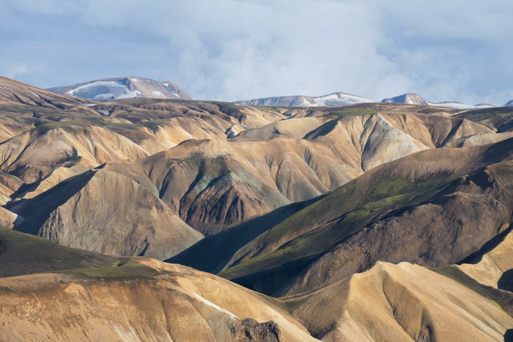
The stunning, endless landscape around Landmannalaugar. The top of Brennisteinsalda is a great place to admire it.
The Brennisteinsalda Hiking Trail & Map
| Distance | Elevation Gain | Hike Time |
|---|---|---|
| 8.04 Km | 300 Mt | 2.30/3 hrs |
Here is the map of the hike from the parking area. If you need a GPS track, you can download the GPX file from the Komoot activity.
Like all the trails in Landmannalaugar, Brennisteinsalda’s is also nicely sign-posted and easy to follow.
However, there are several options available to hike the top of Brennisteinsalda. You can hike Brennisteinsalda directly from the campground through the Graenagil Canyon, through the Laugahraun lava field, or in a loop from/to Blahnúkúr.
The easiest option would be through the Graenagil Canyon, which is the one I have taken and also the trail I am describing here.
The hike is mostly flat, with the only steep climb toward the top of the volcano. Once you reach the top, you can either go back the same way or do a loop via the other routes. I’d particularly recommend including the trail through the Laugahraun lava field if you prefer to do a loop instead of an out-and-back hike.
In my case, the trail started at the head of the Graenagil Canyon, from where you can already see the top of Brennisteinsalda. You can easily get there by following the Graenagil/Blahnukur signs from the Campsite.
The top of Brennisteinsalda viewed from the Graenagil Canyon
From the Graenagil Canyon, you can follow the trail upstream, until it turns into the Laval field on the right, where it slowly starts climbing. Honestly, this part of the lava field is my least favorite part of the hike. Lots of big lava rocks you have to step on/off and the trailmarks are sometimes difficult to follow.
Anyway, you will soon be out of the lava field. You will also start seeing the active volcano’s fumaroles above you and further up on the trail.

Brennisteinsalda, viewed from the trail through the lava field.

Fumaroles on Brennisteinsalda

Very active fumaroles
Once you reach the gated fumaroles area, the trail continues on the back of the mountain, where it will turn right for the last steepish climb to the top. Here the views will start to open up, slowly revealing the beautiful shapes and colors of the surrounding mountains.
The top is rather wide and flat and, of course, the best spot to admire the surrounding Rhyolite mountains. As mentioned earlier I’d recommend doing this as a loop – at least through Laugahraun, for more beautiful and diverse views.

View from the trail above the fumarole area

View from the trail before the start of the uphill climb section to the top.

The top of Brennisteinsalda, viewed from the direction opposite the campground.

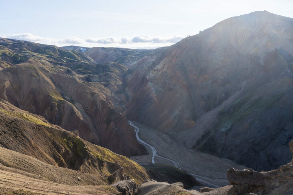
Descending on the opposite side toward the Laugahraun lava field provides more amazing views.
Photos and Photography Tips for the Brennisteinsalda Hike in Landmannalaugar
If you want to take photos of the Brennisteinsalda mountain, this is best done from the surrounding areas. The Blahnúkúr hike probably offers the best views of the colorful Brennisteinsalda volcano.
However, from the top of Brennisteinsalda, you will have some of the best views of the Rhyolite mountains to the north. For this reason, I think the best lens to have on this hike is a telephoto lens in the 70-200m range.
Generally speaking, this is probably the most fun lens you can use in Landmannalaugar, as it allows you to focus on the farther mountains and the endless landscapes around them There are plenty of interesting shapes and colors in the surrounding mountains to point your camera at from the top.
If you enjoy doing landscape with telephoto lenses as much as I do, you can easily spend one hour or more up there just taking photos or looking through the viewfinder. Time will fly up there.
Also, I did not find much use for ultra-wide lenses. If you have to choose to keep the backpack weight low, something in the 24-200mm range should be more than enough.

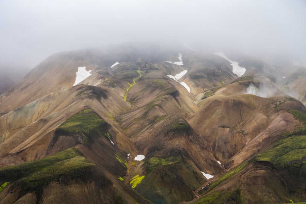
The very unique colors of the rhyolite mountains around Brenisteinsalda.

View from the trail close to the lava field

Another view of the Rhyolite mountains to the north from the trail

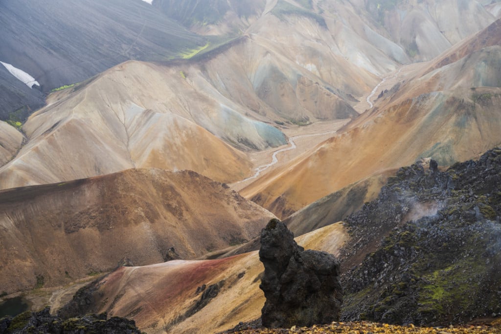
Blahnúkúr viewed from Brennisteinsalda
Details of the Colorful Rhyolite mountains

Lastly, flying a drone here isn’t possible. From the top of Brennisteinsalda is not allowed. Landmannalaugar is part of the Fjallabak nature reserve, where flying drones is prohibited. Unless you have obtained a special permit to do so; you can apply for that
Where to Stay
The Camping Ground is the most obvious choice if you have a tent. The price seems to change every year but you can expect to pay around 30 USD/EUR. Also, there is a hut where up to 78 guests can be accommodated in dorm rooms, which needs to be booked well in advance. If you have a camper van, it’s ok to sleep in the parking lot, but you would have to pay to use the hut’s facilities.
For more details, check out my guide to Hiking and Camping in Landmannalaugar, linked below.
Additional Resources
- Check out my comprehensive “Guide to hiking and camping in Landmannalaugar“
- Check out more Photo Hikes in Iceland here.
- Link to the website of the Icelandic Touring Association managing the hut
- Discover the best hiking books and guides on Iceland.
- Check out the Best 5 Day Hikes in Landmannalaugar with Maps
If you have a question or want to share your own experience here, let me know in the comments.


Hey Marco!
Me and my wife are going to pay a visit at Landmannalaugar this September. Your website is super handy, thank you for the information! If you don’t mind we would like to ask your advice on something. So after reading your desctiption we will do the Brennisteinsalda hike for sure! After seeing the photo’s of the first part of the Blahnúkúr hike we are very curious about that one too. I do have a prosthetic leg but hiking isn’t a problem at all. On the other hand I don’t want to be too reckless. Until which part of the Blahnúkúr hike would you advise us to go? We don’t want to do the full hike but just want some extra amazing views after the Brennisteinsalda hike. The Blahnúkúr hike seems to offer this!
Kind regards,
Robin & Eleni van Damme
Hi Guys,
I’d recommend going up from the side opposite Brennistensalda, in the same direction I describe on my Blahnukur post. Essentially doing the BLahnukur hike clockwise.
It’s the shortest way to get to top, and offers different views compared to the side next to Brennistensalda.
Hope it helps – Enjoy your visit!
.