Hike to Holandsmelen – Lofoten, Norway
The hike to Holandsmelen on the Lofoten island of Vestvågoya is dear to me. One of the very first hikes I went on in the Lofoten back in 2015. The hike is easy, never steep, and there are no exposed sections. The top’s panoramic view is stunning; additionally, the summit offers an incredible 360- degrees view of the Vestvågoy Island.
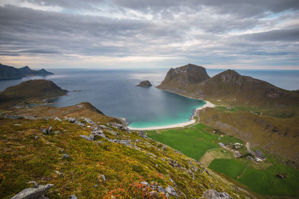
View from the top toward Vik and Haukland beach. The two mountains on the right-hand side are Mannen and Veggen.
While the mountains here are not as dramatic as the ones to the south, the views are still very scenic and, in a way, a more relaxing sight. The white sand beaches of Haukland and Vik and their crystal blue waters easily remind of locations closer to the tropics, and on a sunny day, one can sit on the top of the mountain, enjoy the mild warmth of the arctic sun and the fantastic views from the top.
Outline of the Hike to Holandsmelen
- How to get to Holandsmelen & Parking: there are three different trailheads to get to the top of Holandsmelen. In this post, I will describe the most popular route, the one stemming from the road to Uttakleiv. You would have to turn on the road to Uttakleiv from the E10 highway to get there from either Leknes or Reine. Keep following it until you reach the parking area. You can leave the car on the small pull-out area by the side of the road at these coordinates or drive a little further up the gravel road to a clearing, which seems to be a fairly popular van camping location.
- Start of The Hike: while the top of Holandsmelen is not immediately visible from the parking area, you will see a couple of trails heading uphill into the bushes. That is the start of the hike.
- Photography & Scenery value: great panoramic views and 360 degrees views of the Vestvågoy island, as well as scenic views of some of the best white sand beaches of the Lofoten Islands.
- Hike Difficulty: easy to medium
- Tip: for the seasoned hikers looking to combine multiple hikes into one day, you can combine this hike with other shorter ones in the area, such as Veggen, Mannen or Offersøykammen. Apart from that, anyone should pay a visit or spend the night camping at either Haukland beach or Uttakleiv. During Northern lights season, you are guaranteed a prime scenic spot at any of these locations.
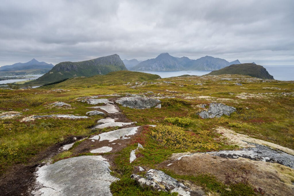
View from the trail, halfway through the hike. The mountain on the left is Offersøykammen, and the one close to the centre is Stornappstinden. Both hikable mountains with great views.
On the Trail
| Distance | Ascent | Hike Time |
|---|---|---|
| 5.78 Km. | 450 m | 2:00 / 2:30 Hrs |
Like most on the Lofoten islands, the trail isn’t marked, but it is easy to follow nonetheless. However, while it is a well-worn trail, several other trails are converging into or stemming from the main one, so you want to keep following the one heading toward the general direction of the mountain. Or, you can download the GPX track from the Komoot activity linked below.
Anyway, back to the hike. You can follow the white-gravel road uphill from the small pull-out parking area. The trail will then enter a small birch forest. Here it can be pretty slippery and muddy if it has rained recently. After about 10-15 minutes, you will reach a clearing and a mostly flat area, and the summit will be in full view.

The parking by the side of the road, toward Vik and Haukland.

The gravel road which connects the parking area to the trail.
This is the easiest part of the trail, as it is primarily flat. However, there could be a few boggy sections in the lower points where the rain collects. Once you cross this flattish area, the trail will gradually start to gain elevation again. It gets steeper and rockier as you approach the summit. However, it is never too steep here, but the terrain is very rocky, and you’d have to watch your step.

Finally, you’ll find a cairn at the top of the mountain and the fantastic views around you!

The last bit of the trail and the Cairn at the top.
Best view from the top!
Photos of the Hike to Holandsmelen
This hike offers great views from the summit and several scenic spots along the way. Once you exit the small birch forest, the last few birch trees make for a good foreground. The views from the top are, of course, the main highlight of this hike.

One of the many birch trees along the first part of the trail.

The trail with the summit of Holandsmelen in the background.

Another birch tree with Holandsmelen in the background.

One of the mostly flat parts of the trail.

View from the summit of Holandsmelen toward the North.
Same view on another hike earlier in the season.

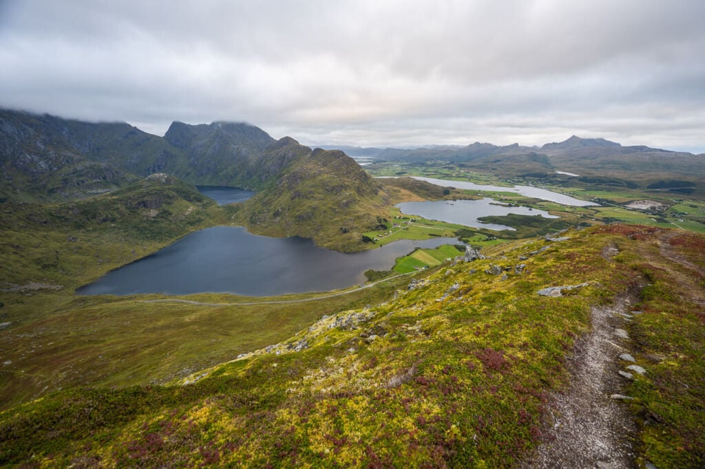
View from the top toward Stornappstinden (South).

Finally, the fantastic view from the top toward the Vik and Haukland beaches.
To summarise, this hike is one of the best short hikes in the area. It’s not too physically demanding, so if you are on the first day in the Lofoten and have just arrived from a long trip, you could consider this one for the day.
Map of the Hike to Holandsmelen
Here is the map of the Hike to Holandsmelen. If you need a GPS track, you can download the .GPX file from the Komoot activity.
Where to stay
There are a few spots suitable for camping around the top of the mountain, otherwise:
- The Lofoten Beach Camp is the closes option. The Haukland and Uttakleiv campings are also quite close.
- Several Rorbu and cabin accommodations are also available nearby.
Additional Resources
- If you are in the area, you may also want to check out these great hikes: Veggen, Mannen and Offersøykammen.
- Check out the main page on Hiking in Norway for more Photo Hikes and inspiration.


Leave A Comment