The Flakstadtind Hike – Lofoten Islands, Norway
The Flakstadtind Hike offers excellent views over the beaches of the Flakstadøya island and the mountains surrounding it. The Hike is also quite short and relatively easy, so it’s a perfect option for a half a day hike.

Hustinden, in the middle
This is also a pretty popular hike. You’ll find a tiny shelter and grill halfway up, right before the steepest part of the trail, and it’s possible to use it.
This is one of the hikes where the trail is easy to follow. This is not a given in the Lofoten, where sometimes trails mysteriously disappear to suddenly reappear elsewhere. Norwegian trolls’ doing, I guess :D!
I personally enjoyed this hike. It’s not particularly challenging for the more experienced hikers, but it’s fun enough, and the panoramic views are indeed worth it. I ventured on this hike three times, but I had to turn back twice due to stormy weather. I also got rain and strong winds on my third attempt, but at least I made it to the summit.

Panoramic Image, rain coming from the West!
Also, there’s a very un-photogenic info board on the top of the mountain, but it is easily avoidable when composing your photos and does not ruin the landscape.
How to get to Flakstadtind and Overview of the Hike
- Getting there: the hike is along the E10 road. You will have to drive to Flakstad from either north or south. If you’re lucky, you may find a parking spot right next to the trailhead at these coordinates: 68.10273022542519, 13.304013028956206. There is enough space for 2-3 cars only, though. If the spots are taken, you can leave the car in the resting area next to Skagsanden beach.
- Start of The Hike: The trailhead is marked by a gate on the side of the E10 road, next to the small pullout area.
- Photography & Scenery value: From the top, you get an almost 360 degrees panoramic view, only blocked by the mountains to the south. Great views over the Flakstadpollen Fjord and a good change of perspective toward Hustinden, one of the most photographed mountains in the Lofoten.
- Difficulty: easy to medium. The second part of the hike is steeper than the first, and there are a lot of big boulders.
- Tip: considering this is a relatively short and easy hike, you could combine it with another one in the area.
The Flakstadtind Trail
| Distance | Ascent | Duration |
|---|---|---|
| 3.14 KM | 470 m. | 2.00/2.30 Hrs |
As you pass the gate marking the trailhead, you will slowly start to gain elevation. The trail is visible at all times, but it will split into different tracks in places, to reunite shortly after.
Keep following it until you reach a relatively broad flat area with a small open hut and a grill. Once you pass the hut, the steepest part of the trail will begin. If it recently rained, it can also be very muddy and slippery.


Photos taken at the beginning of the second, steeper part of the trail.
The trail is visible and easy to follow in this second part of the hike too. Even if you lose track of it, you can keep going up. The last part of the hike close to the summit has bugger boulders, and the trail disappears, but the summit will already be in sight. Enjoy the views!

View from the top of Flakstadtind
As far as I know, this is a one-way hike, so you will need to go back the same way.
Photos and Photography tips for the Flakstadtind Hike
Great panoramic views from the top, especially of the Flakstadpollen fjord, the Skagsanden beach and Hustinden. It’s a good change of perspective, especially for Hustinden and the Skagsanden beach, which are two of the most photographed subjects of the Lofoten Islands.

Panorama made with two rows of three frames each.
You also get a good view of almost the whole Flakstadpollen fjord from the top. Great views of the mountains to the north too.

Skagsanden, the beach at the bottom left, and Hustinden, the mountain in the middle. Stornappstinden is the other mountain right behind it.

The unmistakable colors of the Flakstadpollen Fjord at high tide. The first mountain on the right is Kollfjellet.
As you can see from the photo below, the north face is quite steep and you are pretty steep so that you can get a good view directly below the mountain.

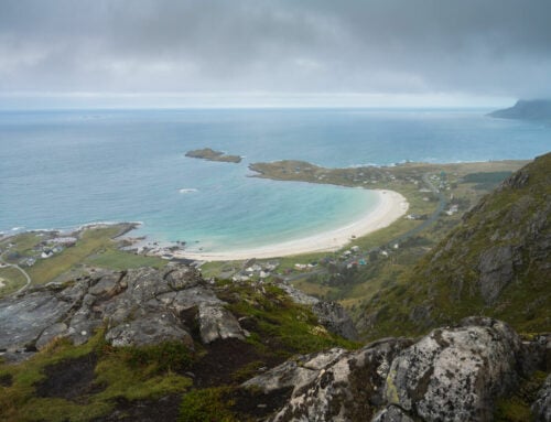
View over Skagsanden beach from the top of Flakstadtind. You can actually see the small pullout area at the trailhead right below the mountain.
I believe this would be a great location to shoot the Northern Lights from. Still, that would require Hiking up or down the mountain’s steep side with a headlamp, so I’d recommend that only to those who already have experience hiking at night on similar terrain. Otherwise, the lights would be best enjoyed by the Skagsanden beach.
Map of The Flakstadtind Hike
Here is the map of the hike. If you need a GPS track, you can download the .GPX file from the Komoot activity.
Where to Stay
There are several different options you can choose from if you are planning to spend the night in the area:
- The Lofoten Beach camp in Skagsanden is the closest one.
- Ramberg also offers several accommodations and additional facilities like coffee shops, supermarkets, and dining options.
The summit is very rocky, “big boulders” rocky. Camping there isn’t really an option. Camping somewhere lower on the mountain is feasible. A good sport would be by the shelter as the area is flat and water is available.
Additional Resources
- Check out the main page on Hiking in Norway for more hikes in Norway.
- if you are in the area, I’d also recommend checking out Ryten
Leave A Comment